
You are using an out of date browser. It may not display this or other websites correctly.
You should upgrade or use an alternative browser.
You should upgrade or use an alternative browser.
WEATHER Severe Weather the Week of April 22md, 2024 - MODERATE RISK! Saturday 4/27/24
- Thread starter packyderms_wife
- Start date
- Status
- Not open for further replies.

packyderms_wife
Neither here nor there.
Current Map | U.S. Drought Monitor.
US Drought Report, it's an interactive map.

 www.fireweatheravalanche.org
Wildfire map... never thought I'd be posting this one weekly.
www.fireweatheravalanche.org
Wildfire map... never thought I'd be posting this one weekly. 

 www.star.nesdis.noaa.gov
GOES Sat imagery... you can select different filter views, for dust, smoke, ash, etc
www.star.nesdis.noaa.gov
GOES Sat imagery... you can select different filter views, for dust, smoke, ash, etc
US Drought Report, it's an interactive map.
FWAC Wildfire Map - Current Wildfires, Forest Fires, and Lightning Strikes near you | Fire, Weather & Avalanche Center
Interactive real-time wildfire map for the United States, including California, Oregon, Washington, Idaho, Arizona, and others. See current wildfires and wildfire perimeters near you using the Fire, Weather & Avalanche Center Wildfire Map.
GOES Imagery Viewer - NOAA / NESDIS / STAR
Near real-time publication of GOES-East and GOES-West images from NOAA/NESDIS/STAR
packyderms_wife
Neither here nor there.
Crazy weather we are now expecting cold snap to move in and may see freezing temperatures tonight, so I'm watching so I can light the wood stove at the right time.
We just had a cold snap here, today it's finally warming up, might make it to 60F. I'm ready to get my indigo seeds planted.
Crazy weather we are now expecting cold snap to move in and may see freezing temperatures tonight, so I'm watching so I can light the wood stove at the right time.
For the weather watchers out there, we had a freeze last night (32F) but no frost to go with it.
Expecting a repeat of the same low temperatures tonight.
ginnie6
Veteran Member
It was crazy here over the weekend. Massive hail that caused a lot of damage they're saying. People were posting pics of it on social media. As usual we were thankfully in the Red Sea. Storms part and go around us. Friend's son lost power at work and his Harley got nailed she said. Hoping it's not too bad as he's got a once in a lifetime trip to Sturgis coming up in August.
Supposed to be cool today but warm back up to the 70's tomorrow. I've got plants get out in the garden this week and a pool to finish cleaning.
Supposed to be cool today but warm back up to the 70's tomorrow. I've got plants get out in the garden this week and a pool to finish cleaning.
packyderms_wife
Neither here nor there.
RT 9:19 - Ryan Hall y'all xtra
In this video we are talking about another severe weather outbreak on the way…

packyderms_wife
Neither here nor there.
RT 11:20 - Max Velocity
In this weather forecast, we are breaking down TWO BIG storms that will bring a multi-day severe weather event to the United States! This will bring more severe weather like damaging winds, large hail, and tornadoes. Find the latest details of the weather across the United States in our latest weather forecast.
We're expecting temps in the low 20s tomorrow night! No good for the blooming cherries and almonds...
Summerthyme
Summerthyme
packyderms_wife
Neither here nor there.
RT 9:27 - Max velocity
In this weather forecast, we are breaking down TWO BIG storms that will bring a multi-day severe weather event to the United States! This will bring more severe weather like damaging winds, large hail, and tornadoes. A tornado outbreak is possible Saturday. Find the latest details of the weather across the United States in our latest weather forecast.
It was 24 here last night. Everyone has a bug, and I'm sure it didn't help DS...he was up most of the night keeping up a fire between the two almond and cherry trees which are in full bloom. The problem is, tonight is supposed to be just as cold, and no one is in any shape to pull another all-nighter!
Summerthyme
Summerthyme
I have left a tractor with a vertical exhaust idling all night under a transparent apple tree to keep the frost away.tonight is supposed to be just as cold, and no one is in any shape to pull another all-nighter!
packyderms_wife
Neither here nor there.
RT 9:27 - Ryan Hall y'all xtra
In this video we talk about an upcoming multi day severe weather and tornado outbreak.
It's feeling kinda stormish here.
High humidity, low overcast, south wind, warm and muggy.
Red boxes up in NW Kansas.

High humidity, low overcast, south wind, warm and muggy.
Red boxes up in NW Kansas.
Friday.

Saturday

Saturday
Walbash
Contributing Member
LIVE - Severe Weather Coverage With Storm Chasers On The Ground - Live Weather Channel...
Ryan Hall is live again. Thinks Fri and Sat may be more active for the plains.
11 chasers up at Zoomradar.

 zoomradar.com
Another 10 here.
 livestormchasing.com
They think something's going to pop soon, I guess.
ZoomRadar – Interactive Weather For Your Website
ZoomRadar is one of the fastest updating interactive radars on the web, aggregating local Level 2 Doppler radars from all across the US
Another 10 here.
Live Storm Chasing
Watch live feeds as storm chasers try to see if their target verifies. Tornadoes, hurricanes, blizzards, and floods - we've got it all and more, live on our site and available as video on demand.
They think something's going to pop soon, I guess.
packyderms_wife
Neither here nor there.
Tornado Warning
KSC023-153-252230-
/O.COR.KGLD.TO.W.0003.240425T2145Z-240425T2230Z/
BULLETIN - EAS ACTIVATION REQUESTED
Tornado Warning
National Weather Service Goodland KS
449 PM CDT Thu Apr 25 2024
The National Weather Service in Goodland has issued a
* Tornado Warning for...
Eastern Cheyenne County in northwestern Kansas...
West central Rawlins County in northwestern Kansas...
* Until 530 PM CDT.
* At 449 PM CDT, a confirmed tornado was located 9 miles southwest of
Bird City, or 14 miles southeast of St. Francis, moving northeast
at 25 mph.
HAZARD...Damaging tornado and golf ball size hail.
SOURCE...Weather spotters confirmed tornado near County Road 23 in
southern Cheyenne County.
IMPACT...Flying debris will be dangerous to those caught without
shelter. Mobile homes will be damaged or destroyed.
Damage to roofs, windows, and vehicles will occur. Tree
damage is likely.
* The tornado will be near...
Bird City around 500 PM CDT.
PRECAUTIONARY/PREPAREDNESS ACTIONS...
To repeat, a tornado is on the ground. TAKE COVER NOW! Move to a
basement or an interior room on the lowest floor of a sturdy
building. Avoid windows. If you are outdoors, in a mobile home, or in
a vehicle, move to the closest substantial shelter and protect
yourself from flying debris.
&&
LAT...LON 3985 10128 3957 10155 3957 10161 3958 10168
3994 10159
TIME...MOT...LOC 2149Z 214DEG 20KT 3962 10162
TORNADO...OBSERVED
MAX HAIL SIZE...1.75 IN
$$
Trigg
packyderms_wife
Neither here nor there.
BREAKING TORNADO ON THE GROUND IN KANSAS - Strong Tornadoes Possible - With Live Storm Chaser
LIVE STREAM - Max Velocity
packyderms_wife
Neither here nor there.
packyderms_wife
Neither here nor there.
packyderms_wife
Neither here nor there.
One that we’re all looking forward to!I'm late to the party. When I last looked at tomorrow's storm in Iowa, it just supposed to be a "rain event."
FB reports of wind damage in Shawnee, maybe tornado.
They've had direct hits 2-3 times in the last few years.
Red boxes marching east, #16.
This system ain't done yet.
They've had direct hits 2-3 times in the last few years.
Red boxes marching east, #16.
This system ain't done yet.
packyderms_wife
Neither here nor there.
LIVE STREAM - Max Velocity
BREAKING Tornado Warning In Texas - Strong Tornadoes Possible - With Live Storm Chaser
packyderms_wife
Neither here nor there.
Nebraska
Severe Weather Statement
National Weather Service Hastings NE
1214 PM CDT Fri Apr 26 2024
NEC019-163-261745-
/O.CON.KGID.TO.W.0006.000000T0000Z-240426T1745Z/
Buffalo NE-Sherman NE-
1214 PM CDT Fri Apr 26 2024
...A TORNADO WARNING REMAINS IN EFFECT UNTIL 1245 PM CDT FOR NORTH
CENTRAL BUFFALO AND SOUTHEASTERN SHERMAN COUNTIES...
At 1214 PM CDT, a severe thunderstorm capable of producing a tornado
was located over Ravenna, or 24 miles northeast of Kearney, moving
north northeast at 20 mph.
HAZARD...Tornado and half dollar size hail.
SOURCE...Radar indicated rotation.
IMPACT...Flying debris will be dangerous to those caught without
shelter. Mobile homes will be damaged or destroyed. Damage
to roofs, windows, and vehicles will occur. Tree damage is
likely.
This dangerous storm will be near...
Rockville around 1225 PM CDT.
PRECAUTIONARY/PREPAREDNESS ACTIONS...
TAKE COVER NOW! Move to a basement or an interior room on the lowest
floor of a sturdy building. Avoid windows. If you are outdoors, in a
mobile home, or in a vehicle, move to the closest substantial shelter
and protect yourself from flying debris.
&&
LAT...LON 4098 9887 4102 9900 4119 9895 4115 9875
4102 9878
TIME...MOT...LOC 1714Z 201DEG 17KT 4102 9888
TORNADO...RADAR INDICATED
MAX HAIL SIZE...1.25 IN
$$
Wesely
packyderms_wife
Neither here nor there.
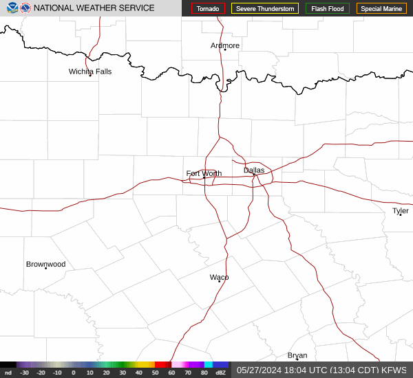
Texas
Tornado Warning
TXC035-217-309-261745-
/O.NEW.KFWD.TO.W.0009.240426T1704Z-240426T1745Z/
BULLETIN - EAS ACTIVATION REQUESTED
Tornado Warning
National Weather Service Fort Worth TX
1204 PM CDT Fri Apr 26 2024
The National Weather Service in Fort Worth has issued a
* Tornado Warning for...
Central McLennan County in central Texas...
Southeastern Bosque County in central Texas...
South central Hill County in central Texas...
* Until 1245 PM CDT.
* At 1204 PM CDT, a severe thunderstorm capable of producing a
tornado was located over Crawford, or near McGregor, moving
northeast at 35 mph.
HAZARD...Tornado.
SOURCE...Radar indicated rotation.
IMPACT...Flying debris will be dangerous to those caught without
shelter. Mobile homes will be damaged or destroyed.
Damage to roofs, windows, and vehicles will occur. Tree
damage is likely.
* This dangerous storm will be near...
Waco around 1210 PM CDT.
Lake Waco around 1215 PM CDT.
Other locations impacted by this tornadic thunderstorm include Rock
Creek, Axtell, Gholson, Willow Grove, Elm Mott, Tours, Wiggins, Ross,
Leroy, and China Spring.
This includes Interstate 35 between mile markers 335 and 352.
PRECAUTIONARY/PREPAREDNESS ACTIONS...
TAKE COVER NOW! Move to an interior room on the lowest floor of a
sturdy building. Avoid windows. If you are outdoors, in a mobile
home, or in a vehicle, move to the closest substantial shelter and
protect yourself from flying debris.
To report severe weather contact your nearest law enforcement agency.
They will send your report to the National Weather Service office in
Fort Worth.
&&
LAT...LON 3160 9756 3182 9731 3183 9712 3171 9692
3171 9693 3165 9689 3142 9748
TIME...MOT...LOC 1704Z 235DEG 30KT 3154 9743
TORNADO...RADAR INDICATED
MAX HAIL SIZE...<.75 IN
$$
Gordon
Tornado Warning
TXC035-217-309-261745-
/O.NEW.KFWD.TO.W.0009.240426T1704Z-240426T1745Z/
BULLETIN - EAS ACTIVATION REQUESTED
Tornado Warning
National Weather Service Fort Worth TX
1204 PM CDT Fri Apr 26 2024
The National Weather Service in Fort Worth has issued a
* Tornado Warning for...
Central McLennan County in central Texas...
Southeastern Bosque County in central Texas...
South central Hill County in central Texas...
* Until 1245 PM CDT.
* At 1204 PM CDT, a severe thunderstorm capable of producing a
tornado was located over Crawford, or near McGregor, moving
northeast at 35 mph.
HAZARD...Tornado.
SOURCE...Radar indicated rotation.
IMPACT...Flying debris will be dangerous to those caught without
shelter. Mobile homes will be damaged or destroyed.
Damage to roofs, windows, and vehicles will occur. Tree
damage is likely.
* This dangerous storm will be near...
Waco around 1210 PM CDT.
Lake Waco around 1215 PM CDT.
Other locations impacted by this tornadic thunderstorm include Rock
Creek, Axtell, Gholson, Willow Grove, Elm Mott, Tours, Wiggins, Ross,
Leroy, and China Spring.
This includes Interstate 35 between mile markers 335 and 352.
PRECAUTIONARY/PREPAREDNESS ACTIONS...
TAKE COVER NOW! Move to an interior room on the lowest floor of a
sturdy building. Avoid windows. If you are outdoors, in a mobile
home, or in a vehicle, move to the closest substantial shelter and
protect yourself from flying debris.
To report severe weather contact your nearest law enforcement agency.
They will send your report to the National Weather Service office in
Fort Worth.
&&
LAT...LON 3160 9756 3182 9731 3183 9712 3171 9692
3171 9693 3165 9689 3142 9748
TIME...MOT...LOC 1704Z 235DEG 30KT 3154 9743
TORNADO...RADAR INDICATED
MAX HAIL SIZE...<.75 IN
$$
Gordon
packyderms_wife
Neither here nor there.
Nebraska
Tornado Warning
NEC093-163-261815-
/O.NEW.KGID.TO.W.0007.240426T1736Z-240426T1815Z/
BULLETIN - EAS ACTIVATION REQUESTED
Tornado Warning
National Weather Service Hastings NE
1236 PM CDT Fri Apr 26 2024
The National Weather Service in Hastings has issued a
* Tornado Warning for...
Eastern Sherman County in central Nebraska...
Northwestern Howard County in central Nebraska...
* Until 115 PM CDT.
* At 1236 PM CDT, a severe thunderstorm capable of producing a
tornado was located over Rockville, or 28 miles northwest of Grand
Island, moving north at 20 mph.
HAZARD...Tornado and half dollar size hail.
SOURCE...Radar indicated rotation.
IMPACT...Flying debris will be dangerous to those caught without
shelter. Mobile homes will be damaged or destroyed.
Damage to roofs, windows, and vehicles will occur. Tree
damage is likely.
* This dangerous storm will be near...
Ashton around 1250 PM CDT.
PRECAUTIONARY/PREPAREDNESS ACTIONS...
TAKE COVER NOW! Move to a basement or an interior room on the lowest
floor of a sturdy building. Avoid windows. If you are outdoors, in a
mobile home, or in a vehicle, move to the closest substantial shelter
and protect yourself from flying debris.
&&
LAT...LON 4117 9869 4106 9876 4110 9896 4139 9888
4139 9856
TIME...MOT...LOC 1736Z 198DEG 18KT 4112 9884
TORNADO...RADAR INDICATED
MAX HAIL SIZE...1.25 IN
$$
Wesely
Tornado Warning
NEC093-163-261815-
/O.NEW.KGID.TO.W.0007.240426T1736Z-240426T1815Z/
BULLETIN - EAS ACTIVATION REQUESTED
Tornado Warning
National Weather Service Hastings NE
1236 PM CDT Fri Apr 26 2024
The National Weather Service in Hastings has issued a
* Tornado Warning for...
Eastern Sherman County in central Nebraska...
Northwestern Howard County in central Nebraska...
* Until 115 PM CDT.
* At 1236 PM CDT, a severe thunderstorm capable of producing a
tornado was located over Rockville, or 28 miles northwest of Grand
Island, moving north at 20 mph.
HAZARD...Tornado and half dollar size hail.
SOURCE...Radar indicated rotation.
IMPACT...Flying debris will be dangerous to those caught without
shelter. Mobile homes will be damaged or destroyed.
Damage to roofs, windows, and vehicles will occur. Tree
damage is likely.
* This dangerous storm will be near...
Ashton around 1250 PM CDT.
PRECAUTIONARY/PREPAREDNESS ACTIONS...
TAKE COVER NOW! Move to a basement or an interior room on the lowest
floor of a sturdy building. Avoid windows. If you are outdoors, in a
mobile home, or in a vehicle, move to the closest substantial shelter
and protect yourself from flying debris.
&&
LAT...LON 4117 9869 4106 9876 4110 9896 4139 9888
4139 9856
TIME...MOT...LOC 1736Z 198DEG 18KT 4112 9884
TORNADO...RADAR INDICATED
MAX HAIL SIZE...1.25 IN
$$
Wesely
packyderms_wife
Neither here nor there.
Texas
packyderms_wife
Neither here nor there.
Texas
Tornado Warning
TXC217-309-261815-
/O.NEW.KFWD.TO.W.0010.240426T1737Z-240426T1815Z/
BULLETIN - EAS ACTIVATION REQUESTED
Tornado Warning
National Weather Service Fort Worth TX
1237 PM CDT Fri Apr 26 2024
The National Weather Service in Fort Worth has issued a
* Tornado Warning for...
Northeastern McLennan County in central Texas...
Southeastern Hill County in central Texas...
* Until 115 PM CDT.
* At 1237 PM CDT, a severe thunderstorm capable of producing a
tornado was located 7 miles northwest of Northcrest, or 7 miles
northwest of Lacy-Lakeview, moving northeast at 35 mph.
HAZARD...Tornado.
SOURCE...Radar indicated rotation.
IMPACT...Flying debris will be dangerous to those caught without
shelter. Mobile homes will be damaged or destroyed.
Damage to roofs, windows, and vehicles will occur. Tree
damage is likely.
* This dangerous storm will be near...
West around 1240 PM CDT.
Other locations impacted by this tornadic thunderstorm include
Malone, Birome, Elm Mott, Mertens, Brandon, Tours, Mount Calm, Irene,
Penelope, and Abbott.
This includes Interstate 35 between mile markers 343 and 362.
PRECAUTIONARY/PREPAREDNESS ACTIONS...
TAKE COVER NOW! Move to an interior room on the lowest floor of a
sturdy building. Avoid windows. If you are outdoors, in a mobile
home, or in a vehicle, move to the closest substantial shelter and
protect yourself from flying debris.
&&
LAT...LON 3174 9730 3174 9728 3175 9728 3178 9733
3207 9696 3205 9694 3207 9690 3181 9672
3162 9720
TIME...MOT...LOC 1737Z 231DEG 30KT 3171 9719
TORNADO...RADAR INDICATED
MAX HAIL SIZE...<.75 IN
$$
Gordon
Tornado Warning
TXC217-309-261815-
/O.NEW.KFWD.TO.W.0010.240426T1737Z-240426T1815Z/
BULLETIN - EAS ACTIVATION REQUESTED
Tornado Warning
National Weather Service Fort Worth TX
1237 PM CDT Fri Apr 26 2024
The National Weather Service in Fort Worth has issued a
* Tornado Warning for...
Northeastern McLennan County in central Texas...
Southeastern Hill County in central Texas...
* Until 115 PM CDT.
* At 1237 PM CDT, a severe thunderstorm capable of producing a
tornado was located 7 miles northwest of Northcrest, or 7 miles
northwest of Lacy-Lakeview, moving northeast at 35 mph.
HAZARD...Tornado.
SOURCE...Radar indicated rotation.
IMPACT...Flying debris will be dangerous to those caught without
shelter. Mobile homes will be damaged or destroyed.
Damage to roofs, windows, and vehicles will occur. Tree
damage is likely.
* This dangerous storm will be near...
West around 1240 PM CDT.
Other locations impacted by this tornadic thunderstorm include
Malone, Birome, Elm Mott, Mertens, Brandon, Tours, Mount Calm, Irene,
Penelope, and Abbott.
This includes Interstate 35 between mile markers 343 and 362.
PRECAUTIONARY/PREPAREDNESS ACTIONS...
TAKE COVER NOW! Move to an interior room on the lowest floor of a
sturdy building. Avoid windows. If you are outdoors, in a mobile
home, or in a vehicle, move to the closest substantial shelter and
protect yourself from flying debris.
&&
LAT...LON 3174 9730 3174 9728 3175 9728 3178 9733
3207 9696 3205 9694 3207 9690 3181 9672
3162 9720
TIME...MOT...LOC 1737Z 231DEG 30KT 3171 9719
TORNADO...RADAR INDICATED
MAX HAIL SIZE...<.75 IN
$$
Gordon

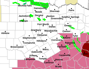
A tornado outbreak appears to be developing.
Two areas of concern, Nebraska and Texas, with multiple tornadoes now on the ground.
Conditions are forecast to deteriorate as the day and the evening progresses.
BOOM!
College of DuPage Meteorology
Severe Weather and Flash Flood Warnings
Note: This page will reload every 2 minutes. Warnings are listed with the most recent first.
Click on the station ID to bring up list of recent severe weather statements.
TORNADO WARNING OMAHA/VALLEY NEBRASKA - KOAX 141 PM CDT FRI APR 26 2024
TORNADO WARNING OMAHA/VALLEY NEBRASKA - KOAX 139 PM CDT FRI APR 26 2024
TORNADO WARNING HASTINGS NE - KGID 138 PM CDT FRI APR 26 2024
TORNADO WARNING FORT WORTH TX - KFWD 132 PM CDT FRI APR 26 2024
SVR T-STORM WARNING OMAHA/VALLEY NEBRASKA - KOAX 129 PM CDT FRI APR 26 2024
SVR T-STORM WARNING HASTINGS NE - KGID 125 PM CDT FRI APR 26 2024
SVR T-STORM WARNING FORT WORTH TX - KFWD 120 PM CDT FRI APR 26 2024
SVR T-STORM WARNING OMAHA/VALLEY NEBRASKA - KOAX 119 PM CDT FRI APR 26 2024
SVR T-STORM WARNING HASTINGS NE - KGID 113 PM CDT FRI APR 26 2024
TORNADO WARNING FORT WORTH TX - KFWD 109 PM CDT FRI APR 26 2024
SVR T-STORM WARNING TOPEKA KS - KTOP 103 PM CDT FRI APR 26 2024
TORNADO WARNING HASTINGS NE - KGID 101 PM CDT FRI APR 26 2024
Last edited:
BULLETIN - EAS ACTIVATION REQUESTED
TORNADO WARNING
NATIONAL WEATHER SERVICE FORT WORTH TX
152 PM CDT FRI APR 26 2024
THE NATIONAL WEATHER SERVICE IN FORT WORTH HAS ISSUED A
* TORNADO WARNING FOR...
SOUTHEASTERN ELLIS COUNTY IN NORTH CENTRAL TEXAS...
NORTHWESTERN NAVARRO COUNTY IN NORTH CENTRAL TEXAS...
* UNTIL 230 PM CDT.
* AT 152 PM CDT, A CONFIRMED TORNADO WAS LOCATED NEAR BARRY, OR 10
MILES WEST OF CORSICANA, MOVING NORTHEAST AT 30 MPH.
HAZARD...DAMAGING TORNADO.
SOURCE...EMERGENCY MANAGEMENT CONFIRMED TORNADO.
IMPACT...FLYING DEBRIS WILL BE DANGEROUS TO THOSE CAUGHT WITHOUT
SHELTER. MOBILE HOMES WILL BE DAMAGED OR DESTROYED.
DAMAGE TO ROOFS, WINDOWS, AND VEHICLES WILL OCCUR. TREE
DAMAGE IS LIKELY.
* THE TORNADO WILL BE NEAR...
BARRY AROUND 155 PM CDT.
ALMA AROUND 210 PM CDT.
OTHER LOCATIONS IMPACTED BY THIS TORNADIC THUNDERSTORM INCLUDE
CHATFIELD, EMHOUSE, AND RICE.
THIS INCLUDES INTERSTATE 45 BETWEEN MILE MARKERS 236 AND 251.
PRECAUTIONARY/PREPAREDNESS ACTIONS...
MOTORISTS SHOULD NOT TAKE SHELTER UNDER HIGHWAY OVERPASSES. IF YOU
CANNOT SAFELY DRIVE AWAY FROM THE TORNADO, AS A LAST RESORT, ABANDON
YOUR VEHICLE AND LIE DOWN IN A LOW LYING AREA AND PROTECT YOURSELF
FROM FLYING DEBRIS.

Storm Prediction Center - Current Convective Watches
Severe weather, tornado, thunderstorm, fire weather, storm report, tornado watch, severe thunderstorm watch, mesoscale discussion, convective outlook products from the Storm Prediction Center.
www.spc.noaa.gov
Walbash
Contributing Member
Ryan Hall is also live again
View: https://www.youtube.com/watch?v=dZDOFX_KEL0
LIVE - Severe Weather Coverage With Storm Chasers On The Ground - Live Weather Channel...
packyderms_wife
Neither here nor there.
Tornado Warning
NEC025-109-155-262015-
/O.NEW.KOAX.TO.W.0015.240426T1931Z-240426T2015Z/
BULLETIN - EAS ACTIVATION REQUESTED
Tornado Warning
National Weather Service Omaha/Valley Nebraska
231 PM CDT Fri Apr 26 2024
The National Weather Service in Omaha has issued a
* Tornado Warning for...
Northern Lancaster County in southeastern Nebraska...
South central Saunders County in east central Nebraska...
West central Cass County in southeastern Nebraska...
* Until 315 PM CDT.
* At 231 PM CDT, a severe thunderstorm capable of producing a tornado
was located over Pioneers Park, or 4 miles southwest of Lincoln,
moving northeast at 30 mph.
HAZARD...Tornado and ping pong ball size hail.
SOURCE...Radar indicated rotation.
IMPACT...Flying debris will be dangerous to those caught without
shelter. Mobile homes will be damaged or destroyed.
Damage to roofs, windows, and vehicles will occur. Tree
damage is likely.
* This dangerous storm will be near...
Lincoln, Lincoln Airport, and Pioneers Park around 235 PM CDT.
Other locations in the path of this tornadic thunderstorm include
Davey and Ceresco.
PRECAUTIONARY/PREPAREDNESS ACTIONS...
TAKE COVER NOW! Move to a basement or an interior room on the lowest
floor of a sturdy building. Avoid windows. If you are outdoors, in a
mobile home, or in a vehicle, move to the closest substantial shelter
and protect yourself from flying debris.
&&
LAT...LON 4070 9676 4076 9691 4114 9673 4102 9638
TIME...MOT...LOC 1931Z 204DEG 28KT 4077 9676
TORNADO...RADAR INDICATED
MAX HAIL SIZE...1.50 IN
$$
McCoy
- Status
- Not open for further replies.