
You are using an out of date browser. It may not display this or other websites correctly.
You should upgrade or use an alternative browser.
You should upgrade or use an alternative browser.
WEATHER Severe Weather the Week of March 4th, 2024
- Thread starter packyderms_wife
- Start date

packyderms_wife
Neither here nor there.
Current Map | U.S. Drought Monitor.
US Drought Report, it's an interactive map.

 www.fireweatheravalanche.org
Wildfire map... never thought I'd be posting this one weekly.
www.fireweatheravalanche.org
Wildfire map... never thought I'd be posting this one weekly. 

 www.star.nesdis.noaa.gov
GOES Sat imagery... it's currently offline for maintenance... you can select different filter views, for dust, smoke, ash, etc
www.star.nesdis.noaa.gov
GOES Sat imagery... it's currently offline for maintenance... you can select different filter views, for dust, smoke, ash, etc
US Drought Report, it's an interactive map.
FWAC Wildfire Map - Current Wildfires, Forest Fires, and Lightning Strikes near you | Fire, Weather & Avalanche Center
Interactive real-time wildfire map for the United States, including California, Oregon, Washington, Idaho, Arizona, and others. See current wildfires and wildfire perimeters near you using the Fire, Weather & Avalanche Center Wildfire Map.
GOES Imagery Viewer - NOAA / NESDIS / STAR
Near real-time publication of GOES-East and GOES-West images from NOAA/NESDIS/STAR
packyderms_wife
Neither here nor there.
RT 8:57 - Max Velocity
In this weather forecast, we are breaking down MULTIPLE STORMS that will bring the potential for some severe weather next week and record-breaking high temperatures from the Midwest into the Great Plains! Additionally, we will briefly discuss the significant snow event that is happening California, and why some areas will see as much as 140" of snow! This winter heatwave will impact areas like the Southern Plains, Mississippi Valley, Midwest, and Ohio Valley. Find the latest details of the weather across the United States in our latest weather forecast.
Today

packyderms_wife
Neither here nor there.
Wind Speeds in Iowa Today.

packyderms_wife
Neither here nor there.
RT 9:13 - Max Velocity
In this weather forecast, we are breaking down TWO STORMS that will bring the potential for some severe weather this week and record-breaking high temperatures from the Midwest into the Great Plains! This winter heatwave will impact areas like the Southern Plains, Mississippi Valley, Midwest, and Ohio Valley. Find the latest details of the weather across the United States in our latest weather forecast
pauldingbabe
The Great Cat


packyderms_wife
Neither here nor there.
It rained here, finally, in central Iowa this morning. Not for long but long enough to beat the dust back a little bit.
Potential for isolated severe weather increasing.
It's 47F in Milwaukee and 66F in Chicago currently.
Fairly strong warm front pushing into the WI/IL border.

Mesoscale Discussion 0189
NWS Storm Prediction Center Norman OK
0125 PM CST Mon Mar 04 2024
Areas affected...Northeast Missouri to northern Illinois and
southern Wisconsin
Concerning...Severe potential...Watch unlikely
Valid 041925Z - 042130Z
Probability of Watch Issuance...20 percent
SUMMARY...Additional thunderstorm development is expected along and
just ahead of cold front from southern Wisconsin into eastern Iowa,
northwest Illinois, and northeast Missouri in the next 1-3 hours.
Thunderstorms will primarily pose a damaging wind and severe hail
risk.
DISCUSSION...Gradual destabilization is ongoing across portions of
MO/IA/IL as temperatures climb into the low to mid 70s amid broken
cloud cover and continued northward moisture return. Recent
temperature/dewpoint observations are higher than anticipated by
recent guidance by as much as a few degrees, suggesting that MLCIN
is likely eroding slightly faster than depicted by guidance and/or
mesoanalyses. Satellite imagery bears this out with slowly deepening
cumulus developing from northeast MO to western IL and a recent
intensification of previously anemic convection along the IA/IL
border. High-res guidance suggests additional convection is likely
in the next couple of hours along and ahead of the cold front, but
the aforementioned observed trends hint at the potential for earlier
initiation.
Regardless of precise timing, initially semi-discrete cells should
undergo upscale growth owing to strengthening forcing for ascent and
undercutting nature of the front, as well as mean storm motion and
deep-layer shear vectors oriented northeast along the boundary.
Consequently, an initial hail threat should transition to a damaging
wind threat threat heading into the late afternoon hours and with
eastward extent. Poor boundary-normal deep-layer shear should limit
overall storm organization/intensity. A low-end tornado threat may
materialize across northern IL where backed low-level flow in the
vicinity of the warm front may locally enhance effective SRH.
However, this may be conditional on realizing at least a
semi-discrete storm mode. Additionally, the northward extent of the
warm sector into southern WI is uncertain given extensive cloud
cover and falling temperatures north of the surface warm front.
Given these concerns, watch issuance is not anticipated.
..Moore/Hart.. 03/04/2024
...Please see www.spc.noaa.gov for graphic product...
It's 47F in Milwaukee and 66F in Chicago currently.
Fairly strong warm front pushing into the WI/IL border.
Mesoscale Discussion 0189
NWS Storm Prediction Center Norman OK
0125 PM CST Mon Mar 04 2024
Areas affected...Northeast Missouri to northern Illinois and
southern Wisconsin
Concerning...Severe potential...Watch unlikely
Valid 041925Z - 042130Z
Probability of Watch Issuance...20 percent
SUMMARY...Additional thunderstorm development is expected along and
just ahead of cold front from southern Wisconsin into eastern Iowa,
northwest Illinois, and northeast Missouri in the next 1-3 hours.
Thunderstorms will primarily pose a damaging wind and severe hail
risk.
DISCUSSION...Gradual destabilization is ongoing across portions of
MO/IA/IL as temperatures climb into the low to mid 70s amid broken
cloud cover and continued northward moisture return. Recent
temperature/dewpoint observations are higher than anticipated by
recent guidance by as much as a few degrees, suggesting that MLCIN
is likely eroding slightly faster than depicted by guidance and/or
mesoanalyses. Satellite imagery bears this out with slowly deepening
cumulus developing from northeast MO to western IL and a recent
intensification of previously anemic convection along the IA/IL
border. High-res guidance suggests additional convection is likely
in the next couple of hours along and ahead of the cold front, but
the aforementioned observed trends hint at the potential for earlier
initiation.
Regardless of precise timing, initially semi-discrete cells should
undergo upscale growth owing to strengthening forcing for ascent and
undercutting nature of the front, as well as mean storm motion and
deep-layer shear vectors oriented northeast along the boundary.
Consequently, an initial hail threat should transition to a damaging
wind threat threat heading into the late afternoon hours and with
eastward extent. Poor boundary-normal deep-layer shear should limit
overall storm organization/intensity. A low-end tornado threat may
materialize across northern IL where backed low-level flow in the
vicinity of the warm front may locally enhance effective SRH.
However, this may be conditional on realizing at least a
semi-discrete storm mode. Additionally, the northward extent of the
warm sector into southern WI is uncertain given extensive cloud
cover and falling temperatures north of the surface warm front.
Given these concerns, watch issuance is not anticipated.
..Moore/Hart.. 03/04/2024
...Please see www.spc.noaa.gov for graphic product...
Only a sprinkle here (NW Iowa) not enough to wet the sidewalk let alone settle the dust.
My neighbor has five ash trees that need to come down. A section of one ash came down in last big wind a week ago. Last night his beautiful birch came down on a vehicle. No damage but a sad loss. I was thinking it was too bad one of the ash trees didn't come down, but on second thought those are bigger and probably would have hit his house.
My neighbor has five ash trees that need to come down. A section of one ash came down in last big wind a week ago. Last night his beautiful birch came down on a vehicle. No damage but a sad loss. I was thinking it was too bad one of the ash trees didn't come down, but on second thought those are bigger and probably would have hit his house.
Tornado on the ground live now!
Near IL/WI border approaching Beloit.
No official warnings yet.
View: https://youtu.be/9tdtAdboUmc
Near IL/WI border approaching Beloit.
No official warnings yet.
BREAKING - Tornado On The Ground In Illinois - Tornadoes, Damaging Winds - With Live Storm Chaser

packyderms_wife
Neither here nor there.
Tornado Warning
WIC105-042145-
/O.NEW.KMKX.TO.W.0006.240304T2110Z-240304T2145Z/
BULLETIN - EAS ACTIVATION REQUESTED
Tornado Warning
National Weather Service Milwaukee/Sullivan WI
310 PM CST Mon Mar 4 2024
The National Weather Service in Milwaukee/Sullivan has issued a
* Tornado Warning for...
Southeastern Rock County in south central Wisconsin...
* Until 345 PM CST.
* At 308 PM CST, a severe thunderstorm capable of producing a tornado
was located near Rockton, moving northeast at 35 mph.
HAZARD...Tornado.
SOURCE...Radar indicated rotation.
IMPACT...Flying debris will be dangerous to those caught without
shelter. Mobile homes will be damaged or destroyed.
Damage to roofs, windows, and vehicles will occur. Tree
damage is likely.
* Locations impacted include...
Janesville, Beloit, South Beloit, Clinton, Newark, Tiffany,
Foxhollow, Afton, and Shopiere.
PRECAUTIONARY/PREPAREDNESS ACTIONS...
TAKE COVER NOW! Move to a basement or an interior room on the lowest
floor of a sturdy building. Avoid windows. If you are outdoors, in a
mobile home, or in a vehicle, move to the closest substantial shelter
and protect yourself from flying debris.
&&
LAT...LON 4250 8932 4273 8897 4253 8877 4253 8878
4249 8890
TIME...MOT...LOC 2108Z 231DEG 29KT 4249 8919
TORNADO...RADAR INDICATED
MAX HAIL SIZE...<.75 IN
$$
PATTERSON
packyderms_wife
Neither here nor there.
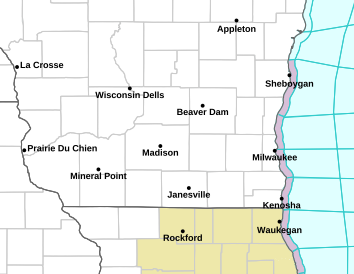
IL/WI border

adgal
Veteran Member
We received quite a bit of rain and hail about an hour ago. Hail was dime-sized. Rain puddled in the backyard. Tornado sirens went off in the next town - and a spotter reported a tornado just southwest of us. It's still rumbling outside, and we're supposed to get more rain until midnight.
packyderms_wife
Neither here nor there.
Tornado Warning
ILC015-195-042315-
/O.NEW.KDVN.TO.W.0006.240304T2228Z-240304T2315Z/
BULLETIN - EAS ACTIVATION REQUESTED
Tornado Warning
National Weather Service Quad Cities IA/IL
428 PM CST Mon Mar 4 2024
The National Weather Service in the Quad Cities has issued a
* Tornado Warning for...
Northeastern Whiteside County in northwestern Illinois...
Southeastern Carroll County in northwestern Illinois...
* Until 515 PM CST.
* At 427 PM CST, a severe thunderstorm capable of producing a tornado
was located over Whiteside County Fairgrounds, or over Morrison,
moving northeast at 40 mph.
HAZARD...Tornado and hail up to two inches in diameter.
SOURCE...Radar indicated rotation.
IMPACT...Flying debris will be dangerous to those caught without
shelter. Mobile homes will be damaged or destroyed.
Damage to roofs, windows, and vehicles will occur. Tree
damage is likely.
* This dangerous storm will be near...
Sterling, Rock Falls, Coleta, Emerson, Round Grove, Agnew, Douglas
Park, Como, Malvern, and Galt around 435 PM CST.
Whiteside County Airport and Penrose around 445 PM CST.
This includes Interstate 88 between mile markers 21 and 41.
PRECAUTIONARY/PREPAREDNESS ACTIONS...
TAKE COVER NOW! Move to a basement or an interior room on the lowest
floor of a sturdy building. Avoid windows. If you are outdoors, in a
mobile home, or in a vehicle, move to the closest substantial shelter
and protect yourself from flying debris.
Motorists should not take shelter under highway overpasses. If you
cannot safely drive away from the tornado, as a last resort, either
park your vehicle and stay put, or abandon your vehicle and lie down
in a low lying area and protect yourself from flying debris.
&&
LAT...LON 4168 9004 4176 9009 4198 8969 4193 8969
4193 8963 4176 8963
TIME...MOT...LOC 2227Z 242DEG 33KT 4177 8997
TORNADO...RADAR INDICATED
MAX HAIL SIZE...2.00 IN
$$
Gunkel
Lookin' kinda sporty in Illanoy, Wisconsin and Michigan.
Storm chasers are congregating.
Lotsa lightning on the storm scope.
No boxes up yet.

 zoomradar.com

Storm chasers are congregating.
Lotsa lightning on the storm scope.
No boxes up yet.
ZoomRadar – Interactive Weather For Your Website
ZoomRadar is one of the fastest updating interactive radars on the web, aggregating local Level 2 Doppler radars from all across the US
packyderms_wife
Neither here nor there.
RT 8:15 - Ryan Hall y'all xtra
In this video we are talking about severe weather and an upcoming weather flip flop pattern change…
packyderms_wife
Neither here nor there.

US National Weather Service Des Moines Iowa
How dry are we as we approach spring? Here's a look at the 0-100cm Soil Moisture Percentile which compares current conditions to the climatological norms. Red and orange colors indicate soils that are more dry.Luckily, beneficial rain is on the way later this week.

packyderms_wife
Neither here nor there.
RT 8:34 - Max Velocity
In this weather forecast, we are breaking down a HUGE STORM that will bring the potential for severe weather this week from the Southern Plains into the Dixie Alley! This will bring the threat of damaging winds, large hail, and tornadoes. Additionally, the "winter heat wave" will continue to stick around this week. This winter heatwave will impact areas like the Southern Plains, Mississippi Valley, Midwest, and Ohio Valley. Find the latest details of the weather across the United States in our latest weather forecast.
Storm chasers are stacked up south of Wichita KS. into OK, 6 of them for now. Per Zoomradar.
zoomradar.com
Not really anything interesting on the radar, but I bet there will be soon.
A few more and different ones showing on Live Storm Chasing.
 livestormchasing.com
ZoomRadar – Interactive Weather For Your Website
ZoomRadar is one of the fastest updating interactive radars on the web, aggregating local Level 2 Doppler radars from all across the US
Not really anything interesting on the radar, but I bet there will be soon.
A few more and different ones showing on Live Storm Chasing.
Live Storm Chasing
Watch live feeds as storm chasers try to see if their target verifies. Tornadoes, hurricanes, blizzards, and floods - we've got it all and more, live on our site and available as video on demand.
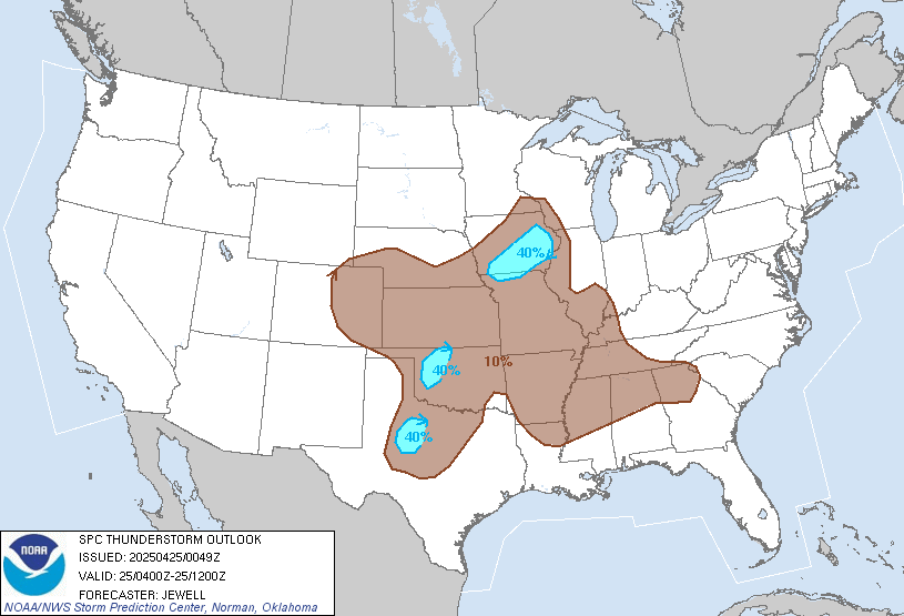
Severe T-storm watches up.
A herd of storm chasers stacked up....that's a bad sign.
A herd of storm chasers stacked up....that's a bad sign.
packyderms_wife
Neither here nor there.
I need to go rest, stay safe everyone.
homecanner1
Veteran Member
saw a tiktok vid the other day of 20something gal asking if our traditional map of tornado alley is shifting east due to drought out west. Went looking and found these two.

This would explain the uptick of activity in Iowa since the Derecho flattened all the corn that year.
A modern interpretation of Tornado Alley as of 2022:


This would explain the uptick of activity in Iowa since the Derecho flattened all the corn that year.
A modern interpretation of Tornado Alley as of 2022:
Watch possible,

Mesoscale Discussion 0204
NWS Storm Prediction Center Norman OK
0920 AM CST Fri Mar 08 2024
Areas affected...East TX into central/southern LA and southwest MS
Concerning...Severe potential...Watch possible
Valid 081520Z - 081715Z
Probability of Watch Issuance...40 percent
SUMMARY...Some uptick in severe potential is possible through the
morning. Hail, damaging gusts, and a tornado or two will become
possible with time. Eventual watch issuance is possible, though
timing is uncertain.
DISCUSSION...Extensive convection is ongoing this morning from parts
of east TX into LA. A convectively reinforced surface front is
draped from northeast TX into northern LA and west-central MS. To
the south of the front, rich low-level moisture is in place, with
dewpoints in the upper 60s/low 70s F. Widespread cloudiness will
tend to limit diurnal heating through the morning, but modestly
steep midlevel lapse rates atop the moist boundary layer will
support MLCAPE of 1000-1500 J/kg through the morning, helping to
maintain convection as it generally spreads eastward.
Deep-layer shear is favorable for organized convection across the
region, though storms may struggle to mature due to the lack of
stronger heating and generally weak low-level lapse rates.
Eventually, a couple supercells may become established from east TX
into LA and perhaps southwest MS, posing a threat of hail and
locally damaging gusts. If supercells can be sustained, a tornado or
two will also be possible, especially from central/eastern LA into
southwest MS, where some airmass recovery is expected in the wake of
an earlier storm cluster, and 0-1 km SRH of 100-200 m2/s2 is
expected to persist through much of the day.
Watch issuance will become possible if the threat for maturing
supercells appears imminent, though the onset of a greater threat
and potential watch timing remain uncertain.
..Dean/Smith.. 03/08/2024
Will auto-update.

packyderms_wife
Neither here nor there.
Tornado Warning
MSC073-091-082315-
/O.NEW.KJAN.TO.W.0008.240308T2209Z-240308T2315Z/
BULLETIN - EAS ACTIVATION REQUESTED
Tornado Warning
National Weather Service Jackson MS
409 PM CST Fri Mar 8 2024
The National Weather Service in Jackson has issued a
* Tornado Warning for...
Southeastern Marion County in south central Mississippi...
Central Lamar County in southeastern Mississippi...
* Until 515 PM CST.
* At 409 PM CST, a severe thunderstorm capable of producing a tornado
was located over Pine Burr, or 11 miles southeast of Columbia,
moving east at 40 mph.
HAZARD...Tornado.
SOURCE...Radar indicated rotation.
IMPACT...Flying debris will be dangerous to those caught without
shelter. Mobile homes will be damaged or destroyed.
Damage to roofs, windows, and vehicles will occur. Tree
damage is likely.
* This dangerous storm will be near...
Baxterville and Pine Burr around 415 PM CST.
Purvis and Pine Ridge around 425 PM CST.
Hattiesburg around 430 PM CST.
Oak Grove around 435 PM CST.
West Hattiesburg around 445 PM CST.
PRECAUTIONARY/PREPAREDNESS ACTIONS...
TAKE COVER NOW! Move to a basement or an interior room on the lowest
floor of a sturdy building. Avoid windows. If you are outdoors, in a
mobile home, or in a vehicle, move to the closest substantial shelter
and protect yourself from flying debris.
&&
LAT...LON 3105 8977 3115 8979 3135 8935 3110 8935
TIME...MOT...LOC 2209Z 251DEG 34KT 3110 8972
TORNADO...RADAR INDICATED
MAX HAIL SIZE...<.75 IN
$$
86
packyderms_wife
Neither here nor there.
Mississippi

packyderms_wife
Neither here nor there.
LIVE STREAM - Max Velocity