
You are using an out of date browser. It may not display this or other websites correctly.
You should upgrade or use an alternative browser.
You should upgrade or use an alternative browser.
Solar The Grand Solar Minimum (ORIGINAL)
- Thread starter von Koehler
- Start date
-
- Tags
- grand solar minimum
- Status
- Not open for further replies.
BenIan
Veteran Member
RT 2:44
Alert level raised to 4, explosive eruption likely, mandatory evacuation
TxGal
Day by day
Diamond will be all over this.
I bet he will! Lots of videos out there this morning, most not in English, but the images are just amazing. This has got to affect the weather.
TxGal
Day by day
Taal Volcano near Manila, Philippines erupts for first time in 50 years - Onlookers stunned by electric display -- Sott.net
Comment: ANOTHER erupting volcano 'goes electric'! It's hard to believe now because it's common in these strange times, but the sight of lightning being emitted from an erupting volcano was once folklore... The Philippines' Taal volcano has...
 www.sott.net
Taal Volcano near Manila, Philippines erupts for first time in 50 years - Onlookers stunned by electric display
RT
Sun, 12 Jan 2020 12:24 UTC
Comment: ANOTHER erupting volcano 'goes electric'! It's hard to believe now because it's common in these strange times, but the sight of lightning being emitted from an erupting volcano was once folklore...
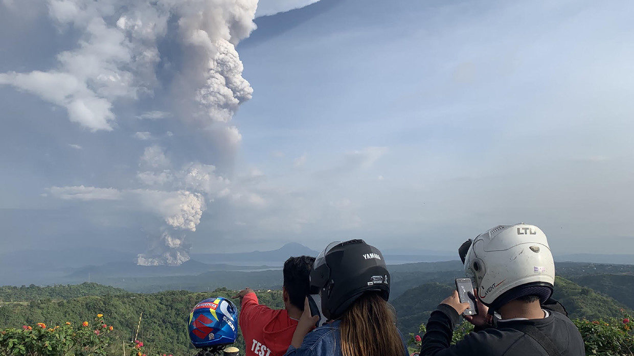
© AFP / Bullit Marquez
People take photos of the Taal volcano as seen from the town of Tagaytay in Cavite province, southwest of Manila, on January 12, 2020.
The Philippines' Taal volcano has erupted, spewing a large column of ash which prompted raised alert levels and the evacuation of nearby communities. Making the sight even more menacing, lightning was seen hitting the ash plume.
The eruption began on Sunday and was caught on video by numerous bystanders, as well as surveillance cameras used to monitor the volcano. While Taal has been quiet since 1977, when the last major eruption occurred, it has been exhibiting increased seismic activity over the past few years.
The initial eruption is described as phreatic - meaning it occurs when heated magma evaporates ground or surface water.
View: https://twitter.com/TaeTaeHart/status/1216265367955238913
The plume darkened shortly afterwards, indicating that the steam was joined by actual volcanic ash.
As if footage of the eruption didn't already look menacing enough, several lightning strikes have been observed in the area. The lightning bolts were seen hitting the center of the ash column which is towering over the volcano.
View: https://twitter.com/sy_franche/status/1216310256478744576
As well as 'enjoying' a doomsday view, nearby communities have experienced an ashfall shortly after the eruption.
The eruption has prompted the evacuation of people living in the immediate vicinity of the volcano, with some 8,000 locals affected. Communities on the shores of the Taal lake were told to watch out for potential water disturbances and high waves that might be created by the increased seismic activity.
View: https://twitter.com/inquirerdotnet/status/1216303271205208064
The spike in the mountain's activities prompted the Philippine Institute of Volcanology and Seismology (PHIVOLCS) to upgrade its threat level twice within an hour. The alert level skyrocketed from 'abnormal' to 'magmatic unrest,' suggesting that the volcano might even spew some lava.
The complex volcano rises from the waters of its namesake lake, featuring a number of craters. Its largest crater has a small lake of its own.
View: https://twitter.com/MIAAGovPH/status/1216305661660692480
The Taal belongs to the so-called 'Decade Volcanos' - 16 mountains known for violent and deadly eruptions in the past and therefore considered worthy of close study and monitoring. The greatest recorded eruption of the Taal occurred back in 1754 and lasted for nearly eight months.
The deadliest eruption occurred in 1911, claiming the lives of over 1,300 people and effectively wiping out all human settlements on the volcanic island.
TxGal
Day by day

Taal volcano (Luzon, Philippines) activity update: Significant eruption, first in 43 years, Alert Level raised to 4
Taal volcano (Philippines): news & activity updates
www.volcanodiscovery.com
Taal volcano news & activity updates
Taal volcano (Luzon, Philippines) activity update: Significant eruption, first in 43 years, Alert Level raised to 4
Sunday Jan 12, 2020 14:54 PM | BY: MJFLEGEND

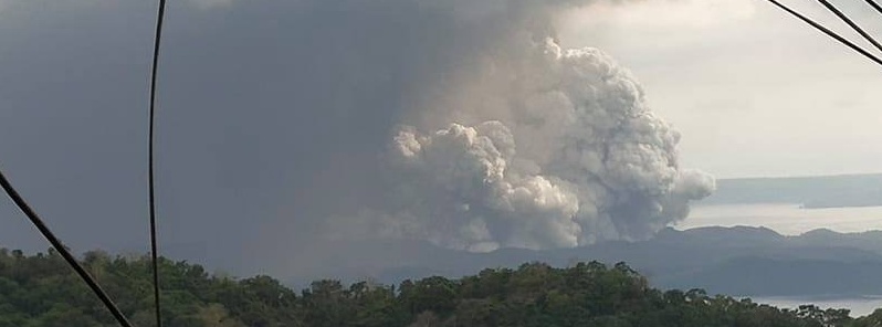
Spectacular view of the eruption from Batangas. Credit: Domcar Lagto

Steam-rich eruption plume. Credit: Danny Ocampo.

View of the main crater. Credit: Thelma Dumpit.
Taal is erupting for the first time since 1977, and has sent a steam-and-ash plume to 16.8km (55,000ft), accompanied by a lot of lightning. PHIVOLCS has raised the Alert Level to 4 on a scale of 0-5. It is currently unknown whether the eruption is phreatic or phreatomagmatic.
Taal is an extremely dangerous volcano that has the potential to produce massive base surges and tsunami waves in the lake, as in the last major eruption in 1965; there is a 14km exclusion zone around the main crater in place.
Numerous flights have been cancelled and significant widespread ashfall (described as a "brownout") is causing much disruption, with power outages reported.
- All news about: Taal volcano
- Information about: Taal volcano
Links / Sources:
Melodi
Disaster Cat
Just caught up here a bit, the two volcanic eruptions are likely to have an impact at least on climate for the next year or two, especially the one in the Philippines.
Mark Armstrong has some points but my goodness anyone and pretty much everyone with the slightest interest in Viking Studies, The Migration/Dark Ages or even Charlamenge knows about the Medieval Warming period that allowed for the European expansions into Iceland, Greenland, and Vinland.
Not as many people are family with the extremely cold period right before it (or the years the sun didn't shine) in the 530s, but again, almost anyone that studies that history all (or does good reenactment) can talk you head off about the warming period and then its collapse in the early 14th century.
That led to famine so horrific that people in Europe thought God had abandoned the planet and that was a generation BEFORE the Black Death.
But he really does need to realize that while John Q. Public may not know about the Norse and warm weather for sailing, anyone who is remotely interested in the topic is aware of it - without there would probably not even have been colonization of Iceland.
As it was, it was nearly abandoned during the Solar Minimum period when the Sea Ice cut them off for an entire year from the rest of Europe, it was nearly abandoned again in the 18th century but that was a giant volcanic eruption (the one that caused A Year Without a Summer).
TxGal
Day by day
UPDATED INFO:
The Grand Solar Minimum News has a podcast on the Taal volcanic eruption:
View: https://www.youtube.com/watch?v=tZK0REtXRrI
Powerful eruption at Taal volcano, volcanic ash to 16.7 km (55 000 feet)
Run time is 36:39
Taal volcano in the Philippines started erupting at 06:04 UTC on January 12, 2020, for the first time since 1977. The volcanic ash cloud is reaching up to 16.7 km (55 000 feet) above sea level, according to data provided by the Tokyo VAAC.
https://watchers.news/2020/01/12/powe...
#GSM #grandsolarminimum
The Grand Solar Minimum News has a podcast on the Taal volcanic eruption:
Powerful eruption at Taal volcano, volcanic ash to 16.7 km (55 000 feet)
Run time is 36:39
Taal volcano in the Philippines started erupting at 06:04 UTC on January 12, 2020, for the first time since 1977. The volcanic ash cloud is reaching up to 16.7 km (55 000 feet) above sea level, according to data provided by the Tokyo VAAC.
https://watchers.news/2020/01/12/powe...
#GSM #grandsolarminimum
Last edited:
TxGal
Day by day
Powerful eruption at Taal volcano, volcanic ash to 16.7 km (55 000 feet) a.s.l., Philippines
Taal volcano in the Philippines started erupting at 06:04 UTC on January 12, 2020, for the first time since 1977. The volcanic ash cloud is reaching up to 16.7 km (55 000 feet) above sea level…
 watchers.news
Powerful eruption at Taal volcano, volcanic ash to 16.7 km (55 000 feet) a.s.l., Philippines
Posted by Teo Blašković on January 12, 2020 at 09:48 UTC (7 hours ago)
Categories: Featured articles, Volcanoes
 a.s.l., Philippines")
Taal volcano in the Philippines started erupting at 06:04 UTC on January 12, 2020, for the first time since 1977. The volcanic ash cloud is reaching up to 16.7 km (55 000 feet) above sea level, according to data provided by the Tokyo VAAC.
- PHIVOLCS said it strongly recommends Taal Volcano Island and high-risk barangays of Agoncillo and Laurel, Batangas be evacuated due to the possible hazards of pyroclastic density currents and volcanic tsunami.
- Tall has produced some of the Philippines' most powerful eruptions. Powerful pyroclastic flows and surges from historical eruptions have caused many fatalities. Its last eruption took place in 1977 (VEI2).
At 09:00 UTC, the Tokyo VAAC reported it has updated volcanic ash height to 16.7 km (55 000 feet) a.s.l. based on satellite data (08:20 UTC) and numerical weather prediction.

View: https://twitter.com/seokjanekook/status/1216274159010869249
View: https://twitter.com/chematierra/status/1216387927837741056
Taal volcano seismic network has manifested moderate to high level of seismic activity since March 28, 2019. Some of these earthquakes were felt with intensity ranging from Intensity I (Scarcely Perceptible) to Intensity III (Weak Shaking) in the barangays of Calauit, Balete, Sitio Tibag, Pira-Piraso, and Buco, Talisay, Alas-as and Pulangbato, San Nicolas, Batangas. Often, these felt earthquakes are accompanied by rumbling sounds.
Three felt earthquake were recorded over the past 12 hours - at 23:35 UTC on January 11, 02:43 and 06:00 UTC on January 12.
A seismic swarm has started at around 03:00 UTC (11:00 LT).
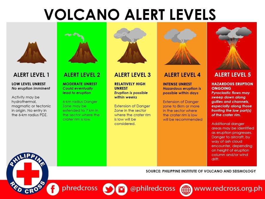
PHIVOLCS raised the Alert Level at 08:00 UTC to 3 - this means that there is a magmatic intrusion that is likely driving the current activity.
The Institute said it strongly recommends Taal Volcano Island and high-risk barangays of Agoncillo and Laurel, Batangas be evacuated due to the possible hazards of pyroclastic density currents and volcanic tsunami.
The public is reminded that the entire Volcano Island is a Permanent Danger Zone (PDZ), and entry into the island as well as high-risk barangays of Agoncillo and Laurel is prohibited.
In addition, communities around the Taal Lake shore are advised to take precautionary measures and be vigilant of possible lakewater disturbances related to the ongoing unrest.
There are many podcasts/tweets/facebook postings on this website that I can't bring over; please go to the link to see them.
Update:
PHIVOLCS raised the Alert Level from 3 (magmatic unrest) to 4 (hazardous eruption imminent) at 11:30 UTC. This means that hazardous explosive eruption is possible within hours to days.
DOST-PHIVOLCS strongly reiterates total evacuation of Taal Volcano Island and additional evacuation of areas at high risk to pyroclastic density currents and volcanic tsunami within a 14 km (8.7 miles) radius from Taal Main Crater.
Areas in the general north of Taal Volcano are advised to guard against the effects of heavy and prolonged ashfall. Civil aviation authorities must advise aircraft to avoid the airspace around Taal Volcano as airborne ash and ballistic fragments from the eruption column pose hazards to aircraft.
As of 09:30 UTC (17:30 LT), eruptive activity at Taal Volcano Main Crater intensified as continuous eruption generated a tall 10-15 km (33 000 - 49 000 feet) steam-laden tephra column with frequent volcanic lightning that rained wet ashfall on the general north as far as Quezon City, PHIVOLCS reported.
Volcanic tremor was recorded continuously since 03:00 UTC and two volcanic earthquakes of magnitudes M2.5 and M3.9 were felt at Intensity III in Tagaytay City and Alitagtag, Batangas were recorded at 10:15 and 10:22 UTC (18:15 and 18:22 PST), respectively.
Ashfall was reported in Metro Manilla (100 km / 62 miles) N of Taal.
All flights at Ninoy Aquino International Airport are on a delay, and passengers advised to coordinate with airlines for updates.
Evacuations are underway in the municipalities of San Nicolas, Balete and Talisay.
Classes within the provinces of Cavite, Batangas, Rizal and Laguna will be canceled on Monday, Januar 13. due to heavy ashfall.
Manila City Mayor Isko Moreno has also ordered the suspension of classes in all levels of public and private schools on Monday.
"Magma is intruding from below. If eventually this will continue to move up, then there can be a magmatic eruption which is more dangerous," PHIVOLCS head Renato Soldium said.
Geological summary
Taal is one of the most active volcanoes in the Philippines and has produced some of its most powerful historical eruptions. Though not topographically prominent, its prehistorical eruptions have greatly changed the topography of SW Luzon. The 15 x 20 km (9 x 12 feet) Talisay (Taal) caldera is largely filled by Lake Taal, whose 267 km2 (103 mi2) surface lies only 3 m (9.8 feet) above sea level.
The maximum depth of the lake is 160 m (525 feet), and several eruptive centers lie submerged beneath the lake. The 5-km-wide (3.1 miles) Volcano Island in north-central Lake Taal is the location of all historical eruptions. The island is composed of coalescing small stratovolcanoes, tuff rings, and scoria cones that have grown about 25% in the area during historical time. Powerful pyroclastic flows and surges from historical eruptions have caused many fatalities.
Martinhouse
Deceased
Am anxious to see what DuByne has to say about this one!
TxGal
Day by day
Am anxious to see what DuByne has to say about this one!
So am I! I really expect him to stress what he said before about dropping everything and going out to buy food. It will be interesting.
Martinhouse
Deceased
He said to drop everything, stop by your bank and draw out every penny, and go buy food!
Right now I'm trying to figure out what food that might be. I don't think I have room for any more food!
What I'd prefer to do is get all the seeds, sets and plants for the coming gardening season, but we don't get those here until late February for potatoes, onions and then cabbage and related plants. Then at least well into March for other plants.
I wouldn't mind having a couple dozen more patio blocks, but I can't go anywhere until I get those ten sacks of feed out of the back of my truck. I should probably see to that tomorrow...the ground ought to be dry enough for the wagon by then.
Martinhouse
Deceased
Diamond just put up a short podcast about the volcano. Runs 5:21
He called it a VEI4 and also said it is ongoing, so I'm thinking he'll have more for us later.
He said the bigger blast sent as to 55,000 feet, which could lower the temp by .2 degree C.
Nothing yet from DuByne or IAF. GSM Channel will have something about it around 8 PM.
WOW!
He called it a VEI4 and also said it is ongoing, so I'm thinking he'll have more for us later.
He said the bigger blast sent as to 55,000 feet, which could lower the temp by .2 degree C.
Nothing yet from DuByne or IAF. GSM Channel will have something about it around 8 PM.
WOW!
TxGal
Day by day
Thanks Martinhouse! The Alert Level is a 4....I think this is going to be a VEI 5 (if not a 6)
Here's Diamond's podcast:
View: https://www.youtube.com/watch?v=Mz_3O8JCHCo
Taal Volcano, Philippines Electric Eruption: First In 43 Years, Alert Level Raised To 4
Run time is 5:20
Taal is erupting for the first time since 1977, and has sent a steam-and-ash plume to 16.8km (55,000ft), accompanied by a lot of lightning. PHIVOLCS has raised the Alert Level to 4 on a scale of 0-5. It is currently unknown whether the eruption is phreatic or phreatomagmatic. http://bit.ly/2TjlxH5
Taal Volcano erupts in Philippines https://cnn.it/36LvjFT
Timelapse of Taal Volcano spewing ash http://bit.ly/2Tgfbs8 Taal volcano ejects smoke and ash, villagers flee http://bit.ly/2FJ3imC
Here's Diamond's podcast:
Taal Volcano, Philippines Electric Eruption: First In 43 Years, Alert Level Raised To 4
Run time is 5:20
Taal is erupting for the first time since 1977, and has sent a steam-and-ash plume to 16.8km (55,000ft), accompanied by a lot of lightning. PHIVOLCS has raised the Alert Level to 4 on a scale of 0-5. It is currently unknown whether the eruption is phreatic or phreatomagmatic. http://bit.ly/2TjlxH5
Taal Volcano erupts in Philippines https://cnn.it/36LvjFT
Timelapse of Taal Volcano spewing ash http://bit.ly/2Tgfbs8 Taal volcano ejects smoke and ash, villagers flee http://bit.ly/2FJ3imC
Melodi
Disaster Cat
I wouldn't suggest taking out every penny and buying food, I would suggest as always to make sure preps are in order and be ready to have a varied garden, aimed at colder weather in most places though some like the South West might have drought (or flooding) and slightly less heat.
The food probably isn't going away tomorrow but next Summer's harvest could be severely impacted depending on what the dusk cloud does and if any other big eruptions also occur (or this one gets even larger).
I will suggest to Nightwolf we plant a few things we don't usually, like cabbages to use for chicken food (and emergency human food even though he hates them) broad beans (the only native European bean) we don't like them much but they grow like crazy and again, animal feed.
And sock in extra onions, garlic and other alliums that do grow here well.
Along with peas, carrots, potatoes in barrels to avoid the damp/blight, basic Northern European crops we are not as crazy about as a lot of warmer crops we baby in a hobby garden (tomatoes, peppers, occasionally maize corn, artichokes, etc) - we can still grow some of those but if it's too cold only the ones under the grow lights or the protected conservatory are likely to produce anything.
I think in our case stocking up even more on hot weather staples and imported things like olive oil, wheat grain/flour, etc is a good idea.
But I think planning and being aware is better than panic, this isn't a meteor strike it is an on-going cooling period with nasty weather that is most likely.
Melodi
Disaster Cat
OK, I can't get it to copy but according to the chart, I found level other level IV eruptions include the 1783 eruption in Iceland (almost caused the Europeans to leave and recorded by Benjamen Franklin) but also Mt. Unpronoucable in 2010 that did stop air traffic because of its location but as far as I know didn't kill anyone (or cause major weather changes).
Link is here - Volcanic Explosivity Index - Wikipedia
Both Vesuvius and Mt St Helen's were rated a five - damage also depends on the type of eruption - this one seems to have a huge ash cloud which can really affect the weather.
Link is here - Volcanic Explosivity Index - Wikipedia
Both Vesuvius and Mt St Helen's were rated a five - damage also depends on the type of eruption - this one seems to have a huge ash cloud which can really affect the weather.
Honestly, at this point, unless someone hasn't even started storing food, I think a better use for $$$ would be to set up a way to grow indoors... LED full spectrum lights, and good grow boxes, or even a full hydroponics setup.
Summerthyme
Summerthyme
Melodi
Disaster Cat
Thank you Zero Hedge (and it may be time to start a thread on the Main soon - if air travel is really disrupted) Also I think there are two types of charts and I may be confusing them - level 4 alert on this volcano right now is THIS chart, the level IV eruptions are how scientists describe the power of the explosion and while I know a lot for a layperson I am finding this someone confusing and I suspect some others are as well.
Taal volcano (Luzon, Philippines) activity update: Significant eruption, first in 43 years, Alert Level raised to 4
Taal volcano (Philippines): news & activity updates
www.volcanodiscovery.com
Martinhouse
Deceased
Well, guys, I really don't have plans to clean out my bank account. Not that ten bucks would do a whole lot more prepping, anyway.
I only keep enough in there to pay bills. All shopping is done with cash, which I started doing immediately when I started messing up my check register. Two overdraft charges changed my financial habits real fast.
And at my age and with my poor health, I don't need much stored supplies. If I outlast my stored food, I guess I'll just have to eat grubs and beetles and dandelions!
Martinhouse
Deceased
Melodi, thanks for that chart. Wonder if there is another one describing the conditions that determine the VEI levels?
Melodi
Disaster Cat
I've been looking around if anyone finds one please post!Melodi, thanks for that chart. Wonder if there is another one describing the conditions that determine the VEI levels?
TxGal
Day by day
I've been looking around if anyone finds one please post!
Not sure if this will help:
Volcanic Explosivity Index: Measuring the size of an eruption
The volcanic explosivity index uses the amount of pyroclastic material ejected as a measure of explosivity. Some eruptions are millions of times more explosive than others.
geology.com
Home » Volcanoes » Volcanic Explosivity Index
Volcanic Explosivity Index (VEI)
Some volcanic eruptions are thousands, or even a million times more explosive than others.

Volcanic explosivity index: The spheres in the illustration above represent the volume of erupted tephra for some of the most widely-known explosive volcanic eruptions. Although most people believe that Vesuvius (79 AD - the Pompeii eruption), Mount St. Helens (1980), and Mount Pinatubo (1991) were enormous, they are very small compared to ancient eruptions such as Wah Wah Springs, Toba, Yellowstone, or Long Valley Caldera.

Volcanic Explosivity Index: The volcanic explosivity index is based upon the volume of tephra produced during an eruption. The spheres in this diagram give a relative size comparison for each step of the index.
Measurement Scales for Natural Events
Measuring the size or strength of natural events has always been a challenge for natural scientists. They developed the Richter Magnitude scale to estimate the amount of energy released by an earthquake, the Saffir-Simpson scale to estimate a hurricane's potential, and the Fujita scale for rating the intensity of hurricanes. These scales are valuable for comparing different events and for understanding the amount of damage that events of different size can cause.
Measuring the strength of a volcanic eruption is more challenging than collecting wind speed data or measuring ground motion with an instrument. Volcanic eruptions produce different types of products, have different durations and develop in different ways. There is also a problem that some eruptions are explosive (rock materials are blasted from the vent), while other eruptions are effusive (molten rock flows from the vent).
Measuring Explosive Eruptions
Chris Newhall of the United States Geological Survey and Stephen Self of the University of Hawaii developed the Volcanic Explosivity Index (VEI) in 1982. It is a relative scale that enables explosive volcanic eruptions to be compared with one another. It is very valuable because it can be used for both recent eruptions that scientists have witnessed and historic eruptions that happened thousands to millions of years ago.
The primary eruption characteristic used to determine the volcanic explosivity index is the volume of pyroclastic material ejected by the volcano. Pyroclastic material includes volcanic ash, tephra, pyroclastic flows, and other types of ejecta. The height of the eruption column and the duration of the eruption are also considered in assigning a VEI level to an eruption.
Steps of the VEI Scale
The VEI scale begins at 0 for eruptions that produce less than 0.0001 cubic kilometer of ejecta. Most of these eruptions are very small in size. However, some of them are "effusive" rather than being "explosive." Effusive eruptions are characterized by lava flowing from the vent instead of ejecta being blasted from the vent.
Eruptions rated at VEI 1 produce between 0.0001 and 0.001 cubic kilometers of ejecta. Above VEI 1, the scale becomes logarithmic, meaning that each step in the scale represents a 10X increase in the amount of material ejected. VEI 2 eruptions produce between 0.001 and 0.01 cubic kilometers of ejecta. VEI 3 eruptions produce between 0.01 and 0.1 cubic kilometers of ejecta. The progression of the scale from VEI 0 to VEI 8 is shown in the diagram on this page.
With each step in the scale representing an explosivity increase of 10X, a VEI 5 is roughly ten times more explosive than a VEI 4. Two steps of the scale is an increase of 100X in explosivity. For example, a VEI 6 is roughly 100 times more explosive than a VEI 4. A VEI 8 is one million times more explosive than a VEI 2. All of this is based upon ejecta volume.
Because each step of the scale is a 10X increase in material ejected, there is an enormous difference in the size of an eruption on the low end of a step and an eruption on the high end of a step. For this reason, a "+" is often added to eruptions that are known to be on the upper end of their step. For example, the eruption of Katla in Southern Iceland on October 12, 1918 was rated at VEI 4+ because the eruption was a very strong VEI 4.
What Eruption Has the Highest VEI?
About fifty eruptions have been rated VEI 8 because they are thought to have produced an amazing 1,000 cubic kilometers or more of ejecta. This would be a mass of uncompacted ejecta ten kilometers in length, ten kilometers in width and ten kilometers deep. Eruptions at Toba (74,000 years ago), Yellowstone (640,000 years ago), and Lake Taupo (26,500 years ago) are three of the 47 VEI 8 sites that have been identified.
The VEI 8 eruption with the greatest volume of ejecta known is the Wah Wah Springs eruption that occurred in what is now the state of Utah, about 30 million years ago. It is estimated to have produced over 5500 cubic kilometers of ejecta in about a week.
Eruption(s) at the Paraná and Etendeka traps igneous province had an eruptive volume of over 2.6 million cubic kilometers. However, these are thought to be effusive eruptions producing fluid basalt lava rather than explosive eruptions producing ejecta. The Paraná and Etendeka eruption(s) occurred about 128 to 138 million years ago. Their lava flows span from eastern Brazil onto the western portions of Namibia and Angola. They occurred when Africa and South America were connected.
There is more at the link!
straightstreet
Life is better in flip flops
I'm just now reading this thread. I have a question that y'all probably know: this new trade deal President Trump is getting ready to sign with China, he talked last week about it really benefitting the farmers but how will it effect our food supply?I just finished listening to a podcast from Deep South Bama with Mr. Tom. It is 58:10 minutes long but VERY interesting. It is about the 2019 dry bean harvest. He goes to Walmart and his other small town grocery and shows us the shelves, amount of stock and prices in both stores, plus the canned beans as an alternative, and then he goes back home and pulls up the reports he researched and spends a lot of time going over a lot of numbers and percentages concerning harvests in North America. It's pretty awful.
Some might consider this one too long and boring, but I was able to get some knitting done and am glad I spent the time to listen to the entire podcast. I think this information is very important and I'd bet the same information about other food crops, is as bad, if not worse. (Remember the beets and potatoes, the onions, all rotting and even freezing in the mud, and the empty shelves last summer where there should have been canned peas and beans?)
Martinhouse
Deceased
Thanks again for the charts/graphs.
It didn't even get up to 40 here today. In view of all the potential cooling from volcanoes nowadays, I guess today is a good day because I seem to be getting another chance to practice being cold all the time. Ugh!
And when it stays cloudy for so much of the time, I wonder if I should even bother planting anything?
That's just me and how I react to dismal weather, but I'm not seeing a lot of anything but dismal in the near, as well as not-so-near, future.
A good incentive to keep knitting. I wish there were lots of podcasts that were mainly audio, to fill my time while knitting and crocheting.
Oh, well.....
TxGal
Day by day
Martinhouse, I think we'll see more podcasts as soon as the regulars have had a chance to pull them together. I read just a little while ago that this appears to be a magma eruption in the making....if it does blow, it will be a big one.
Straightstreet, I haven't had much of a chance to read the latest on the trade proposal, so I'm not sure what effect it will have.
Thinking back to DuByne's advice some time ago about running out and buying food it we get a big eruption - I believe he was certain that the atmospheric effects will ruin the ability to grow crops in the next growing season...guessing that would be this spring. His concern as I recall - Martinhouse, please correct me if I'm wrong - is that should that come to pass, what is available in the food chain now is what will be there, the conditions for growing another crop won't be viable. He expects shortages and greatly rising prices is that happens.
TxGal
Day by day
Thanks again for the charts/graphs.
It didn't even get up to 40 here today. In view of all the potential cooling from volcanoes nowadays, I guess today is a good day because I seem to be getting another chance to practice being cold all the time. Ugh!
And when it stays cloudy for so much of the time, I wonder if I should even bother planting anything?
That's just me and how I react to dismal weather, but I'm not seeing a lot of anything but dismal in the near, as well as not-so-near, future.
A good incentive to keep knitting. I wish there were lots of podcasts that were mainly audio, to fill my time while knitting and crocheting.
Oh, well.....
You're welcome. It's chilly here, although we have partly sunny skies...air is still cold from overnight. I was out working pastures most of the afternoon, and I was thinking about the garden, too. Summerthyme has good advice about growing indoors. I think, though, that I'm going to try the garden anyhow and see how it does...concentrating on root crops where possible.
Knitting warm things is a wonderful idea!!
somdwatcher
Veteran Member
Evidently Taal is erupting with a significant lava fountain and there was a deep 4.7 quake just east of the caldera in past few minutes. Looking for duplicate sources.
Vrenilyn Rupa
@vrenillaflorupa
ATM. Lava fountain from Taal Volcano Main Crater
@3
:20AM #PrayForTaal #PrayForPhilippines #TaalVolcano #TaalVolcanoEruption #Taal
Vrenilyn Rupa
@vrenillaflorupa
ATM. Lava fountain from Taal Volcano Main Crater
@3
:20AM #PrayForTaal #PrayForPhilippines #TaalVolcano #TaalVolcanoEruption #Taal
TxGal
Day by day

Philippine Volcano Fires Ash 55,000 ft into the Sky — Direct Cooling Effect - Ice Age Now
At least 8,000 evacuated. All flights to and from from Manila’s international airport suspended. _____ A high-level stratospheric eruption was recorded at Taal Volcano today, January 12, 2020, the volcano’s first eruption since 1977. The eruption propelled a thick column of ash to 55,000 ft...
www.iceagenow.info
January 12, 2020 by Robert
At least 8,000 evacuated. All flights to and from from Manila’s international airport suspended.
_____
A high-level stratospheric eruption was recorded at Taal Volcano today, January 12, 2020, the volcano’s first eruption since 1977.
The eruption propelled a thick column of ash to 55,000 ft (more than 10 miles, or 16.8 km) above sea level, according to the Tokyo Volcanic Ash Advisory Center (VAAC).
Taal volcano’s ash plume. Photo: Exec8 / CC BY-SA via Wikimedia Commons
The eruption also sparked volcanic lightning, an extremely rare phenomenon caused by highly-charged particles rubbing together in dense ash clouds.
The lightning flashes could be seen from the Philippines capital Manila, just 40 miles (65 km) north of the volcano.
“Ash has already reached Manila… it is dangerous to people if they inhale it,” said Renato Solidumhe, Head of the Philippine Institute of Volcanology and Seismology.
A direct cooling effect
An eruption of this size could have a direct affect on the climate, because particulates ejected to altitudes above 32,800 feet (10 km) –and into the stratosphere– often linger, where they have a direct cooling effect on the planet.
See amazing photos of the volcanic lightning:
Rare lightning as volcano erupts
Philippines volcano causes evacuations, flight disruption
Martinhouse
Deceased
TxGal, I agree that our podcast people need time to pull information together. Plus, this latest big one is still ongoing.
I envy you your sun. It appears that there won't be any here at all today. It should be a little nicer out tomorrow and I'm going to call my mowing guy to move the feed out of my truck for me. I really need that stuff out of the truck in case I have to go anywhere. It's far too heavy to do any driving while it's still in there.
I'm going to be planting this spring, in spite of how things are looking. But it will be root crops and greens only,outside, and more sensitive things in the greenhouse. I may try one last time for some tomatoes and cucumbers. Not gonna bother any longer with sweet potatoes and okra because they need a long hot summer to do well, and I certainly haven't had one of those in a while!
I'm knitting one shawl, but it's slow going so I started another in crochet, which is lots faster. I'm finding that shawls are better than sweaters because they are quicker to put on and take off when I'm sitting and then moving around and since my legs are like blocks of ice all year round now, my present crocheted shawls have had to become lap blankets.
Crocheting is faster than knitting, but it sure takes more yarn! I'm going to have to do some serious shifting of totes to find the rest of the green I'm using for these two current projects. Thank goodness that for this sort of thing I needn't worry about dye lots!
Oh, I'm DEFINITELY going to garden! Too important to not try... and I've got the heavy greenhouse plastic and a motor/blower to set up a hoop house if necessary, as well.
But some sort of set up to grow indoors, at least for "treats"- fresh greens, maybe some tomatoes and peppers- could be really valuable if we get a drastic reduction in sunlight. If I had the resources, I probably would consider adding 50# of dehydrated potato slices, in case growing potatoes isn't possible. But I'm so thankful I did prep extensively when we had the money... staples are pretty well set here for quite a long time, even if we ended up feeding the entire family (now up to 12 people, with the addition of grandchildren... and boy, can that 1 and 2 year old EAT!!)
For those who don't have the space to garden, though, a way to grow a few fresh things indoors would be valuable- not just for the vitamins and other nutrients they supply, but also for the morale boost... we CAN live a long, long time just on stored foods, but for most people, "food fatigue" would become a real problem.
I'm very grateful I put up as many dehydrated sweet bell peppers over the last couple of years... in 2018, I dehydrated 8 bushels of green, yellow, orange and red peppers, and they store beautifully in the cellar. I've also dried extra celery and onions as I had it... those are my "triad" I add to nearly everything.
It's going to be interesting to see what our weather does... this winter has been such a drastic, "up and down", it's crazy. Looking forward to much colder temps next week... hoping to get rid of the mud and get some snow!
Summerthyme
Nowski
Let's Go Brandon!
There has not been any winter weather to speak of,
in my AO here in the upstate of South Carolina.
The high today was 69, and currently it is 59.
It might get into the mid 40's later tonight, but I doubt it.
For the past +25 years, incredible amounts of chemtrail spraying,
in all of the Western nations, has without any doubt,
changed the makeup of the Earth's atmosphere.
I believe that a VEI7, like a Mt. Tamboro is going to be needed,
in order to push the grand solar minimum forward,
to deliver the type of changes, that occurred during the previous minimums.
This is a great thread, and I have the thread opened whenever
I am logged in cloaked on the board.
Please be safe everyone.
Regards to all.
Nowski
TxGal
Day by day
Diamond just put up a short podcast about the volcano. Runs 5:21
He called it a VEI4 and also said it is ongoing, so I'm thinking he'll have more for us later.
He said the bigger blast sent as to 55,000 feet, which could lower the temp by .2 degree C.
Nothing yet from DuByne or IAF. GSM Channel will have something about it around 8 PM.
WOW!
Martinhouse, you were right and I was wrong! He did say it was a major VEI4 - and I was sure he was saying it was a level 4 alert status. I guess we're all waiting on updates as it continues to erupt.
Honestly, as big as it did blow, I can't imagine it would stop at VEI4 level. I hope I'm wrong, gardening is challenging enough already without more atmospheric problems....
mudlogger
Veteran Member
We're growing lettuce, chard, a parthenocarpic cuke (Little Leaf, doesn't require pollination), radishes, and have a few peppers and cherry tomatoes started in the living room. We have an old harbor freight greenhouse that will be back to work after repairs next weekend, and I picked up a trampoline to use as a dome greenhouse base. We're excited, and it's always nice having babies to talk to, even if they're plants.
Martinhouse
Deceased
TxGal, I think a lot of us are going to be anxiously watching what this volcano is doing.
And I'm thinking I'll be planting a lot of potatoes and cabbage this year. I'm not going to waste space on peas. For $20 I can still buy more split peas than I could ever hope to grow. And I already have plenty of those. I still want to plant dandelions in some of the big containers that have the improved soil. Dandelions LOVE good soil! They get HUGE... leaves the size of my hand and twice as long!
If I plant greens outside, I'll have to constantly check them for the little worms. And one can never find all the worms if they get into a head of broccoli, so I might just have to learn to ignore them and hope I didn't miss too many. Or I'll just grow broccoli for the leaves and give the heads to the chickens. (Raw broccoli is the one food that makes me regret not being able to wear dentures!)
Thanks for posting what you find about this.
-----
Nowski, I'm glad you like our GSM thread. Don't be a stranger here cuz we value everything that anyone cares to post here. I sure admired the pictures of your deck garden that you posted elsewhere on TB a while back!
-----
Mudlogger, Little Leaf cucumbers are the greatest! I grew them on arched cattle panels and they were so easy to spot and pick!
Last edited:
Seeker22
Has No Life - Lives on TB
There has not been any winter weather to speak of,
in my AO here in the upstate of South Carolina.
The high today was 69, and currently it is 59.
It might get into the mid 40's later tonight, but I doubt it.
For the past +25 years, incredible amounts of chemtrail spraying,
in all of the Western nations, has without any doubt,
changed the makeup of the Earth's atmosphere.
I believe that a VEI7, like a Mt. Tamboro is going to be needed,
in order to push the grand solar minimum forward,
to deliver the type of changes, that occurred during the previous minimums.
This is a great thread, and I have the thread opened whenever
I am logged in cloaked on the board.
Please be safe everyone.
Regards to all.
Nowski
If you don't have Winter in Winter; you will have Winter in Spring. Enjoy the mild temps while you can.
Here in South Texas, September and October were much colder than November, December and January have been.
Things are changing and I will just have to step lightly and learn the steps to this new Dance. Different crops, different ways of growing things. Learning the best ways to preserve the new stuff. Learning new recipes to cook with it. It makes me feel like a kid again; like I am having to learn for the first time. It is a way to keep a young mindset. As Spock would say: Fascinating. And yes, I think we will get our VEI7 before this is done.
TxGal
Day by day
Martinhouse, you were right and I was wrong! He did say it was a major VEI4 - and I was sure he was saying it was a level 4 alert status. I guess we're all waiting on updates as it continues to erupt.Diamond just put up a short podcast about the volcano. Runs 5:21
He called it a VEI4 and also said it is ongoing, so I'm thinking he'll have more for us later.
He said the bigger blast sent as to 55,000 feet, which could lower the temp by .2 degree C.
Nothing yet from DuByne or IAF. GSM Channel will have something about it around 8 PM.
WOW!
Honestly, as big as it did blow, I can't imagine it would stop at VEI4 level. I hope I'm wrong, gardening is challenging enough already without more atmospheric problems....
TxGal
Day by day
The Grand Solar Minimum News podcast is starting now...the one on Taal, the volcano....
View: https://www.youtube.com/watch?v=tZK0REtXRrI
Martinhouse
Deceased
I'd love to tune into it right now, but my computer won't play these when they are live. I'll have to wait until the program is finished and posted in the regular way.
So much for getting to bed early tonight. And when they do this type of program, they often run close to an hour. Sigh.
So much for getting to bed early tonight. And when they do this type of program, they often run close to an hour. Sigh.
TxGal
Day by day
Notes from the podcast as I can type them:
More eruptions expected, at least for a few weeks. Particulates went into the stratosphere, and Jake heard it could take several YEARS for it to dissipate. He said he needs to verify that info.
Next eruption(s) could be larger/stronger. Next eruption is imminent. Could affect our climate. Could affect ocean temps, block the sun.
And I need to step away from the computer.
- Status
- Not open for further replies.