
You are using an out of date browser. It may not display this or other websites correctly.
You should upgrade or use an alternative browser.
You should upgrade or use an alternative browser.
WEATHER Severe Weather for the Week of April 8th, 2024
- Thread starter packyderms_wife
- Start date
- Status
- Not open for further replies.

packyderms_wife
Neither here nor there.
Current Map | U.S. Drought Monitor.
US Drought Report, it's an interactive map.

 www.fireweatheravalanche.org
Wildfire map... never thought I'd be posting this one weekly.
www.fireweatheravalanche.org
Wildfire map... never thought I'd be posting this one weekly. 

 www.star.nesdis.noaa.gov
GOES Sat imagery... you can select different filter views, for dust, smoke, ash, etc
www.star.nesdis.noaa.gov
GOES Sat imagery... you can select different filter views, for dust, smoke, ash, etc
US Drought Report, it's an interactive map.
FWAC Wildfire Map - Current Wildfires, Forest Fires, and Lightning Strikes near you | Fire, Weather & Avalanche Center
Interactive real-time wildfire map for the United States, including California, Oregon, Washington, Idaho, Arizona, and others. See current wildfires and wildfire perimeters near you using the Fire, Weather & Avalanche Center Wildfire Map.
GOES Imagery Viewer - NOAA / NESDIS / STAR
Near real-time publication of GOES-East and GOES-West images from NOAA/NESDIS/STAR
packyderms_wife
Neither here nor there.
RT 9:54 - Max Velocity
This Storm Will Be Huge…
In this weather forecast, we are breaking down a BIG storm that will bring severe weather and flooding potential to the United States this week. Large hail, damaging winds, and tornadoes will all be possible. Find the latest details of the weather across the United States in our latest weather forecast.Central and N MN are not good. We are getting a little rain at the beginning of the week, but temps are going up. Sheriff Dept. put up a web page the other day with county warnings, restrictions and evac routes if needed. I give them credit for being pro-active. YeeHaw.Current Map | U.S. Drought Monitor.
US Drought Report, it's an interactive map.
Wildfire map... never thought I'd be posting this one weekly.FWAC Wildfire Map - Current Wildfires, Forest Fires, and Lightning Strikes near you | Fire, Weather & Avalanche Center
Interactive real-time wildfire map for the United States, including California, Oregon, Washington, Idaho, Arizona, and others. See current wildfires and wildfire perimeters near you using the Fire, Weather & Avalanche Center Wildfire Map.
SurvivalRing
Rich Fleetwood - Founder - author/coder/podcaster
FYI… Today is the 26th anniversary of the F-5 that struck Tuscaloosa and Jefferson counties in north central Alabama. It missed us by two miles, but hit F-5 speed after it crossed the Tombigbee River. Annie’s aunt and uncle’s home was hit directly in Oak Grove, with their inside daughter in the house. (She was also in her own house several miles away on 4/27/11, when the super outbreak of twisters in the south occurred, and her, her mom, and a cousin went down into the basement and sat in their suburban, with seat belts on, when the long track 80+ mile long F-5 lifted their house away over their heads).
32 people fatalities, 30.5 Mike long track, and more than 1000 homes destroyed. I was listening to my scanner and the FD was first on scene, including a good friend of mine from the Bessemer FD.
32 people fatalities, 30.5 Mike long track, and more than 1000 homes destroyed. I was listening to my scanner and the FD was first on scene, including a good friend of mine from the Bessemer FD.
April 8, 1998 Tornado
www.weather.gov
Last edited:
SouthernBreeze
Has No Life - Lives on TB
FYI… Today is the 26th anniversary of the F-5 that struck Tuscaloosa and Jefferson counties in north central Alabama. It missed us by two miles, but hit F-5 speed after it crossed the Tombigbee River. Annie’s aunt and uncle’s home was hit directly in Oak Grove, with their inside the house. 32 people fatalities, 30.5 Mike long track, and more than 1000 homes destroyed. I was listening to my scanner and the FD was first on scene, including a good friend of mine from the Bessemer FD.
April 8, 1998 Tornado
www.weather.gov
I remember that tornado well living just this side of the MS AL state line.
packyderms_wife
Neither here nor there.
Tornado warning South Dakota, I’m on my phone.
packyderms_wife
Neither here nor there.
Tornado warning for Grundy and butler counties in Iowa. On my phone do not able to post more.
packyderms_wife
Neither here nor there.
Tornado Warning
TXC339-407-471-082100-
/O.NEW.KHGX.TO.W.0019.240408T2036Z-240408T2100Z/
BULLETIN - EAS ACTIVATION REQUESTED
Tornado Warning
National Weather Service Houston/Galveston TX
336 PM CDT Mon Apr 8 2024
The National Weather Service in League City has issued a
* Tornado Warning for...
Northwestern Montgomery County in southeastern Texas...
West central San Jacinto County in southeastern Texas...
Southeastern Walker County in southeastern Texas...
* Until 400 PM CDT.
* At 336 PM CDT, a severe thunderstorm capable of producing a tornado
was located 7 miles southwest of New Waverly, or 7 miles northwest
of Willis, moving northeast at 35 mph.
HAZARD...Tornado and quarter size hail.
SOURCE...Radar indicated rotation.
IMPACT...Flying debris will be dangerous to those caught without
shelter. Mobile homes will be damaged or destroyed.
Damage to roofs, windows, and vehicles will occur. Tree
damage is likely.
* This dangerous storm will be near...
Southeastern Huntsville, New Waverly, and Huntsville State Park
around 340 PM CDT.
PRECAUTIONARY/PREPAREDNESS ACTIONS...
TAKE COVER NOW! Move to a basement or an interior room on the lowest
floor of a sturdy building. Avoid windows. If you are outdoors, in a
mobile home, or in a vehicle, move to the closest substantial shelter
and protect yourself from flying debris.
&&
LAT...LON 3040 9559 3048 9572 3075 9552 3059 9522
TIME...MOT...LOC 2036Z 222DEG 31KT 3049 9559
TORNADO...RADAR INDICATED
MAX HAIL SIZE...1.00 IN
$$
Cady
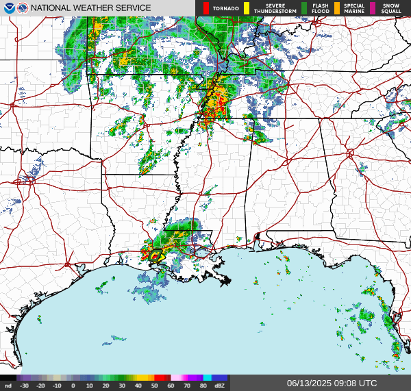
Storms in N TX headed thisaway.
Odd pattern, not moving how I would expect .
Odd pattern, not moving how I would expect .
packyderms_wife
Neither here nor there.
RT 9:04 - Max Velocity
In this weather forecast, we are breaking down a HUGE storm that will bring severe weather and flooding potential to the United States this week. Large hail, damaging winds, and tornadoes will all be possible. Find the latest details of the weather across the United States in our latest weather forecast.
FYI
April 8-12, 2024 - Wisconsin Tornado and Severe Weather Awareness Week
April 8-12, 2024 - Wisconsin Tornado and Severe Weather Awareness Week
packyderms_wife
Neither here nor there.
Haven't seen anything from Ryan Hall, Y'all yet but Max Velocity is currently covering the storms in Texas.
I think Ryan has some family stuff going on right now... Max does a very good job as does Andy, and NW116, and Ryan recommends all three. Max is finishing his Masters degree in Meteorology down in TX at one of the univ with the infamous meteorology program.
SouthernBreeze
Has No Life - Lives on TB
Flood watches up for our area of NE MS through Thursday. It's been raining almost nonstop, since Sunday night.
SusieSunshine
Veteran Member
Tornado Watch
THE NATIONAL WEATHER SERVICE HAS ISSUED TORNADO WATCH 94 IN EFFECT UNTIL 5 PM CDT THIS AFTERNOON FOR THE FOLLOWING AREAS IN TEXAS THIS WATCH INCLUDES 10 COUNTIES IN SOUTH CENTRAL TEXAS BASTROP BLANCO BURNET CALDWELL COMAL GUADALUPE HAYS LEE TRAVIS WILLIAMSON THIS INCLUDES THE CITIES OF AUSTIN, BASTROP, BLANCO, BURNET, GEORGETOWN, GIDDINGS, LOCKHART, NEW BRAUNFELS, SAN MARCOS, AND SEGUIN.
THE NATIONAL WEATHER SERVICE HAS ISSUED TORNADO WATCH 94 IN EFFECT UNTIL 5 PM CDT THIS AFTERNOON FOR THE FOLLOWING AREAS IN TEXAS THIS WATCH INCLUDES 10 COUNTIES IN SOUTH CENTRAL TEXAS BASTROP BLANCO BURNET CALDWELL COMAL GUADALUPE HAYS LEE TRAVIS WILLIAMSON THIS INCLUDES THE CITIES OF AUSTIN, BASTROP, BLANCO, BURNET, GEORGETOWN, GIDDINGS, LOCKHART, NEW BRAUNFELS, SAN MARCOS, AND SEGUIN.
packyderms_wife
Neither here nor there.
LIVE STREAM - Ryan Hall y'all
LIVE - Severe Weather Outbreak With Storm Chasers On The Ground - Live Weather Channel...
Walbash
Contributing Member
LIVE - Severe Weather Outbreak With Storm Chasers On The Ground - Live Weather Channel...
Ryan Hall is live again today Public Severe Weather Outlook (PWO)

PUBLIC SEVERE WEATHER OUTLOOK
NWS STORM PREDICTION CENTER NORMAN OK
0356 AM CDT WED APR 10 2024
...Severe thunderstorms expected over parts of the Central Gulf
Coast States today...
* LOCATIONS...
Southern Mississippi
Eastern and Southeastern Louisiana
Southern Alabama
Florida Panhandle
* HAZARDS...
Widespread damaging winds, some hurricane force
Several tornadoes, a few intense
Isolated large hail
* SUMMARY...
Widespread severe thunderstorms are forecast across parts of the
central Gulf Coast States. The potential will exist for several
tornadoes, a few of which may be strong (EF2+), and widespread
damaging winds, some of which may exceed 75 mph.
Preparedness actions...
Review your severe weather safety procedures for the possibility
of dangerous weather today. Stay tuned to NOAA Weather Radio,
weather.gov, or other media for watches and warnings. A watch
means that conditions are favorable for severe thunderstorms
over the next several hours. If a severe thunderstorm warning is
issued for your area, move to a place of safety, ideally in an
interior room on the lowest floor of a sturdy building.
&&
..Mosier.. 04/10/2024
Storm Prediction Center Public Severe Weather Outlook (PWO)
Severe weather, tornado, thunderstorm, fire weather, storm report, tornado watch, severe thunderstorm watch, mesoscale discussion, convective outlook products from the Storm Prediction Center.
www.spc.noaa.gov
packyderms_wife
Neither here nor there.
Severe Weather Statement
National Weather Service New Orleans LA
Issued by National Weather Service Mobile AL
1119 AM CDT Wed Apr 10 2024
MSC059-101645-
/O.CON.KLIX.TO.W.0013.000000T0000Z-240410T1645Z/
Jackson MS-
1119 AM CDT Wed Apr 10 2024
...A TORNADO WARNING REMAINS IN EFFECT UNTIL 1145 AM CDT FOR
NORTHWESTERN JACKSON COUNTY...
At 1119 AM CDT, a severe thunderstorm capable of producing a tornado
was located 8 miles northwest of Vancleave, or 13 miles north of St.
Martin, moving northeast at 35 mph.
HAZARD...Tornado.
SOURCE...Radar indicated rotation.
IMPACT...Flying debris will be dangerous to those caught without
shelter. Mobile homes will be damaged or destroyed. Damage
to roofs, windows, and vehicles will occur. Tree damage is
likely.
This tornadic thunderstorm will remain over mainly rural areas of
northwestern Jackson County.
PRECAUTIONARY/PREPAREDNESS ACTIONS...
TAKE COVER NOW! Move to a basement or an interior room on the lowest
floor of a sturdy building. Avoid windows. If you are outdoors, in a
mobile home, or in a vehicle, move to the closest substantial shelter
and protect yourself from flying debris.
&&
LAT...LON 3054 8877 3064 8888 3066 8888 3073 8878
3074 8870 3074 8864 3073 8860 3072 8857
3064 8855 3064 8856
TIME...MOT...LOC 1619Z 228DEG 30KT 3062 8878
TORNADO...RADAR INDICATED
MAX HAIL SIZE...<.75 IN
$$
Black
packyderms_wife
Neither here nor there.
This is a rarely seen NWS warning product.
-----------------
BULLETIN - EAS ACTIVATION REQUESTED
Flash Flood Warning
National Weather Service New Orleans LA
1213 PM CDT Wed Apr 10 2024
...FLASH FLOOD EMERGENCY FOR CITY OF NEW ORLEANS...
The National Weather Service in New Orleans has extended the
* Flash Flood Warning for...
Southern Tangipahoa Parish in southeastern Louisiana...
* Until 215 PM CDT.
* At 1213 PM CDT, Doppler radar indicated thunderstorms producing
heavy rain across the warned area. Between 4.5 and 7.5 inches of
rain have fallen. Additional rainfall amounts of 1 to 3 inches are
possible in the warned area. Flash flooding is ongoing or expected
to begin shortly.
This is a FLASH FLOOD EMERGENCY for City of New Orleans. This is a
PARTICULARLY DANGEROUS SITUATION. SEEK HIGHER GROUND NOW!
HAZARD...Life threatening flash flooding. Thunderstorms
producing flash flooding.
SOURCE...Radar.
IMPACT...This is a PARTICULARLY DANGEROUS SITUATION. SEEK
HIGHER GROUND NOW! Life threatening flash flooding of
low water crossings, small creeks and streams, urban
areas, highways, streets and underpasses.
* Some locations that will experience flash flooding include...
Hammond, Ponchatoula, Springfield, Natalbany, Robert and Tickfaw.
This includes the following Interstates...
Interstate 55 in Louisiana between mile markers 24 and 38.
Interstate 12 between mile markers 35 and 47.
PRECAUTIONARY/PREPAREDNESS ACTIONS...
Move to higher ground now! This is an extremely dangerous and
life-threatening situation. Do not attempt to travel unless you are
fleeing an area subject to flooding or under an evacuation order.
Turn around, don`t drown when encountering flooded roads. Most flood
deaths occur in vehicles.
Be aware of your surroundings and do not drive on flooded roads.
&&
LAT...LON 3044 9055 3047 9055 3049 9057 3060 9057
3060 9040 3052 9031 3041 9036 3041 9051
3042 9054
FLASH FLOOD...RADAR INDICATED
FLASH FLOOD DAMAGE THREAT...CATASTROPHIC
$$
CAB
packyderms_wife
Neither here nor there.
Ryan's streaming about the flash flooding right now, had a sheriff on about half hour ago, asking people to please stay home. Lots of water rescues going on this afternoon.

packyderms_wife
Neither here nor there.
Not good at all!
 www.timebomb2000.com
ALERT - Yazoo County, Mississippi Sheriff Warns Residents That Levees Are About to Break: "Evacuate IMMEDIATELY!"
https://www.thegatewaypundit.com/2024/04/developing-yazoo-county-mississippi-sheriff-warns-residents-that/ DEVELOPING: Yazoo County, Mississippi Sheriff Warns Residents That Levees Are About to Break: "Evacuate IMMEDIATELY!" Strong storms moved into Mississippi on Tuesday evening...
SEVERE WEATHER STATEMENT
NATIONAL WEATHER SERVICE JACKSONVILLE FL
1154 AM EDT THU APR 11 2024
FLC109-111600-
/O.CON.KJAX.TO.W.0039.000000T0000Z-240411T1600Z/
ST. JOHNS FL-
1154 AM EDT THU APR 11 2024
...A TORNADO WARNING REMAINS IN EFFECT UNTIL NOON EDT FOR EAST
CENTRAL ST. JOHNS COUNTY...
AT 1154 AM EDT, A CONFIRMED LARGE AND EXTREMELY DANGEROUS TORNADO WAS
LOCATED NEAR SOUTH PONTE VEDRA, OR 8 MILES NORTHWEST OF SAINT
AUGUSTINE, MOVING EAST AT 45 MPH.
THIS IS A PARTICULARLY DANGEROUS SITUATION. TAKE COVER NOW!
HAZARD...DAMAGING TORNADO.
SOURCE...LAW ENFORCEMENT CONFIRMED TORNADO.
IMPACT...YOU ARE IN A LIFE-THREATENING SITUATION. FLYING DEBRIS MAY
BE DEADLY TO THOSE CAUGHT WITHOUT SHELTER. MOBILE HOMES
WILL BE DESTROYED. CONSIDERABLE DAMAGE TO HOMES,
BUSINESSES, AND VEHICLES IS LIKELY AND COMPLETE DESTRUCTION
IS POSSIBLE.
THE TORNADO WILL BE NEAR...
SOUTH PONTE VEDRA AND VILANO BEACH AROUND 1200 PM EDT.
OTHER LOCATIONS IMPACTED BY THIS TORNADIC THUNDERSTORM INCLUDE
ANASTASIA AND SOUTH PONTE VEDRA BEACH.
PRECAUTIONARY/PREPAREDNESS ACTIONS...
TO REPEAT, A LARGE, EXTREMELY DANGEROUS AND POTENTIALLY DEADLY
TORNADO IS ON THE GROUND. TO PROTECT YOUR LIFE, TAKE COVER NOW! MOVE
TO A BASEMENT OR AN INTERIOR ROOM ON THE LOWEST FLOOR OF A STURDY
BUILDING. AVOID WINDOWS. IF YOU ARE OUTDOORS, IN A MOBILE HOME, OR IN
A VEHICLE, MOVE TO THE CLOSEST SUBSTANTIAL SHELTER AND PROTECT
YOURSELF FROM FLYING DEBRIS.
MOTORISTS SHOULD NOT TAKE SHELTER UNDER HIGHWAY OVERPASSES. IF YOU
CANNOT SAFELY DRIVE AWAY FROM THE TORNADO, AS A LAST RESORT, EITHER
PARK YOUR VEHICLE AND STAY PUT, OR ABANDON YOUR VEHICLE AND LIE DOWN
IN A LOW LYING AREA AND PROTECT YOURSELF FROM FLYING DEBRIS.
HEAVY RAINFALL MAY HIDE THIS TORNADO. DO NOT WAIT TO SEE OR HEAR THE
TORNADO. TAKE COVER NOW!
packyderms_wife
Neither here nor there.
packyderms_wife
Neither here nor there.
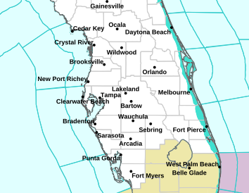
Florida

packyderms_wife
Neither here nor there.
Tornado Warning
FLC101-111630-
/O.NEW.KTBW.TO.W.0007.240411T1607Z-240411T1630Z/
BULLETIN - EAS ACTIVATION REQUESTED
Tornado Warning
National Weather Service Tampa Bay Area Ruskin FL
1207 PM EDT Thu Apr 11 2024
The National Weather Service in Ruskin has issued a
* Tornado Warning for...
Northwestern Pasco County in west central Florida...
* Until 1230 PM EDT.
* At 1207 PM EDT, a severe thunderstorm capable of producing a
tornado was located near New Port Richey, moving northeast at 40
mph.
HAZARD...Tornado.
SOURCE...Radar indicated rotation.
IMPACT...Flying debris will be dangerous to those caught without
shelter. Mobile homes will be damaged or destroyed.
Damage to roofs, windows, and vehicles will occur. Tree
damage is likely.
* This dangerous storm will be near...
New Port Richey, Hudson, Jasmine Estates, and New Port Richey East
around 1215 PM EDT.
Other locations impacted by this tornadic thunderstorm include Moon
Lake, Gowers Corner, Bayonet Point, and Shady Hills.
PRECAUTIONARY/PREPAREDNESS ACTIONS...
TAKE COVER NOW! If your home is flooded, avoid flood waters. If
possible, take shelter in an interior room. Avoid windows. If you are
outdoors, in a mobile home, or in a vehicle, move to the closest
substantial shelter and protect yourself from flying debris.
&&
LAT...LON 2843 8258 2843 8257 2829 8246 2822 8278
2828 8283
TIME...MOT...LOC 1607Z 242DEG 35KT 2826 8277
TORNADO...RADAR INDICATED
MAX HAIL SIZE...<.75 IN
$$
TBW
packyderms_wife
Neither here nor there.
Tornado Warning
FLC103-111645-
/O.NEW.KTBW.TO.W.0008.240411T1616Z-240411T1645Z/
BULLETIN - EAS ACTIVATION REQUESTED
Tornado Warning
National Weather Service Tampa Bay Area Ruskin FL
1216 PM EDT Thu Apr 11 2024
The National Weather Service in Ruskin has issued a
* Tornado Warning for...
Northwestern Pinellas County in west central Florida...
* Until 1245 PM EDT.
* At 1215 PM EDT, a severe thunderstorm capable of producing a
tornado was located near Harbor Bluffs, or 7 miles northwest of
Seminole, moving northeast at 35 mph.
HAZARD...Tornado.
SOURCE...Radar indicated rotation.
IMPACT...Flying debris will be dangerous to those caught without
shelter. Mobile homes will be damaged or destroyed.
Damage to roofs, windows, and vehicles will occur. Tree
damage is likely.
* This dangerous storm will be near...
Clearwater, Largo, Harbor Bluffs, and Ridgecrest around 1220 PM
EDT.
Palm Harbor around 1225 PM EDT.
East Lake around 1230 PM EDT.
Other locations impacted by this tornadic thunderstorm include
Belleair Bluffs, Indian Shores, Walsingham Park, Belleair Shore,
Crystal Beach, Belleair, Belleair Shores, Belleair Beach, Oldsmar,
and Safety Harbor.
PRECAUTIONARY/PREPAREDNESS ACTIONS...
TAKE COVER NOW! If your home is flooded, avoid flood waters. If
possible, take shelter in an interior room. Avoid windows. If you are
outdoors, in a mobile home, or in a vehicle, move to the closest
substantial shelter and protect yourself from flying debris.
&&
LAT...LON 2796 8291 2813 8275 2804 8265 2802 8265
2803 8264 2801 8264 2801 8262 2781 8289
2786 8291
TIME...MOT...LOC 1615Z 223DEG 32KT 2788 8290
TORNADO...RADAR INDICATED
MAX HAIL SIZE...0.00 IN
$$
TBW
packyderms_wife
Neither here nor there.
This weeks thread is posted, looks like things are gonna get spicy tonight into Tuesday
- Status
- Not open for further replies.