
You are using an out of date browser. It may not display this or other websites correctly.
You should upgrade or use an alternative browser.
You should upgrade or use an alternative browser.
WEATHER Severe Weather for the Week of February 5th, 2024
- Thread starter packyderms_wife
- Start date

packyderms_wife
Neither here nor there.
Current Map | U.S. Drought Monitor
 droughtmonitor.unl.edu
interactive drought monitor map that changes daily, not able to post the map here.

SouthernBreeze
Has No Life - Lives on TB
In my area of Mississippi, we've gone from exceptional drought to severe drought. We have been getting some much needed rainfall, lately.
packyderms_wife
Neither here nor there.
Took a screen shot of the current interactive drought monitor map...
Thanks!
packyderms_wife
Neither here nor there.
RT 8:52 - Max Velocity
In this weather forecast, we are breaking down a BIG STORM that will bring isolated severe weather, flooding rains, and slightly cooler weather to the United States! Additionally, a large storm will crash into California tonight, bringing up to 6-10" of rainfall in some spots, with up to 100" of snow possible! These will impact areas like the Southern Plains, Mississippi Valley, Midwest, and Ohio Valley. This weather pattern is a part of El Nino, which has led to more active weather in the Southern Tier of the USA, while the Northern Tier has been less active. This will lead to some snow events, showers and storms, and perhaps severe weather. Find the latest details of the weather across the United States in our latest weather forecast.
pauldingbabe
The Great Cat
Yes! More rain today for Georgia!
I can finally breathe!
")
I can finally breathe!
packyderms_wife
Neither here nor there.
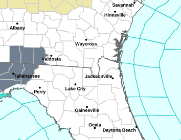
Tornado Warning
FLC023-047-GAC065-101-042030-
/O.NEW.KJAX.TO.W.0017.240204T1956Z-240204T2030Z/
BULLETIN - EAS ACTIVATION REQUESTED
Tornado Warning
National Weather Service Jacksonville FL
256 PM EST Sun Feb 4 2024
The National Weather Service in Jacksonville has issued a
* Tornado Warning for...
North central Columbia County in northern Florida...
Northeastern Hamilton County in northern Florida...
Southeastern Echols County in southeastern Georgia...
Southeastern Clinch County in southeastern Georgia...
* Until 330 PM EST.
* At 255 PM EST, a severe thunderstorm capable of producing a tornado
was located near Needmore, or 9 miles southwest of Fargo, moving
north at 25 mph.
HAZARD...Tornado.
SOURCE...Radar indicated rotation.
IMPACT...Flying debris will be dangerous to those caught without
shelter. Mobile homes will be damaged or destroyed.
Damage to roofs, windows, and vehicles will occur. Tree
damage is likely.
* This dangerous storm will be near...
Needmore around 300 PM EST.
PRECAUTIONARY/PREPAREDNESS ACTIONS...
TAKE COVER NOW! Move to a basement or an interior room on the lowest
floor of a sturdy building. Avoid windows. If you are outdoors, in a
mobile home, or in a vehicle, move to the closest substantial shelter
and protect yourself from flying debris.
&&
LAT...LON 3089 8277 3084 8249 3082 8250 3082 8247
3052 8265 3054 8276
TIME...MOT...LOC 1955Z 190DEG 23KT 3058 8268
TORNADO...RADAR INDICATED
MAX HAIL SIZE...<.75 IN
$$
23
packyderms_wife
Neither here nor there.
Tornado Warning
GAC027-071-275-042030-
/O.NEW.KTAE.TO.W.0033.240204T1951Z-240204T2030Z/
BULLETIN - EAS ACTIVATION REQUESTED
Tornado Warning
National Weather Service Tallahassee FL
251 PM EST Sun Feb 4 2024
The National Weather Service in Tallahassee has issued a
* Tornado Warning for...
Northeastern Thomas County in south central Georgia...
Northwestern Brooks County in south central Georgia...
Southwestern Colquitt County in south central Georgia...
* Until 330 PM EST.
* At 250 PM EST, a severe thunderstorm capable of producing a tornado
was located near Pavo, or 11 miles south of Moultrie, moving north
at 40 mph.
HAZARD...Tornado.
SOURCE...Radar indicated rotation.
IMPACT...Flying debris will be dangerous to those caught without
shelter. Mobile homes will be damaged or destroyed.
Damage to roofs, windows, and vehicles will occur. Tree
damage is likely.
* This dangerous storm will be near...
Moultrie around 255 PM EST.
Riverside around 305 PM EST.
Other locations impacted by this tornadic thunderstorm include
Funston, Moultrie Municipal A/P, Autreyville, Enon, Spence Airport,
Murphy, and South Moultrie.
PRECAUTIONARY/PREPAREDNESS ACTIONS...
TAKE COVER NOW! Move to a basement or an interior room on the lowest
floor of a sturdy building. Avoid windows. If you are outdoors, in a
mobile home, or in a vehicle, move to the closest substantial shelter
and protect yourself from flying debris.
&&
LAT...LON 3097 8368 3095 8382 3122 8392 3125 8370
TIME...MOT...LOC 1950Z 166DEG 33KT 3101 8374
TORNADO...RADAR INDICATED
MAX HAIL SIZE...<.75 IN
$$
16-WORSTER
packyderms_wife
Neither here nor there.
Georgia and Florida

packyderms_wife
Neither here nor there.
LIVE STREAM - Max Velocity
BREAKING - Multiple Tornado Warnings In Florida & Georgia - Severe Weather Live Coverage
packyderms_wife
Neither here nor there.
Tornado Warning
FLC007-019-031-042200-
/O.NEW.KJAX.TO.W.0021.240204T2113Z-240204T2200Z/
BULLETIN - EAS ACTIVATION REQUESTED
Tornado Warning
National Weather Service Jacksonville FL
413 PM EST Sun Feb 4 2024
The National Weather Service in Jacksonville has issued a
* Tornado Warning for...
Northeastern Bradford County in northern Florida...
Northwestern Clay County in northeastern Florida...
Southwestern Duval County in northeastern Florida...
* Until 500 PM EST.
* At 412 PM EST, a severe thunderstorm capable of producing a tornado
was located near Camp Blanding, or near Middleburg, moving
northeast at 20 mph.
HAZARD...Tornado.
SOURCE...Radar indicated rotation.
IMPACT...Flying debris will be dangerous to those caught without
shelter. Mobile homes will be damaged or destroyed.
Damage to roofs, windows, and vehicles will occur. Tree
damage is likely.
* This dangerous storm will be near...
Middleburg around 420 PM EST.
Other locations impacted by this tornadic thunderstorm include
Lawtey.
PRECAUTIONARY/PREPAREDNESS ACTIONS...
TAKE COVER NOW! Move to a basement or an interior room on the lowest
floor of a sturdy building. Avoid windows. If you are outdoors, in a
mobile home, or in a vehicle, move to the closest substantial shelter
and protect yourself from flying debris.
&&
LAT...LON 2997 8200 3002 8208 3022 8199 3012 8179
TIME...MOT...LOC 2112Z 208DEG 19KT 3002 8201
TORNADO...RADAR INDICATED
MAX HAIL SIZE...<.75 IN
$$
23
packyderms_wife
Neither here nor there.
Tornado Warning
FLC019-031-042145-
/O.NEW.KJAX.TO.W.0020.240204T2112Z-240204T2145Z/
BULLETIN - EAS ACTIVATION REQUESTED
Tornado Warning
National Weather Service Jacksonville FL
412 PM EST Sun Feb 4 2024
The National Weather Service in Jacksonville has issued a
* Tornado Warning for...
North central Clay County in northeastern Florida...
Southwestern Duval County in northeastern Florida...
* Until 445 PM EST.
* At 411 PM EST, a severe thunderstorm capable of producing a tornado
was located over Cecil Field, or 11 miles north of Middleburg,
moving northeast at 25 mph.
HAZARD...Tornado.
SOURCE...Radar indicated rotation.
IMPACT...Flying debris will be dangerous to those caught without
shelter. Mobile homes will be damaged or destroyed.
Damage to roofs, windows, and vehicles will occur. Tree
damage is likely.
* This dangerous storm will be near...
Jacksonville and Cecil Field around 415 PM EST.
Normandy around 430 PM EST.
Cisco Gardens around 435 PM EST.
Other locations impacted by this tornadic thunderstorm include
Jacksonville Heights and Whitehouse Air Field.
PRECAUTIONARY/PREPAREDNESS ACTIONS...
TAKE COVER NOW! Move to a basement or an interior room on the lowest
floor of a sturdy building. Avoid windows. If you are outdoors, in a
mobile home, or in a vehicle, move to the closest substantial shelter
and protect yourself from flying debris.
&&
LAT...LON 3037 8164 3015 8189 3019 8197 3042 8189
3044 8187
TIME...MOT...LOC 2111Z 208DEG 20KT 3022 8189
TORNADO...RADAR INDICATED
MAX HAIL SIZE...<.75 IN
$$
23
packyderms_wife
Neither here nor there.
the weather is definitely spicy in the south east this evening.
jward
passin' thru
y'all catch this one? 
R A W S A L E R T S
@rawsalerts
#WATCH: Incredible Footage Captures Power Tornado Spawning Across Over people backyard and houses
#Valdosta | #Georgia
Watch incredible footage captured in Valdosta, Georgia, as witnesses watch in awe while a tornado spawns and moves across people's backyards and over houses this took place around 3;06 eastern standard time. Multiple tornado warnings have been issued across the Georgia and Florida area due to rotating thunderstorms with some of them producing tornados. At this time No injuries have been reported, but there are reports of damage.
View: https://twitter.com/rawsalerts/status/1754255551968505895?s=20


packyderms_wife
Neither here nor there.
We have had a pretty mild winter in SE MI. Close to 40-50 all but a couple days last week, and this week ahead.
Same here in Iowa. Lots of dense fog.
packyderms_wife
Neither here nor there.
RT 9:18 - Reed Timmer
CAT 5 Atmospheric River Event in Southern California
Powerful atmospheric river event is hammering Southern California from Santa Barbara through Los Angeles, with short range models now showing over a foot of rainfall above LA. This will cause dangerous and life threatening flash flooding. This video shows the very beginning of this historic weather event.
packyderms_wife
Neither here nor there.
RT 8:05 - Ryan Hall y'all Xtra
In this video we are talking about the California storm and how it will impact the rest of the US.
packyderms_wife
Neither here nor there.
RT 4:06 - FOX Weather
Atmospheric River Storm: Landslides Send Large Boulders, Debris Down Steep Landscape In Los Angeles
FOX Weather Correspondent Max Gorden is in Los Angeles where landslides have sent large boulders and debris rushing down the steep landscape of the Hollywood Hills as a deadly atmospheric river continues to slam Southern California with torrential rain and damaging wind gusts
packyderms_wife
Neither here nor there.
Clouds have moved in, hoping for some rain. central Iowa.
packyderms_wife
Neither here nor there.
RT 10:03 - Max Velocity
A Bunch Of SNOW Is Coming...
In this weather forecast, we are breaking down a NEW STORM that will bring the potential for a winter storm this weekend! This could dump several inches of snow from Texas and Oklahoma, back through New England! Additionally, another storm will pose a threat of a few severe thunderstorms in the Midwest today. These will impact areas like the Southern Plains, Mississippi Valley, Midwest, and Ohio Valley. This weather pattern is a part of El Nino, which has led to more active weather in the Southern Tier of the USA, while the Northern Tier has been less active. This will lead to some snow events, showers and storms, and perhaps severe weather. Find the latest details of the weather across the United States in our latest weather forecast.packyderms_wife
Neither here nor there.
RT 8:08 - Ryan Hall y'all xtra
These Storms Will Bring Tornadoes AND Snow…
In this video we are talking about a series of storms that will cause lots of problems in the USA.
Mesoscale Discussion 0113
NWS Storm Prediction Center Norman OK
0253 PM CST Thu Feb 08 2024
Areas affected...Parts of northern IL into extreme eastern
IA/southern WI
Concerning...Severe potential...Watch unlikely
Valid 082053Z - 082330Z
Probability of Watch Issuance...20 percent
SUMMARY...A supercell or two may develop later this afternoon. Large
hail, gusty winds, and possibly a tornado will all be possible,
though coverage of the threat is expected to remain isolated.
DISCUSSION...Convection is gradually deepening within a cumulus
field this afternoon from eastern IA/northeast MO into western IL,
in advance of a mid/upper-level trough approaching the upper MS
Valley. Low-level moisture remains rather modest across the region,
with surface dewpoints generally in the mid/upper 40s F. However,
seasonably strong diurnal heating beneath cold temperatures aloft is
supporting MLCAPE of around 500 J/kg, along with diminishing MLCINH.
Destabilization should spread into a larger portion of northern IL
and southern WI through late afternoon, in conjunction with eastward
progression of the midlevel cold pool.
The primary midlevel vorticity maximum and attendant surface cyclone
are moving northeastward across MN, and large-scale ascent may
remain rather modest across the effective warm sector. However, a
low-amplitude shortwave is moving through the base of the
mid/upper-level trough near the IA/MO border, and may aid in
thunderstorm development as any remaining convective inhibition is
removed.
Strong deep-layer shear across the region will conditionally support
organized convection, and a supercell or two may eventually evolve
out of initial storm development. Steep tropospheric lapse rates
will support large hail and locally gusty winds with the strongest
storms. Also, despite less than ideal low-level moisture, a tornado
cannot be ruled out given the presence of favorable low-level shear
and lapse rates. At this time, coverage of the severe threat is
expected to remain rather isolated.
..Dean/Goss.. 02/08/2024
packyderms_wife
Neither here nor there.
BREAKING - Tornado On The Ground In Illinois - Severe Weather Coverage With Live Storm Chaser
LIVE STREAM - Max Velocity
packyderms_wife
Neither here nor there.
CONFIRMED TORNADO on the ground near Henry, Illinois it's both visual and radar confirmed.
packyderms_wife
Neither here nor there.

Iowa/Illinois radar.
packyderms_wife
Neither here nor there.
Now upgraded to a Tornado Warning!!!
Severe Weather Statement
National Weather Service Quad Cities IA/IL
436 PM CST Thu Feb 8 2024
ILC011-155-082315-
/O.CON.KDVN.SV.W.0002.000000T0000Z-240208T2315Z/
Putnam IL-Bureau IL-
436 PM CST Thu Feb 8 2024
...A SEVERE THUNDERSTORM WARNING REMAINS IN EFFECT UNTIL 515 PM CST
FOR PUTNAM AND SOUTHEASTERN BUREAU COUNTIES...
At 436 PM CST, a severe thunderstorm was located over Henry, or 7
miles north of Lacon, moving northeast at 50 mph.
HAZARD...60 mph wind gusts and quarter size hail.
SOURCE...Radar indicated.
IMPACT...Hail damage to vehicles is expected. Expect wind damage to
roofs, siding, and trees.
Locations impacted include...
Hennepin, Spring Valley, Henry, DePue, Granville, Ladd, Dalzell,
McNabb, Putnam, Mark, Magnolia, Standard, and Florid.
This includes the following highways...
Interstate 80 in Illinois between mile markers 70 and 73.
Interstate 180 near mile marker 1.
PRECAUTIONARY/PREPAREDNESS ACTIONS...
For your protection move to an interior room on the lowest floor of a
sturdy building.
To report severe weather contact your nearest law enforcement agency.
They will send your report to the National Weather Service office in
the Quad Cities.
&&
LAT...LON 4110 8936 4112 8934 4115 8933 4115 8950
4142 8916 4111 8916
TIME...MOT...LOC 2236Z 234DEG 42KT 4113 8935
HAIL THREAT...RADAR INDICATED
MAX HAIL SIZE...1.00 IN
WIND THREAT...RADAR INDICATED
MAX WIND GUST...60 MPH
$$
McClure
GOES-East high resolution visible satellite,

packyderms_wife
Neither here nor there.
Illinois!!!
Tornado Warning
ILC155-082315-
/O.NEW.KDVN.TO.W.0001.240208T2241Z-240208T2315Z/
BULLETIN - EAS ACTIVATION REQUESTED
Tornado Warning
National Weather Service Quad Cities IA/IL
441 PM CST Thu Feb 8 2024
The National Weather Service in the Quad Cities has issued a
* Tornado Warning for...
Putnam County in north central Illinois...
* Until 515 PM CST.
* At 441 PM CST, a severe thunderstorm capable of producing a tornado
was located over Lake Wildwood, or 8 miles northeast of Lacon,
moving northeast at 45 mph.
HAZARD...Tornado and quarter size hail.
SOURCE...Radar indicated rotation.
IMPACT...Flying debris will be dangerous to those caught without
shelter. Mobile homes will be damaged or destroyed.
Damage to roofs, windows, and vehicles will occur. Tree
damage is likely.
* This dangerous storm will be near...
Granville, McNabb, Mark, Magnolia, Standard, and Florid around 445
PM CST.
PRECAUTIONARY/PREPAREDNESS ACTIONS...
TAKE COVER NOW! Move to a basement or an interior room on the lowest
floor of a sturdy building. Avoid windows. If you are outdoors, in a
mobile home, or in a vehicle, move to the closest substantial shelter
and protect yourself from flying debris.
&&
LAT...LON 4110 8936 4112 8934 4115 8933 4115 8944
4131 8918 4131 8916 4110 8916
TIME...MOT...LOC 2241Z 234DEG 41KT 4111 8930
TORNADO...RADAR INDICATED
MAX HAIL SIZE...1.00 IN
$$
McClure
Tornado Warning
ILC155-082315-
/O.NEW.KDVN.TO.W.0001.240208T2241Z-240208T2315Z/
BULLETIN - EAS ACTIVATION REQUESTED
Tornado Warning
National Weather Service Quad Cities IA/IL
441 PM CST Thu Feb 8 2024
The National Weather Service in the Quad Cities has issued a
* Tornado Warning for...
Putnam County in north central Illinois...
* Until 515 PM CST.
* At 441 PM CST, a severe thunderstorm capable of producing a tornado
was located over Lake Wildwood, or 8 miles northeast of Lacon,
moving northeast at 45 mph.
HAZARD...Tornado and quarter size hail.
SOURCE...Radar indicated rotation.
IMPACT...Flying debris will be dangerous to those caught without
shelter. Mobile homes will be damaged or destroyed.
Damage to roofs, windows, and vehicles will occur. Tree
damage is likely.
* This dangerous storm will be near...
Granville, McNabb, Mark, Magnolia, Standard, and Florid around 445
PM CST.
PRECAUTIONARY/PREPAREDNESS ACTIONS...
TAKE COVER NOW! Move to a basement or an interior room on the lowest
floor of a sturdy building. Avoid windows. If you are outdoors, in a
mobile home, or in a vehicle, move to the closest substantial shelter
and protect yourself from flying debris.
&&
LAT...LON 4110 8936 4112 8934 4115 8933 4115 8944
4131 8918 4131 8916 4110 8916
TIME...MOT...LOC 2241Z 234DEG 41KT 4111 8930
TORNADO...RADAR INDICATED
MAX HAIL SIZE...1.00 IN
$$
McClure
packyderms_wife
Neither here nor there.
I love Max's commentary... there is literally snow on the ground and we're chasing tornadoes! 
packyderms_wife
Neither here nor there.
Severe Weather Statement
National Weather Service Quad Cities IA/IL
448 PM CST Thu Feb 8 2024
ILC155-082315-
/O.CON.KDVN.TO.W.0001.000000T0000Z-240208T2315Z/
Putnam IL-
448 PM CST Thu Feb 8 2024
...A TORNADO WARNING REMAINS IN EFFECT UNTIL 515 PM CST FOR
SOUTHEASTERN PUTNAM COUNTY...
At 448 PM CST, a severe thunderstorm capable of producing a tornado
was located over McNabb, or 9 miles southeast of Hennepin, moving
northeast at 45 mph.
HAZARD...Tornado and quarter size hail.
SOURCE...Radar indicated rotation.
IMPACT...Flying debris will be dangerous to those caught without
shelter. Mobile homes will be damaged or destroyed. Damage
to roofs, windows, and vehicles will occur. Tree damage is
likely.
This dangerous storm will be near...
Standard around 455 PM CST.
PRECAUTIONARY/PREPAREDNESS ACTIONS...
TAKE COVER NOW! Move to a basement or an interior room on the lowest
floor of a sturdy building. Avoid windows. If you are outdoors, in a
mobile home, or in a vehicle, move to the closest substantial shelter
and protect yourself from flying debris.
This storm has a history of producing tornadoes. Seek shelter now!
&&
LAT...LON 4110 8936 4112 8934 4115 8933 4118 8929
4125 8919 4127 8916 4110 8916
TIME...MOT...LOC 2248Z 234DEG 41KT 4115 8922
TORNADO...RADAR INDICATED
MAX HAIL SIZE...1.00 IN
$$
McClure
packyderms_wife
Neither here nor there.
Wisconsin!
Tornado Warning
WIC045-082330-
/O.NEW.KMKX.TO.W.0001.240208T2304Z-240208T2330Z/
BULLETIN - EAS ACTIVATION REQUESTED
Tornado Warning
National Weather Service Milwaukee/Sullivan WI
504 PM CST Thu Feb 8 2024
The National Weather Service in Milwaukee/Sullivan has issued a
* Tornado Warning for...
Southeastern Green County in south central Wisconsin...
* Until 530 PM CST.
* At 504 PM CST, a severe thunderstorm capable of producing a tornado
was located near Monroe, moving northeast at 40 mph.
HAZARD...Tornado and quarter size hail.
SOURCE...Radar indicated rotation.
IMPACT...Flying debris will be dangerous to those caught without
shelter. Mobile homes will be damaged or destroyed.
Damage to roofs, windows, and vehicles will occur. Tree
damage is likely.
* Locations impacted include...
Monroe, Brodhead, Monticello, Albany, Juda, and Attica.
PRECAUTIONARY/PREPAREDNESS ACTIONS...
TAKE COVER NOW! Move to a basement or an interior room on the lowest
floor of a sturdy building. Avoid windows. If you are outdoors, in a
mobile home, or in a vehicle, move to the closest substantial shelter
and protect yourself from flying debris.
&&
LAT...LON 4250 8973 4255 8977 4266 8971 4280 8953
4272 8937 4258 8936 4250 8953
TIME...MOT...LOC 2304Z 222DEG 35KT 4256 8969
TORNADO...RADAR INDICATED
MAX HAIL SIZE...1.00 IN
$$
WAGNER
Tornado Warning
WIC045-082330-
/O.NEW.KMKX.TO.W.0001.240208T2304Z-240208T2330Z/
BULLETIN - EAS ACTIVATION REQUESTED
Tornado Warning
National Weather Service Milwaukee/Sullivan WI
504 PM CST Thu Feb 8 2024
The National Weather Service in Milwaukee/Sullivan has issued a
* Tornado Warning for...
Southeastern Green County in south central Wisconsin...
* Until 530 PM CST.
* At 504 PM CST, a severe thunderstorm capable of producing a tornado
was located near Monroe, moving northeast at 40 mph.
HAZARD...Tornado and quarter size hail.
SOURCE...Radar indicated rotation.
IMPACT...Flying debris will be dangerous to those caught without
shelter. Mobile homes will be damaged or destroyed.
Damage to roofs, windows, and vehicles will occur. Tree
damage is likely.
* Locations impacted include...
Monroe, Brodhead, Monticello, Albany, Juda, and Attica.
PRECAUTIONARY/PREPAREDNESS ACTIONS...
TAKE COVER NOW! Move to a basement or an interior room on the lowest
floor of a sturdy building. Avoid windows. If you are outdoors, in a
mobile home, or in a vehicle, move to the closest substantial shelter
and protect yourself from flying debris.
&&
LAT...LON 4250 8973 4255 8977 4266 8971 4280 8953
4272 8937 4258 8936 4250 8953
TIME...MOT...LOC 2304Z 222DEG 35KT 4256 8969
TORNADO...RADAR INDICATED
MAX HAIL SIZE...1.00 IN
$$
WAGNER
packyderms_wife
Neither here nor there.

Illinois/Wisconsin
packyderms_wife
Neither here nor there.
Wisconsin
Tornado Warning
WIC045-065-082330-
/O.NEW.KMKX.TO.W.0002.240208T2307Z-240208T2330Z/
BULLETIN - EAS ACTIVATION REQUESTED
Tornado Warning
National Weather Service Milwaukee/Sullivan WI
507 PM CST Thu Feb 8 2024
The National Weather Service in Milwaukee/Sullivan has issued a
* Tornado Warning for...
East central Lafayette County in south central Wisconsin...
Western Green County in south central Wisconsin...
* Until 530 PM CST.
* At 507 PM CST, a severe thunderstorm capable of producing a tornado
was located near Winslow, or 10 miles west of Monroe, moving
northeast at 40 mph.
HAZARD...Tornado and quarter size hail.
SOURCE...Radar indicated rotation.
IMPACT...Flying debris will be dangerous to those caught without
shelter. Mobile homes will be damaged or destroyed.
Damage to roofs, windows, and vehicles will occur. Tree
damage is likely.
* Locations impacted include...
New Glarus, Monticello, Argyle, South Wayne, Browntown, Woodford,
and Jordan Center.
PRECAUTIONARY/PREPAREDNESS ACTIONS...
TAKE COVER NOW! Move to a basement or an interior room on the lowest
floor of a sturdy building. Avoid windows. If you are outdoors, in a
mobile home, or in a vehicle, move to the closest substantial shelter
and protect yourself from flying debris.
&&
LAT...LON 4261 8995 4276 8983 4283 8968 4274 8949
4255 8977 4253 8988
TIME...MOT...LOC 2307Z 228DEG 37KT 4258 8985
TORNADO...RADAR INDICATED
MAX HAIL SIZE...1.00 IN
$$
Tornado Warning
WIC045-065-082330-
/O.NEW.KMKX.TO.W.0002.240208T2307Z-240208T2330Z/
BULLETIN - EAS ACTIVATION REQUESTED
Tornado Warning
National Weather Service Milwaukee/Sullivan WI
507 PM CST Thu Feb 8 2024
The National Weather Service in Milwaukee/Sullivan has issued a
* Tornado Warning for...
East central Lafayette County in south central Wisconsin...
Western Green County in south central Wisconsin...
* Until 530 PM CST.
* At 507 PM CST, a severe thunderstorm capable of producing a tornado
was located near Winslow, or 10 miles west of Monroe, moving
northeast at 40 mph.
HAZARD...Tornado and quarter size hail.
SOURCE...Radar indicated rotation.
IMPACT...Flying debris will be dangerous to those caught without
shelter. Mobile homes will be damaged or destroyed.
Damage to roofs, windows, and vehicles will occur. Tree
damage is likely.
* Locations impacted include...
New Glarus, Monticello, Argyle, South Wayne, Browntown, Woodford,
and Jordan Center.
PRECAUTIONARY/PREPAREDNESS ACTIONS...
TAKE COVER NOW! Move to a basement or an interior room on the lowest
floor of a sturdy building. Avoid windows. If you are outdoors, in a
mobile home, or in a vehicle, move to the closest substantial shelter
and protect yourself from flying debris.
&&
LAT...LON 4261 8995 4276 8983 4283 8968 4274 8949
4255 8977 4253 8988
TIME...MOT...LOC 2307Z 228DEG 37KT 4258 8985
TORNADO...RADAR INDICATED
MAX HAIL SIZE...1.00 IN
$$
packyderms_wife
Neither here nor there.
There appears to be a tornado on the ground south of Madison, WI.
I need to go start in on dinner, making chicken pot pie using the remains of a rotisserie chicken, this should be lot of fun.
I need to go start in on dinner, making chicken pot pie using the remains of a rotisserie chicken, this should be lot of fun.