
You are using an out of date browser. It may not display this or other websites correctly.
You should upgrade or use an alternative browser.
You should upgrade or use an alternative browser.
WEATHER Severe Weather the Week of January 22nd, 2024
- Thread starter packyderms_wife
- Start date

packyderms_wife
Neither here nor there.
Parts of Arkansas is getting hit with an ice storm.
packyderms_wife
Neither here nor there.
RT 9:08 - Max Velocity
A Concerning Ice Storm Is Coming...
In this weather forecast, we are breaking down a WINTER STORM that will bring ice accumulation, snow, flooding rains, and isolated severe weather to the United States today, tomorrow, and Tuesday! These will impact areas like the Southern Plains, Mississippi Valley, Midwest, and Ohio Valley. This weather pattern is a part of El Nino, which has led to more active weather in the Southern Tier of the USA, while the Northern Tier has been less active. This will lead to some snow events, showers and storms, and perhaps severe weather. Find the latest details of the weather across the United States in our latest weather forecast.Plain Jane
Just Plain Jane
North Central PA - We are expecting some ice on Tuesday morning but the rest of the week is supposed to be rainy.
packyderms_wife
Neither here nor there.
North Central PA - We are expecting some ice on Tuesday morning but the rest of the week is supposed to be rainy.
I'm not quite sure what our weather is supposed to do here this week, there are rumors of rain and freezing rain. Central Iowa.
SouthernBreeze
Has No Life - Lives on TB
It was 11 degrees for us here in NE MS this morning. This week we'll see more normal temps for us for this time of year. 50's and 60's for daytime highs and 30's for lows. I'm ready for this deep freeze to be over. All the ice is finally melting, today with a high of 38.
Calling for 1/4" of ice in this area, maybe a little more into Arkansas.
Not horrible, not great.
At least it will be above freezing tomorrow, so it won't hang around long.
Not horrible, not great.
At least it will be above freezing tomorrow, so it won't hang around long.
mzkitty
I give up.

patriotgal
Veteran Member
Wearing heavy jackets on beach in St. Pete. Only ice is in my fruity adult beverage. Hoping Arkansas thaws by end of week.
anney
Veteran Member
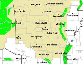
It is currently raining/freezing rain here in my little spot of the world, central AR. Thankfully here, it is barely above freezing at 33. Other parts of the state are below freezing, so it's gonna be nasty out there for them. Supposed to get above freezing over all the state later today so that will melt away any of that ice.
Ice here, not enough to cause problems.
mzkitty
I give up.
Wearing heavy jackets on beach in St. Pete. Only ice is in my fruity adult beverage. Hoping Arkansas thaws by end of week.
Chilly............

The next area of concern for freezing rain,

Mesoscale Discussion 0083
NWS Storm Prediction Center Norman OK
0917 AM CST Mon Jan 22 2024
Areas affected...portions of eastern/northeastern IL...northern
IN...far southern MI and far northwest OH
Concerning...Freezing rain
Valid 221517Z - 221915Z
SUMMARY...Light to moderate freezing rain is expected through the
morning hours with rates of 0.01-0.03 in/hr possible. Some
mixed-phase precipitation is also possible early.
DISCUSSION...As of 15 UTC, regional radar mosaic imagery and surface
observations showed a broad area of light to moderate wintry
precipitation across parts of northeastern IL. Over the last hour,
automated reports of unknown precipitation type and freezing rain
have gradually become more numerous as the precipitation has
expanded over an air mass with surface temperatures in the mid to
upper 20s F. Driven primarily by low-level warm advection, light to
moderate precipitation is expected to continue to move
east/northeast this morning. Light snow has been observed across
parts of southwest lower MI and northwest IN. However, observed and
modified model soundings show an elevated warm nose of 1-2 C between
1-2 km AGL will gradually advect northeastward over the next few
hours. While some snow and sleet are possible ahead of the main area
of precipitation, gradually deepening of the elevated warm layer to
near 600-800 m will favor a transition to predominately freezing
rain.
Rain rates of 0.01-0.03 in/hr are possible above favorable surface
temperatures for rapid ice accretion. The most likely corridor for
impactful freezing rain appears to be from northeastern IL into
northwest IN and far southwest lower MI through this morning. Hi-res
CAM guidance has been poor thus far in handling the evolution of the
precipitation field. While low-level warm advection may wane
slightly through the day, observed low and mid-level ascent appears
strong enough to continue to support precipitation into the early
afternoon. Given the cold surface temperatures and melting layer
aloft, freezing rain appears likely.
..Lyons.. 01/22/2024
packyderms_wife
Neither here nor there.
I have family in central Illinois, just south of Springfield and they are saying that it's just solid ice out there this morning.
packyderms_wife
Neither here nor there.
RT 8:47 - Max Velocity
This Winter Storm Is Getting BIGGER…
In this weather forecast, we are breaking down a WINTER STORM that will bring ice accumulation, snow, flooding rains, and isolated severe weather to the United States today, tomorrow, and Tuesday! These will impact areas like the Southern Plains, Mississippi Valley, Midwest, and Ohio Valley. This weather pattern is a part of El Nino, which has led to more active weather in the Southern Tier of the USA, while the Northern Tier has been less active. This will lead to some snow events, showers and storms, and perhaps severe weather. Find the latest details of the weather across the United States in our latest weather forecast.packyderms_wife
Neither here nor there.
Well now you know things are about to get spicy!!!
View: https://www.youtube.com/watch?v=4ghJgFJzrN8
RT 8:40 - Ryan Hall y'all xtra
RT 8:40 - Ryan Hall y'all xtra
Nonstop Storms Are About To Pop Off…
In this video we are talking about some upcoming storms that will cause some problems!packyderms_wife
Neither here nor there.
The weather guessers are calling for 0.06 inches of ice here for tomorrow, their amounts keep increasing, with possibly an inch of additional snow.

packyderms_wife
Neither here nor there.
LIVE STREAM - NWW116
LIVE COVERAGE - Tornadoes, Catastrophic Flooding & Damaging Winds Ongoing!

packyderms_wife
Neither here nor there.
RT 9:08 - Ryan Hall y'all extra
In this video, we are talking about a major storm system that will cause flooding and severe weather.
packyderms_wife
Neither here nor there.
Local news was saying that parts of Iowa might see 60F temps! Mud season has officially started.
