
You are using an out of date browser. It may not display this or other websites correctly.
You should upgrade or use an alternative browser.
You should upgrade or use an alternative browser.
WEATHER Severe Weather the Week of January 29th, 2024
- Thread starter packyderms_wife
- Start date

marsh
On TB every waking moment
Pair of major "Pineapple Express"-type atmospheric rivers to affect California Wed-Mon; elevated flood and wind risk (especially from storm #2) - Weather West
Blog updates on real-time weather, climate research, and more!
weatherwest.com
Pair of major “Pineapple Express”-type atmospheric rivers to affect California Wed-Mon; elevated flood and wind risk (especially from storm #2)
By Daniel Swain / January 29, 2024Record warmth this week will suddenly give way to pair of major storms
Well, I’ll keep this section short since there’s a lot to talk about! But most of California and indeed much of western North America has been experiencing record mid-winter warmth since the weekend–and although it’s hardly the only time California has seen multi-day stretches with record-breaking temperatures in recent years, it’s worth noting just how ho-hum these kinds of records have become as our winters continue to warm. It’s especially notable given that San Diego County saw record-breaking rainfall and severe flash flooding just last week, and that large portions of the state will be at risk of additional flooding in the coming days (with the sunny days in the 70s and locally even 80s sandwiched in between).
Storm #1 on Wed-Thu will arrive in form of warm, wet “Pineapple Express”
 This week’s dramatic pattern shift will come courtesy of a screaming zonal Pacific jet extension. This one is aimed farther south and more squarely at California than the December event, and will likely bring more significant storm activity and more widespread heavy rain/mountain snow.
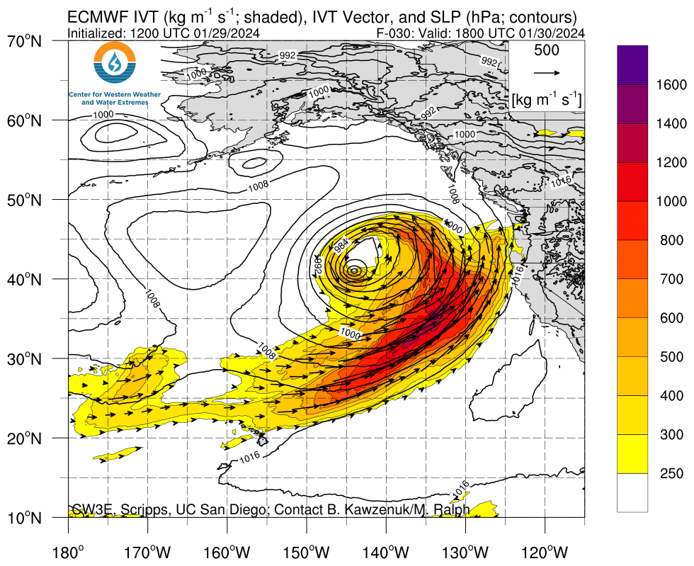
There will be two separate major storm events in the next 7 days in California, and I’ll address them each separately. The first will arrive in NorCal on Wednesday and sweep across SoCal on Thursday. This system will feature a strong atmospheric river of the “Pineapple Express” variety: it has a clear connection to subtropical moisture along a moisture transport axis extending southwestward to the Hawaiian Islands. Unsurprisingly, then, this storm will be very warm and wet in its initial stages (with high snow levels, locally very heavy downpours and isolated thunderstorms, and possibly some strong, gusty winds in NorCal). It does appear that colder air on the backside of the storm will drop snow levels considerably (below pass level and hopefully at least down to Lake Tahoe level) early enough to allow for some meaningful snow accumulation, though, later in the event.
This system has the potential to bring a 6-12 hour period of heavy to locally very heavy rainfall in NorCal on Wednesday, especially if a frontal wave can develop right as the cold front approaches the SF Bay Area (as some models are indicating). Widespread roadway and small stream flooding is likely in NorCal on Wednesday, and some smaller/faster responding rivers could potentially even briefly exceed flood stage (though probably not by a huge margin). The wildcard with such systems is always whether there’s any unpredicted stalling of the very moist frontal band; if that happens, a 50-100 mile wide corridor has the potential to see some elevated flood impacts.
This storm will hold together pretty well as it moves across SoCal, and so I expect widespread rain (heavy at times, especially mountains) on Thursday. Roadway and small stream flooding is possible in SoCal with this first event as well (though probably not major flooding), and some isolated thunderstorms/heavy downpours are plausible as well in a marginally unstable subtropical airmass.
Wednesday’s strong storm, the effects of which will likely be felt in NorCal, will be a classic warm and wet “Pineapple Express”-type atmospheric river with subtropical moisture, with snow levels starting out very high (with rain even at pass level) before falling rapidly on the backside of the storm.
Storm #2 on Sun-Tue details TBD, but also looks warm/wet & has higher ceiling on flood risk (esp. SoCal)
 Details surrounding the SundayMonday storm remain largely TBD, but all the ingredients will be in place for a potentially strong to very strong/very wet storm for the southern 2/3 of CA. Focus could be from anywhere from San Diego to San Francisco, but likely not farther north.
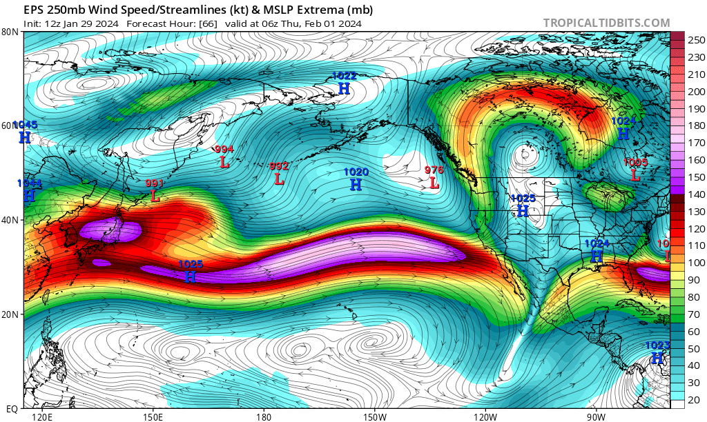
Storm #2, which will likely arrive on Sunday but may linger into Monday or even Tuesday, is still a little more uncertain but has a considerably higher ceiling in terms of rain (and wind) impacts–especially in Southern California.
This system will be positioned in an ideal configuration, relative to the screaming Pacific jet stream overhead, for rapid deepening of a surface low (or even a pair of surface lows) offshore. Additionally, this will be a low-latitude system and will be capable of tapping into not only subtropical moisture (as with the Wed storm) but maybe even deep “true” tropical moisture–which is pretty rare for California wintertime storms.
All of the ingredients–a strong, cyclonically curved jet overhead, a rapidly strengthening surface low, a deep subtropical (tropical?) moisture tap, and even some notable surface-based instability–will be in place for a potentially very high-impact storm on Sun-Mon. The details remain fuzzy, but a substantial number of the ECMWF ensemble members depict the potential for widespread very heavy precipition throughout most or all of Southern California (and possibly also Central CA as far north as the SF Bay Area) during this period along with the potential for locally damaging winds at times as the strong surface low approaches.
Will all these ingredients come together in the right spatiotemporal sequence (i.e., with the “proper phasing”) to generate a very strong/very wet storm somewhere in the southern half of California Sun-Mon? It’s too early to be entirely certain, but the odds are moderately high and increasing that some portion of the CA coast between San Diego and Monterey Bay will experience a very heavy rain event during this interval. There are some ECMWF ensemble members that depict over 10 inches near and along the Los Angeles coastal plain between Wednesday and Tuesday–just a 6 day period!While I don’t think it’s the most likely outcome, it is possible–and if it occurs, widespread and possibly serious flooding would occur across much of Southern California (not just in the mountains, but likely elsewhere as well). That outcome appears to be most likely if 1) the surface low develops near the coast and becomes quasi-stationary in a position that stalls a warm AR/cold frontal band over the Transverse Ranges of SoCal for 24 hours or more, and/or 2) if the system can tap into the deep tropical moisture reservoir (as the ECMWF currently suggests), which could generate a pretty unstable and record-moist airmass, perhaps leading to strong or even locally severe convection (thunderstorms) with embedded training cells (leading to locally major flash flooding).
It is worth noting that two locations in Southern California–Ventura back in December and San Diego just last week–have already experienced record-breaking hourly to daily-scale precipitation and severe flash flooding due to somewhat localized but extreme thunderstorm downpours this winter (each caused by the presence of an unusually warm and unstable atmosphere with a strong jet streak in just the right position overhead).
With this upcoming pattern in SoCal, there is the potential to break yet more precipitation records and perhaps even in a more widespread fashion–which is concerning partly because soils in parts of SoCal are still pretty saturated following recent downpours (despite recent record warmth). That’s quite a sequence!
Right now, I am most concerned about the potentially significant flood risk from storm #2 in SoCal, but recent model runs have suggested that the precipitation and wind risk could also spread somewhat farther northward toward the SF Bay Area. It’s difficult to know at this point which section of coast will see the greatest impacts Sun-Mon, but the details should become clearer in the next couple of days.
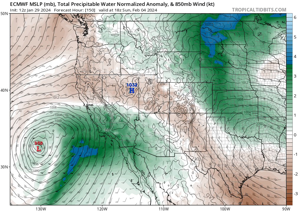
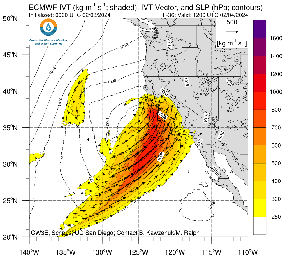
The Sunday/Monday storm is still subject to some uncertainty, but some ECMWF ensemble members are suggesting that this AR may tap not only into subtropical moisture, but maybe even deep *tropical* moisture, as depicted here in the latest ECMWF run. This could bring an extremely moist and unstable airmass to Southern California with the potential for significant flood-related impacts, though this potential outcome has only moderate likelihood at this stage. Deep tropical moisture advection is quite rare in California wintertime atmospheric rivers.
I’ve included the meteogram below (from the ECMWF ensemble and for a point near Los Angeles International airport) just to give a sense of the range of rainfall accumulations that are possible in coastal SoCal over the next week. The mean is already quite high–nearly 7 inches–but about 10% of members are depicting over 10 inches of rain during the same period along the SoCal coastal plain (!). For perspective, the average annual rainfall in Los Angeles (in lower elevation portions of the city, at least) is around 12-15 inches (depending on observing site and period of record), so there are a couple of ECMWF members depicting the city receiving nearly 100% of the annual average rainfall in a 5-6 day period (!). Again, that is not the most likely outcome, but this is an illustration of what is physically possible when a record moist airmass, unusually warm ocean temperatures, and a favorable synoptic weather pattern potentially align.
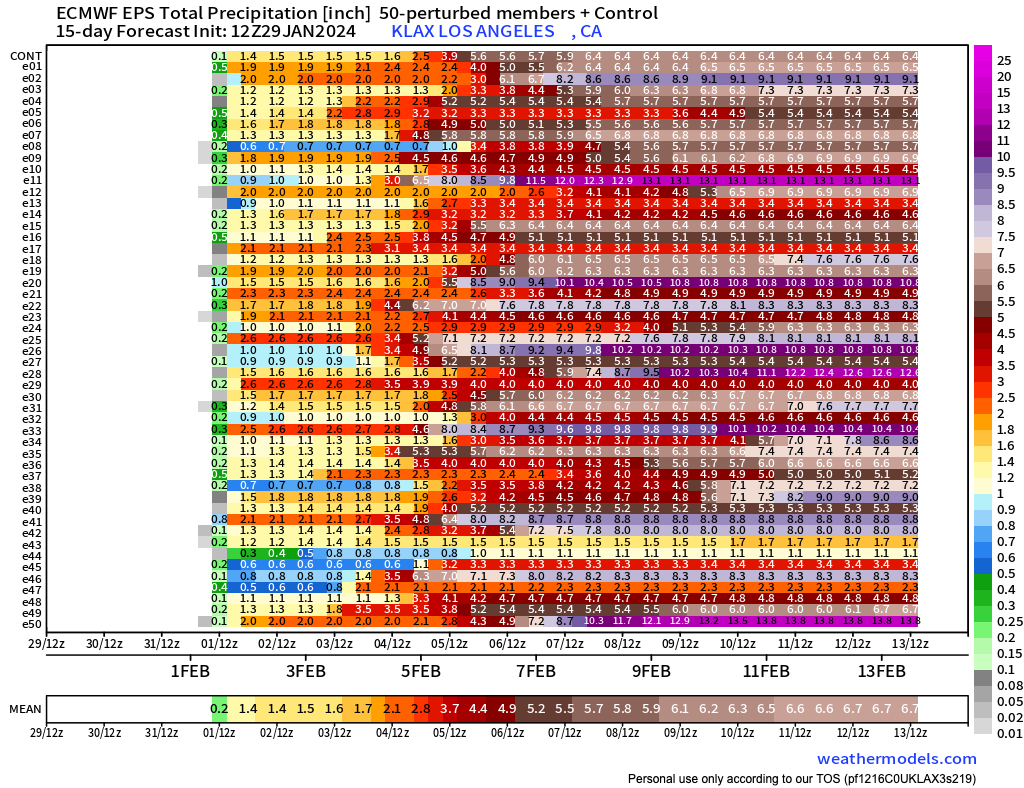
The ECMWF ensemble is currently suggesting a moderate to high potential for some very heavy rainfall across much of SoCal, mainly driven by Sun-Mon storm. This will, somewhat unusually, include lower elevations as well as mountains. Shown here are cumulative precipitation traces for a point near LAX from the latest ECMWF ensemble run, with each horizontal line representing a different model member’s predicted rainfall totals between today and mid February.
A note about El Niño and the seasonal outlook
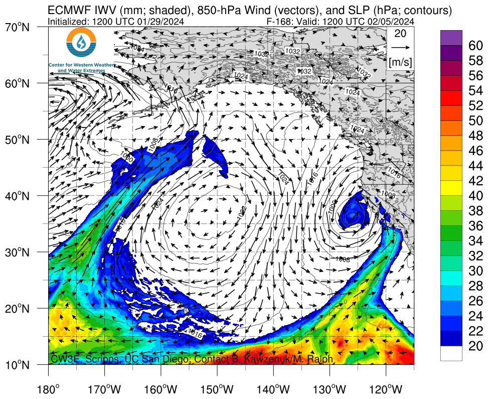
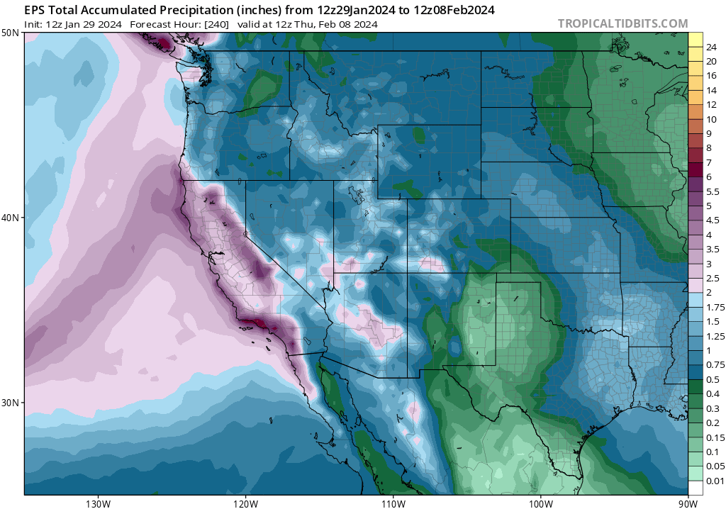 The ECMWF ensemble average is now depicting very heavy precipitation across all of coastal SoCal over the next 7-10 days, though precipitation will also be quite heavy in NorCal (it’s just slightly less unusual up there this time of year).
I won’t spend too much time belaboring the point here, because there’s more important stuff to discuss in the short term. But even assuming the ensemble average of predicted precipitation over the next 10 days, it’s likely that much of central and southern California will end up well ahead of average precipitation for the winter to date–and perhaps even above average for the entire winter season–by the end of this relatively brief storm cycle. This very wet pair of storms, enhanced by a strong and southward-shifted jet and an exceptionally moist airmass/warm coastal sea surface temperatures–is a classic strong El Niño-like pattern. It would be genuinely striking if, over the course of a single storm sequence, if parts of southern and central California surpassed their winter seasonal average precipitation in a one fell swoop.
packyderms_wife
Neither here nor there.
RT 9:03 - Ryan Hall y'all xtra
This Pineapple Express Storm Will Cause Problems…

AlaskaSue
North to the Future
-30 on a calm, sunny day. Coldest I’ve seen it in the Matanuska Valley (considered part of the ‘Alaska Banana Belt’) in many years. It was minus 30 when I got up but warmed a bit on my way to the gym. This, after many feet of snow since October (that stays on the ground until spring melt unless we get a Chinook wind). The snow piles are getting pretty high and wide from clearing the driveway…and I believe we hit a record for the area.
Pretty great winter so far!")


Pretty great winter so far!
Last edited:
packyderms_wife
Neither here nor there.
RT 8:20 - Max Velocity
In this weather forecast, we are breaking down a DIFFERENT weather pattern that we've not seen in quite some time, which is an Omega Block pattern! This will lead to much warmer weather than average, in addition to less rainfall for most of the USA. However, this will take an interesting twist because MULTIPLE storms will crash into California over the next few days, leading to some energy moving into the Southern Tier of the USA, which will lead to isolated severe weather and plenty of rainfall! These will impact areas like the Southern Plains, Mississippi Valley, Midwest, and Ohio Valley. This weather pattern is a part of El Nino, which has led to more active weather in the Southern Tier of the USA, while the Northern Tier has been less active. This will lead to some snow events, showers and storms, and perhaps severe weather. Find the latest details of the weather across the United States in our latest weather forecast
marsh
On TB every waking moment
WEATHER - Severe Weather the Week of January 29th, 2024
https://www.weather.gov/
L.A.B.
Goodness before greatness.
We’ve seen washouts of not just topsoil on hillsides, but entire root systems of the pretty low maintenance non-native as in ‘natural vegetation’ coverage, laying halfway into a two lane county hillside highway with boulders the size of a wheel.
Washouts are frequent now. So far no local asphalt or roads have been undermined. Just the mud and rock debris field strewn across it.
Washouts are frequent now. So far no local asphalt or roads have been undermined. Just the mud and rock debris field strewn across it.
Now I see forecasts of 40 to 60 mph wind for the desert. Plus the possibility of rain all week. Going to have the person feeding my cats put a large pan of dry food in the cat house because she won't come to feed in the rain. I'm scared for them.
We will get major flooding up here if even half the rain predicted falls.
We will get major flooding up here if even half the rain predicted falls.
mzkitty
I give up.

packyderms_wife
Neither here nor there.
I hate seeing stories like this cause it always ends up with a huge death toll.

marsh
On TB every waking moment

Rapidly strengthening Pacific storm to bring damaging windstorm to Central California, major flash flood risk to SoCal, and a big Sierra snowstorm - Weather West
Blog updates on real-time weather, climate research, and more!
weatherwest.com
Rapidly strengthening Pacific storm to bring damaging windstorm to Central California, major flash flood risk to SoCal, and a big Sierra snowstorm
By Daniel Swain / February 3, 2024Explosively developing low pressure system will bring rain/wind starting this evening
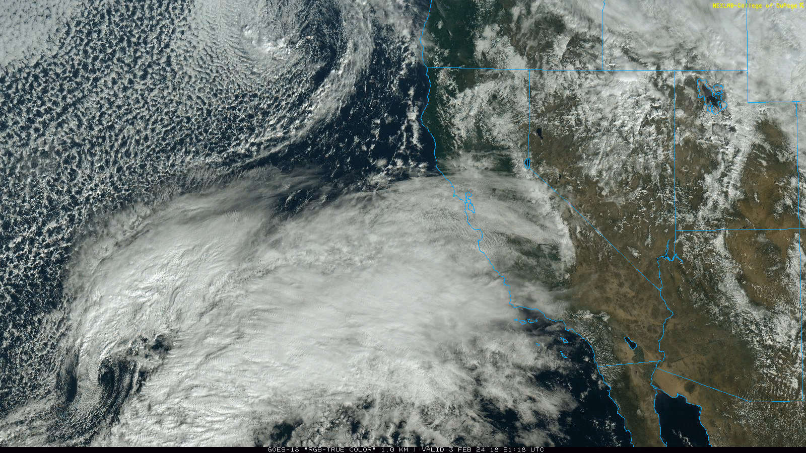
Satellite image depicting the now explosively developing low pressure center west of California. Note the classic and well-defined “baroclinic leaf” cloud to the northeast of the low pressure center. (GOES via College of Dupage)
This will be a short blog post since I was not initially planning on writing another one focused on the present storm sequence–but on rare occasions I’ll write a short-fused Weather West piece if the severity of an upcoming event justifies it. After checking the latest modeling this morning when I woke up, I think this one probably qualifies. So without any additional exposition, here’s what’s going on.
Unlike most winter storms that affect California, which more typically develop well to the west out over the open Pacific and often make landfall as they either maintain their strength or are already beginning to weaken, the storm slated to slam California starting later today will do just the opposite. This system did not really exist in coherent form out over the remote North Pacific, but is instead now rapidly developing “in situ” only 400-500 miles off the coast of central and southern California. This system will take the form of an explosively deepening surface low pressure center (or possibly a pair of similarly deep centers orbiting around a common center) just west of the Central California coast by late tonight. Several models are suggesting that this storm will meet the formal (latitude-adjusted) meteorological criteria for a “bomb cyclone” (i.e., a low pressure system that undergoes a rapid rate of deepening (at California’s latitude, around 17 mBb in 24 hours). Regardless of whether it meets the technical threshold, the main point is that this storm will be become rapidly stronger precisely at the moment it makes its closest approach to the Central Coast; this temporal evolution, plus its proximity to the coast as it does so, will greatly elevate impacts relative to more ordinary California winter storms.
Why is this storm going to be so unusual? There are a range of factors that have to line up for rapid cyclogenesis to occur close to the CA coast, and they don’t align often. One is robust “baroclinic instability”–a kind of atmospheric instability that derives from the potential energy contained by the atmospheric flow in an environment of strong horizontal air temperature differentials (this is the kind of potential energy that essentially all winter storms draw upon, but the California coast is not generally a favorable region for this to occur to a substantial degree).
Additionally, the region will be in a relatively conductive position relative to a strong Pacific jet streak aligned over Central CA. This configuration, including the presence of upper divergence, allows for “ventilation” at upper levels of the atmosphere right above the low pressure center–which facilitates deepening/evacuation of air from the low itself and enhancing its cyclonic spin. This powerful low is also tapping into some deep subtropical moisture, and the circulation around this system will aim that plume squarely at central and southern California. Due to these additional factors, this event may end up punching well above its weight on the 5-category atmospheric river scaling system.
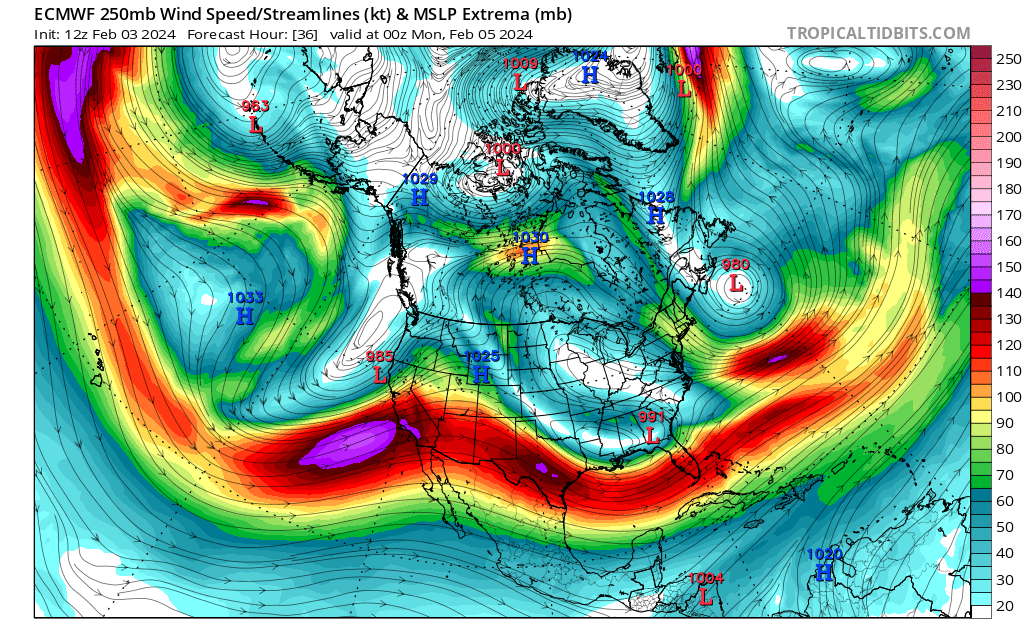
The rapidly strengthening storm will take advantage of a perfectly positioned 150+kt jet streak right overhead.
Major, damaging windstorm likely for Central Coast and possibly parts of interior NorCal
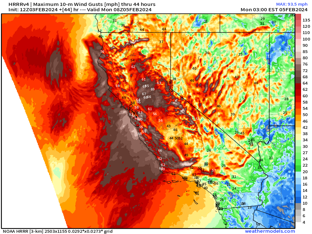
Depiction, from very high resolution HRRR model, of possible storm maximum wind gusts across California. This model depicts widespread gusts across central California in the 55-65 mph range with some well in excess of 75 mph, especially along the coast and over higher terrain. Note the 65-70 mph gusts depicted in the Sacramento Valley near the city of Sacramento.
With an explosively developing surface low expected to be located just a couple hundred miles southwest of the SF Bay Area by late tonight, a major and possibly widespread damaging windstorm will be likely along much of the Central Coast, portions of the SF Bay Area, and possibly also farther north and east (especially across the northern San Joaquin and southern/central Sacramento Valley). Models still differ as to exactly how much this low pressure center will deepen, but a ~985mb low is possible and very strong surface pressure gradients/very strong potential wind gusts will likely result along the coast from western Santa Barbara County northward toward about San Mateo County. Recent model runs suggest that very high gust potential may expand inland and northward more than previously expected (depending on the exact track of the surface low, which remains difficult to pinpoint with detail at this point), possibly affecting the northern SF Bay Area and much of the Sacramento/northern San Joaquin valleys as well. Gusty winds will be possible almost everywhere in CA with this event, but the areas highlighted above are most likely to see highly disruptive and possibly substantially damaging winds at times between this evening and Monday morning.
How high might wind gusts get in these areas? Again, there is still a substantial range–but since multiple models are now indicating gusts of 70-85 mph out over open water west of Monterey County, it’s highly plausible that gusts at least that strong could mix down to the surface near the coast and over ridgelines, and locally elsewhere in pretty widespread fashion. (A few classically windy places on more remote higher ridgelines that often see high winds could potentially see 90+ mph gusts, though gusts that high are very unlikely where people actually live.) More widespread wind gusts of 55-70 mph are likely across much of the Central Coast, SF & Monterey Bay Areas, and near the I-80 corridor in the Central Valley (including Sacramento).
Importantly, and unlike some windstorms that bring very strong winds to the coast/hills but only modest breezes elsewhere, this storm specifically has a high potential to bring widespread strong/damaging wind gusts to lower elevations. This is partly due to the enhanced convective instability associated with the low (see more below), and partly because there are indications of a possible “sting jet”-like feature potentially developing on the backside of the circulation (a narrow corridor of strong winds at higher altitudes that descends close to the surface amid subsiding air in the cool sector of a rapidly developing cyclone). Either or both of these features will have above-average potential to mix strong winds aloft closer to (or even all the way down to) the surface, especially in bands of intense rainfall.
Widespread tree and power line damage is likely in these areas, so major power outages and travel disruptions are likely. As noted: the Central Coast is almost guaranteed to experience these winds at this point, but there is more uncertainty regarding the northward and eastward extent (though most of the SF Bay Area and Sacramento area are increasingly in the crosshairs).
A strong atmospheric river, associated with both a subtropical moisture plume and a rapidly strengthening surface low, will slam central CA overnight Saturday into Sunday.
Substantial risk of major urban/flash flooding across much of SoCal (and maybe Central CA too?)
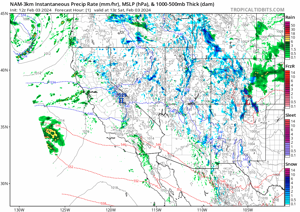
Temporal evolution, as predicted by the high-resolution NAM 3km model, of the explosively deepening storm off the California coast.
I’ll cut to the chase: this event is likely to bring widespread heavy to very heavy rainfall across all of Southern California, including the coastal plain. 3-6 inches in a 36-48 hour period is likely in most lower elevation spots (locally more possible), with at least double and perhaps triple that (9-15+ inches) in the most orographically favored parts of the Transverse Ranges. There are several additional aggravating factors that might amplify the regional flood risk even more than might otherwise be expected with these kind of rain totals. First, soils are already saturated–flooding has occurred repeatedly across portions of SoCal with recent storms, including locally damaging and even deadly flash floods in urban settings (though in localized fashion so far). Second, this storm will be notable for its intense hourly and sub-hourly rainfall rates. So rainfall intensity will be potentially very high at times, with bands of 0.5-1.0+ in/hr likely even at lower elevations (and potentially even higher intensities in the mountains). This will be caused by a combination of very high atmospheric moisture content, decent frontal forcing, and additionally some robust convective instability that will lead to some training rainbands and possibly some stronger thunderstorms (again, see below).
As the NWS in Oxnard has been messaging strongly for days, this setup is conducive to one that could produce widespread, and quite possibly major, flash flooding and urban flooding throughout a highly populated part of Southern CA. The very highest risk still appears to be along and just below the Transverse Ranges from Santa Barbara County eastward into Los Angeles County, but later in the storm major flash flood risk will likely extend farther southeastward down to San Diego county and even south of the international border. Rapid inundations of fast-responding watersheds, significant urban and roadway flooding, and possibly also debris flows will be the main threats, but larger rivers also have the potential to flood in SoCal if rainbands are espsecially persistent.
Whether this is “merely” a notable or instead becomes a genuinely historic rain/flood event in SoCal will largely come down to two factors: 1) how long the initial frontal rainband and associated atmospheric river stall perpendicular to the Transverse Ranges , and 2) whether the secondary frontal wave/low pressure system, which will mainly affect areas from LA County southeastward Mon-Tue, becomes strong enough and stalls out long enough to produce a second round of heavy to very heavy precipitation. Right now, it is difficult to tell the degree to which either of these possibilities will play out. Either way, there’s going to be a ton of rain and a lot of flooding–but just how bad it gets will likely depend on these two still uncertain factors (and also whether any really intense localized thunderstorm downpours develop.
Substantial flood risk will also arise along the Central Coast from western Santa Barbara northward to the Santa Cruz Mountains. The Big Sur coast, in particular, will be hammered by this storm and debris flows/landslides of some magnitude are likely there. Here, the combination of a high-end windstorm with locally torrential downpours will likely yield considerable disruption and possibly significant damage that takes a while to recover from.
Northward into the SF Bay Area: this will likely not be a historic rainstorm for this part of the state. However, there is the potential for very intense hourly rainfall rates at the peak of the storm even this far north–possibly coinciding with damaging wind gusts and even lightning–so this has the potential to cause significant urban flooding and widespread creek/small stream flooding even into the Bay Area although larger rivers will likely stay within their banks. This will feel like a genuinely dramatic storm from the Central Coast up through much of the SF Bay region and Sacramento area due to the combination of high winds, very intense rainbands, and possibly some stronger thunderstorms mixed in.
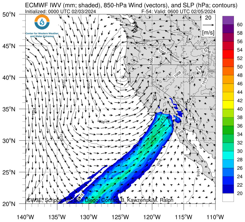
Although the horizontal vapor transport won’t be quite as strong across SoCal, an extremely moist plume will be drawn across the region for 2-3 consecutive days with very high rain accumulations possible in many areas.
Big-time Sierra snowfall (at last!) a mixed blessing, with major SWE gains but also highly disruptive accumulations
I won’t spend a whole lot of time on the specifics here–partly because there’s still considerable uncertainty in the details–but the big picture is clear: this is, finally, going to be a major snowstorm for the entire Sierra Nevada range and likely down to reasonably low elevations. Very heavy snowfall (multiple feet?) is likely at Lake Tahoe level and even below, after a winter of pretty dismal accumulations below 6,500 feet. This will be good news for snowpack and ski resorts, but will also lead to a travel nightmare and (as is the norm these days) I’d expect a lot of folks to be stuck either on the roads or at their destinations. Mountain travel Sunday and likely part of Monday will essentially be impossible due to very heavy snow and locally strong winds as well.
Severe thunderstorm risk, just to round things out?
Just in case all of the above were not enough: there is also a pretty good chance of thunderstorms with this dynamic storm, and some of them may even become strong to severe. There’s a pretty solid amount of CAPE out there (by CA standards–at least a few hundred J/kg) over the open water associated with both the cold front of the storm, its trailing cold pool, and also with the subtropical moisture plume). The strong winds aloft associated with the low itself will also offer some decent vertical wind shear, which (combined with robust upward vertical motion at synoptic scale from the broader circulation) may combine to generate some intense squall lines spiraling around the low later Saturday into Sunday. This could lead to corridors of torrential rainfall, very strong wind gusts, lightning (and perhaps even a brief waterspout/coastal tornadic spin-up from about the Monterey Bay Area southward). Not only will this activity add to the perceived “drama,” but it will also raise the odds that 1) very strong wind gusts mix down to the surface, even at lower elevations, and 2) flash flooding occurs along the Central Coast and SoCal, because these convective bands may be associated with very heavy hourly rain accumulations and could linger (“train”) over the same area for multiple hours.In sum: be careful out there, since this looks like a major, dynamic, and possibly dangerous storm that will affect many or even most Californians in the next ~48 hours. I’ll be on social media, as usual, and already have scheduled a YouTube live session for 10am Sunday but now also plan to hold another “pop-up” live session this afternoon or evening at a TBD time (so either subscribe to the YouTube channel for reminders/announcements or keep an eye on my other social media accounts for timing!).
live in 18 hours
pauldingbabe
The Great Cat
Shame all that aqua can't be captured and used.
When Reed Timmer lands in your area you know you are in trouble! I was just looking at the satellite info the weather guys have on Twitter and this storm looks like it is going to be epic! Back before the drought when the desert had big storms we placed sandbags along a fence line with shallow gully behind it now no one to do it.
My neighbor behind the property is in trouble also because that gully cuts across his property.
My neighbor behind the property is in trouble also because that gully cuts across his property.

Be careful,,friend! Any chance of you visiting your younger neighbor before the worst of it, so you're not alone? Or them, visit you?When Reed Timmer lands in your area you know you are in trouble! I was just looking at the satellite info the weather guys have on Twitter and this storm looks like it is going to be epic! Back before the drought when the desert had big storms we placed sandbags along a fence line with shallow gully behind it now no one to do it.
My neighbor behind the property is in trouble also because that gully cuts across his property.
Praying for you and your dear hubby! How is he doing, by the way?
Summerthyme
pauldingbabe
The Great Cat
Looks like a cyclone/ hurricane to me?
Hell of a storm!
Prayers for all those in the path
Hell of a storm!
Prayers for all those in the path
He is still in rehab. Some better. At least he is answering phone. Waiting for his Foot Dr to return from Africa and I really don't know anything else.Be careful,,friend! Any chance of you visiting your younger neighbor before the worst of it, so you're not alone? Or them, visit you?
Praying for you and your dear hubby! How is he doing, by the way?
Summerthyme
They need to try harder to get him walking. Friend is going to have a meeting with facility Mon.
If things go South here I'm the one with a generator so hopefully the trees don't fall on the house as people will come around here. Right now it is pretty bad. Just took a herb cocktail for my nerves. Skullcap, CA Poppy, Lemon Balm and White Willow for aches. Out of chamomile or I would have added that.