
You are using an out of date browser. It may not display this or other websites correctly.
You should upgrade or use an alternative browser.
You should upgrade or use an alternative browser.
WEATHER Severe Weather the Week of March 11th, 2024
- Thread starter packyderms_wife
- Start date

packyderms_wife
Neither here nor there.
Current Map | U.S. Drought Monitor.
US Drought Report, it's an interactive map.

 www.fireweatheravalanche.org
Wildfire map... never thought I'd be posting this one weekly.
www.fireweatheravalanche.org
Wildfire map... never thought I'd be posting this one weekly. 

 www.star.nesdis.noaa.gov
GOES Sat imagery... it's currently offline for maintenance... you can select different filter views, for dust, smoke, ash, etc
www.star.nesdis.noaa.gov
GOES Sat imagery... it's currently offline for maintenance... you can select different filter views, for dust, smoke, ash, etc
US Drought Report, it's an interactive map.
FWAC Wildfire Map - Current Wildfires, Forest Fires, and Lightning Strikes near you | Fire, Weather & Avalanche Center
Interactive real-time wildfire map for the United States, including California, Oregon, Washington, Idaho, Arizona, and others. See current wildfires and wildfire perimeters near you using the Fire, Weather & Avalanche Center Wildfire Map.
GOES Imagery Viewer - NOAA / NESDIS / STAR
Near real-time publication of GOES-East and GOES-West images from NOAA/NESDIS/STAR
packyderms_wife
Neither here nor there.
RT 8:52 - Max Velocity
In this weather forecast, we are breaking down a HUGE STORM that will bring the potential for severe weather next week and SNOW to areas in the Midwest, Ohio Valley, and Northeast United States today and tomorrow! Find the latest details of the weather across the United States in our latest weather forecast.
packyderms_wife
Neither here nor there.
RT 9:15 - Max Velocity
In this weather forecast, we are breaking down a HUGE PATTERN CHANGE that will bring the potential for severe weather this week and a COLD BLAST to areas in the Midwest, Ohio Valley, Great Plains, and Southeast United States! Find the latest details of the weather across the United States in our latest weather forecast.
packyderms_wife
Neither here nor there.
RT 8:11 Ryan Hall y'all
In this video we are talking about a big storm diving in from the NW that will cause a major weather pattern change here in the US.
packyderms_wife
Neither here nor there.
RT 10:17 - Max Velocity
This Storm Will Cause MAJOR Problems...
In this weather forecast, we are breaking down a LARGE STORM that will bring severe weather, including damaging winds, large hail, and tornadoes, this week and a COLD BLAST to areas in the Midwest, Ohio Valley, Great Plains, and Southeast United States! Find the latest details of the weather across the United States in our latest weather forecast.mzkitty
I give up.

Posted: 2:49 PM, Mar 13, 2024
Updated: 4:52 PM, Mar 13, 2024
DENVER — Denver Public Schools announced Wednesday that it will cancel classes Thursday ahead of a significant winter storm that is expected to dump a foot or more of snow in the area.
DENVER WEATHER LINKS | A complete list of closures and delays | What to expect | Radars | Traffic | Weather Page | 24/7 Weather Stream
Thursday's closure includes the Emily Griffith Technical College. All school-related events and activities, including all Discovery Link and ELCS Enrichment programs, are also canceled, the district said.
Denver’s predicted snow totals for Thursday’s storm could reach a foot or more in some locations, likely causing dangerous travel conditions in the metro and across the state.


Denver Public Schools cancels classes Thursday due to major winter storm
Denver Public Schools announced Wednesday that it will cancel classes Thursday ahead of a significant winter storm that is expected to dump a foot or more of snow in the area.
 www.denver7.com
packyderms_wife
Neither here nor there.
It's going to be in the 20's overnight this coming weekend, central Iowa. I'm not sure. how I feel about these temps, lol.
College of DuPage Meteorology
Severe Weather and Flash Flood Warnings
Note: This page will reload every 2 minutes. Warnings are listed with the most recent first.
Click on the station ID to bring up list of recent severe weather statements.
SVR T-STORM WARNING INDIANAPOLIS IN - KIND 1106 AM EDT THU MAR 14 2024
SVR T-STORM WARNING INDIANAPOLIS IN - KIND 1048 AM EDT THU MAR 14 2024
SVR T-STORM WARNING LINCOLN IL - KILX 943 AM CDT THU MAR 14 2024
SVR T-STORM WARNING INDIANAPOLIS IN - KIND 1037 AM EDT THU MAR 14 2024
SVR T-STORM WARNING LINCOLN IL - KILX 927 AM CDT THU MAR 14 2024
SVR T-STORM WARNING NORTHERN INDIANA - KIWX 1022 AM EDT THU MAR 14 2024
SVR T-STORM WARNING LINCOLN IL - KILX 854 AM CDT THU MAR 14 2024
SVR T-STORM WARNING LINCOLN IL - KILX 826 AM CDT THU MAR 14 2024
SVR T-STORM WARNING ST LOUIS MO - KLSX 826 AM CDT THU MAR 14 2024
TORNADO WARNING LINCOLN IL - KILX 823 AM CDT THU MAR 14 2024
SVR T-STORM WARNING ST LOUIS MO - KLSX 819 AM CDT THU MAR 14 2024
TORNADO WARNING ST LOUIS MO - KLSX 815 AM CDT THU MAR 14 2024
packyderms_wife
Neither here nor there.
LIVE STREAM - Max Velocity
In this live stream, we are breaking down ongoing severe weather in the United States. This severe weather event could bring significant damaging winds, large hail, and tornadoes. This is a live weather channel.
packyderms_wife
Neither here nor there.
We had some rain here overnight, central Iowa, and it's so dry here that the ground was bone dry when I got up. Supposed to rain off and on all afternoon. I see Colorado got hammered with snow.

packyderms_wife
Neither here nor there.
Tornado Warning
OKC091-107-111-141845-
/O.NEW.KTSA.TO.W.0004.240314T1819Z-240314T1845Z/
BULLETIN - EAS ACTIVATION REQUESTED
Tornado Warning
National Weather Service Tulsa OK
119 PM CDT Thu Mar 14 2024
The National Weather Service in Tulsa has issued a
* Tornado Warning for...
Northwestern McIntosh County in southeastern Oklahoma...
Southwestern Okmulgee County in northeastern Oklahoma...
Southeastern Okfuskee County in east central Oklahoma...
* Until 145 PM CDT.
* At 119 PM CDT, a severe thunderstorm capable of producing a tornado
was located near Pharoah, moving east at 55 mph.
HAZARD...Tornado and golf ball size hail.
SOURCE...Radar indicated rotation.
IMPACT...Flying debris will be dangerous to those caught without
shelter. Mobile homes will be damaged or destroyed.
Damage to roofs, windows, and vehicles will occur. Tree
damage is likely.
* Locations in or near the path include...
Henryetta... Weleetka...
Dewar... Schulter...
Grayson... Hoffman...
Clearview... Stidham...
Pharoah... Hitchita...
Bryant... Pierce...
This includes Interstate 40 in Oklahoma between mile markers 226 and
256.
PRECAUTIONARY/PREPAREDNESS ACTIONS...
TAKE COVER NOW! Move to a basement or an interior room on the lowest
floor of a sturdy building. Avoid windows. If you are outdoors, in a
mobile home, or in a vehicle, move to the closest substantial shelter
and protect yourself from flying debris.
&&
LAT...LON 3552 9608 3555 9571 3555 9565 3530 9565
3529 9598 3529 9618 3546 9621
TIME...MOT...LOC 1819Z 260DEG 47KT 3538 9610
TORNADO...RADAR INDICATED
MAX HAIL SIZE...1.75 IN
$$
packyderms_wife
Neither here nor there.
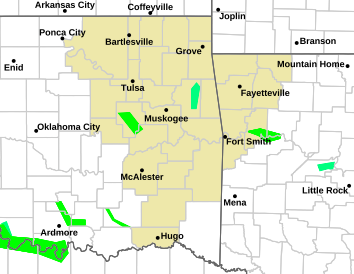
Oklahoma

packyderms_wife
Neither here nor there.
LIVE STREAM - Ryan Hall y'all
LIVE - Tornado Coverage With Storm Chasers On The Ground - Live Weather Channel.
packyderms_wife
Neither here nor there.
INDIANA
Severe Weather Statement
National Weather Service Louisville KY
221 PM EDT Thu Mar 14 2024
INC077-141831-
/O.EXP.KLMK.TO.W.0003.000000T0000Z-240314T1830Z/
Jefferson IN-
221 PM EDT Thu Mar 14 2024
...THE TORNADO WARNING FOR SOUTHEASTERN JEFFERSON COUNTY WILL EXPIRE
AT 230 PM EDT...
The storm which prompted the warning has moved out of the area.
Therefore, the warning will be allowed to expire.
To report severe weather, contact your nearest law enforcement
agency. They will relay your report to the National Weather Service
Louisville.
LAT...LON 3869 8520 3870 8522 3873 8525 3875 8525
3875 8520
TIME...MOT...LOC 1821Z 267DEG 39KT 3871 8517
$$
RJS
packyderms_wife
Neither here nor there.
IN/KY/OH area

packyderms_wife
Neither here nor there.
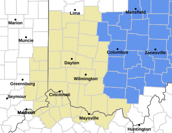
Indiana/Kentucky
Tornado Warning
INC155-KYC041-077-187-141900-
/O.NEW.KILN.TO.W.0008.240314T1824Z-240314T1900Z/
BULLETIN - EAS ACTIVATION REQUESTED
Tornado Warning
National Weather Service Wilmington OH
224 PM EDT Thu Mar 14 2024
The National Weather Service in Wilmington has issued a
* Tornado Warning for...
Central Switzerland County in southeastern Indiana...
Eastern Carroll County in northern Kentucky...
Northwestern Owen County in northern Kentucky...
Gallatin County in northern Kentucky...
* Until 300 PM EDT.
* At 224 PM EDT, a severe thunderstorm capable of producing a tornado
was located over Carrollton, moving east at 45 mph.
HAZARD...Tornado and hail up to two inches in diameter.
SOURCE...Radar indicated rotation.
IMPACT...Flying debris will be dangerous to those caught without
shelter. Mobile homes will be damaged or destroyed.
Damage to roofs, windows, and vehicles will occur. Tree
damage is likely.
* Locations impacted include...
Carrollton, Vevay, Warsaw, Florence, Kentucky Speedway, Glencoe,
Ghent, Sanders, Sparta, Ethridge, Interstate 71 at Mile Marker 52,
Interstate 71 at US Route 127, Long Ridge, Markland, New Liberty,
Eagle Hill, Eagle Station, Easterday, Mount Sterling, and Egypt
Bottom.
This includes I-71 in Kentucky between mile markers 46 and 64.
PRECAUTIONARY/PREPAREDNESS ACTIONS...
TAKE COVER NOW! Move to a basement or an interior room on the lowest
floor of a sturdy building. Avoid windows. If you are outdoors, in a
mobile home, or in a vehicle, move to the closest substantial shelter
and protect yourself from flying debris.
To report severe weather, go to our website at weather.gov/iln and
submit your report via social media, when you can do so safely.
&&
LAT...LON 3882 8513 3882 8484 3873 8478 3858 8481
3866 8513
TIME...MOT...LOC 1824Z 282DEG 37KT 3870 8512
TORNADO...RADAR INDICATED
MAX HAIL SIZE...2.00 IN
$$
Hatzos
Tornado Warning
INC155-KYC041-077-187-141900-
/O.NEW.KILN.TO.W.0008.240314T1824Z-240314T1900Z/
BULLETIN - EAS ACTIVATION REQUESTED
Tornado Warning
National Weather Service Wilmington OH
224 PM EDT Thu Mar 14 2024
The National Weather Service in Wilmington has issued a
* Tornado Warning for...
Central Switzerland County in southeastern Indiana...
Eastern Carroll County in northern Kentucky...
Northwestern Owen County in northern Kentucky...
Gallatin County in northern Kentucky...
* Until 300 PM EDT.
* At 224 PM EDT, a severe thunderstorm capable of producing a tornado
was located over Carrollton, moving east at 45 mph.
HAZARD...Tornado and hail up to two inches in diameter.
SOURCE...Radar indicated rotation.
IMPACT...Flying debris will be dangerous to those caught without
shelter. Mobile homes will be damaged or destroyed.
Damage to roofs, windows, and vehicles will occur. Tree
damage is likely.
* Locations impacted include...
Carrollton, Vevay, Warsaw, Florence, Kentucky Speedway, Glencoe,
Ghent, Sanders, Sparta, Ethridge, Interstate 71 at Mile Marker 52,
Interstate 71 at US Route 127, Long Ridge, Markland, New Liberty,
Eagle Hill, Eagle Station, Easterday, Mount Sterling, and Egypt
Bottom.
This includes I-71 in Kentucky between mile markers 46 and 64.
PRECAUTIONARY/PREPAREDNESS ACTIONS...
TAKE COVER NOW! Move to a basement or an interior room on the lowest
floor of a sturdy building. Avoid windows. If you are outdoors, in a
mobile home, or in a vehicle, move to the closest substantial shelter
and protect yourself from flying debris.
To report severe weather, go to our website at weather.gov/iln and
submit your report via social media, when you can do so safely.
&&
LAT...LON 3882 8513 3882 8484 3873 8478 3858 8481
3866 8513
TIME...MOT...LOC 1824Z 282DEG 37KT 3870 8512
TORNADO...RADAR INDICATED
MAX HAIL SIZE...2.00 IN
$$
Hatzos
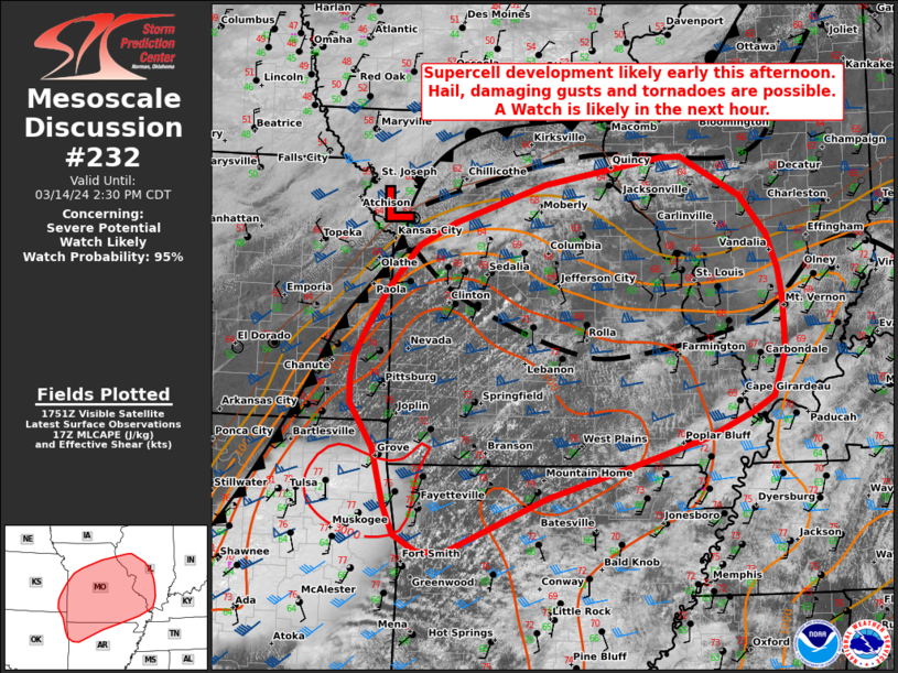
Storm Prediction Center Mesoscale Discussion 232
Severe weather, tornado, thunderstorm, fire weather, storm report, tornado watch, severe thunderstorm watch, mesoscale discussion, convective outlook products from the Storm Prediction Center.
www.spc.noaa.gov


Last edited:
packyderms_wife
Neither here nor there.
starting to look like we might see an outbreak today.
psychgirl
Has No Life - Lives on TB
Round one hit here fast and hard.INDIANA
Severe Weather Statement
National Weather Service Louisville KY
221 PM EDT Thu Mar 14 2024
INC077-141831-
/O.EXP.KLMK.TO.W.0003.000000T0000Z-240314T1830Z/
Jefferson IN-
221 PM EDT Thu Mar 14 2024
...THE TORNADO WARNING FOR SOUTHEASTERN JEFFERSON COUNTY WILL EXPIRE
AT 230 PM EDT...
The storm which prompted the warning has moved out of the area.
Therefore, the warning will be allowed to expire.
To report severe weather, contact your nearest law enforcement
agency. They will relay your report to the National Weather Service
Louisville.
LAT...LON 3869 8520 3870 8522 3873 8525 3875 8525
3875 8520
TIME...MOT...LOC 1821Z 267DEG 39KT 3871 8517
$$
RJS
Round two is this evening
I just heard Madison, Indiana had a tornado touchdown, waiting for more
medic38572
TB Fanatic
Ryan Hall is live now from Oklahoma to Kentucky Storms and tornados popping up. Chasers on the ground.
View: https://www.youtube.com/watch?v=kpNdqwioL54
RT- Presently live
RT- Presently live
17 chasers out, 15 streaming.

 zoomradar.com
8 streaming, crapton out.
 livestormchasing.com
ZoomRadar – Interactive Weather For Your Website
ZoomRadar is one of the fastest updating interactive radars on the web, aggregating local Level 2 Doppler radars from all across the US
8 streaming, crapton out.
Live Storm Chasing
Watch live feeds as storm chasers try to see if their target verifies. Tornadoes, hurricanes, blizzards, and floods - we've got it all and more, live on our site and available as video on demand.
packyderms_wife
Neither here nor there.
Hatzos
Tornado Warning
KYC077-081-187-141915-
/O.NEW.KILN.TO.W.0009.240314T1840Z-240314T1915Z/
BULLETIN - EAS ACTIVATION REQUESTED
Tornado Warning
National Weather Service Wilmington OH
240 PM EDT Thu Mar 14 2024
The National Weather Service in Wilmington has issued a
* Tornado Warning for...
Grant County in northern Kentucky...
Northeastern Owen County in northern Kentucky...
Central Gallatin County in northern Kentucky...
* Until 315 PM EDT.
* At 240 PM EDT, a severe thunderstorm capable of producing a tornado
was located over Kentucky Speedway, moving east at 40 mph.
HAZARD...Tornado and tennis ball size hail.
SOURCE...Radar indicated rotation.
IMPACT...Flying debris will be dangerous to those caught without
shelter. Mobile homes will be damaged or destroyed.
Damage to roofs, windows, and vehicles will occur. Tree
damage is likely.
* Locations impacted include...
Williamstown, Crittenden, Dry Ridge, Glencoe, Sparta, Munk,
Stewartsville, Cherry Grove, Northcutt, Interstate 71 at US Route
127, Williamstown Lake, New Liberty, Eagle Hill, Napoleon, Twin
Bridges, Needmore, Holbrook, Sherman, Elliston, and Lawrenceville.
This includes the following Interstates...
I-71 in Kentucky between mile markers 57 and 68.
I-75 in Kentucky between mile markers 151 and 166.
PRECAUTIONARY/PREPAREDNESS ACTIONS...
TAKE COVER NOW! Move to a basement or an interior room on the lowest
floor of a sturdy building. Avoid windows. If you are outdoors, in a
mobile home, or in a vehicle, move to the closest substantial shelter
and protect yourself from flying debris.
To report severe weather, go to our website at weather.gov/iln and
submit your report via social media, when you can do so safely.
&&
LAT...LON 3862 8493 3877 8489 3878 8482 3880 8481
3879 8469 3878 8466 3878 8465 3879 8465
3879 8453 3859 8449 3856 8471
TIME...MOT...LOC 1840Z 278DEG 35KT 3870 8489
TORNADO...RADAR INDICATED
MAX HAIL SIZE...2.50 IN
$$
Hatzos


mzkitty
I give up.


Much more here:
News about #tornado on Twitter
13h ago @JoshFitzWx tweeted: "Easter storms sweep South, killing at le.." - read what others are saying and join the conversation.
packyderms_wife
Neither here nor there.
Tornado Warning
ARC007-142000-
/O.NEW.KTSA.TO.W.0006.240314T1923Z-240314T2000Z/
BULLETIN - EAS ACTIVATION REQUESTED
Tornado Warning
National Weather Service Tulsa OK
223 PM CDT Thu Mar 14 2024
The National Weather Service in Tulsa has issued a
* Tornado Warning for...
Northwestern Benton County in northwestern Arkansas...
* Until 300 PM CDT.
* At 223 PM CDT, a severe thunderstorm capable of producing a tornado
was located over Gravette, moving east at 35 mph.
HAZARD...Tornado and baseball size hail.
SOURCE...Radar indicated rotation.
IMPACT...Flying debris will be dangerous to those caught without
shelter. Mobile homes will be damaged or destroyed.
Damage to roofs, windows, and vehicles will occur. Tree
damage is likely.
* Locations in or near the path include...
Rogers... Bentonville...
Bella Vista... Pea Ridge...
Gravette... Decatur...
Hiwasse... Miller...
Centerton...
This includes Interstate 49 between mile markers 86 and 93.
PRECAUTIONARY/PREPAREDNESS ACTIONS...
TAKE COVER NOW! Move to a basement or an interior room on the lowest
floor of a sturdy building. Avoid windows. If you are outdoors, in a
mobile home, or in a vehicle, move to the closest substantial shelter
and protect yourself from flying debris.
&&
LAT...LON 3635 9408 3633 9448 3650 9455 3650 9408
TIME...MOT...LOC 1923Z 258DEG 31KT 3643 9444
TORNADO...RADAR INDICATED
MAX HAIL SIZE...2.75 IN
$$
packyderms_wife
Neither here nor there.

Arkansas Oklahoma Missouri
SouthernBreeze
Has No Life - Lives on TB
I've been watching this storm system develop. It appears not to be a threat to Mississippi, or is it? This time of year, we can't afford to be inattentive to the weather.
Countrymouse
Country exile in the city
Some BAD juju going on right now near St. Louis MO--
TORNADOES
Ryan Hall is LIVE:
View: https://www.youtube.com/watch?v=kpNdqwioL54
TORNADOES
Ryan Hall is LIVE:
packyderms_wife
Neither here nor there.
Guys if you look up thread you'll see that in post #17 Ryans video was posted.
packyderms_wife
Neither here nor there.
Tornado Warning
MOC099-142145-
/O.NEW.KLSX.TO.W.0008.240314T2101Z-240314T2145Z/
BULLETIN - EAS ACTIVATION REQUESTED
Tornado Warning
National Weather Service St Louis MO
401 PM CDT Thu Mar 14 2024
The National Weather Service in St Louis has issued a
* Tornado Warning for...
Central Jefferson County in east central Missouri...
* Until 445 PM CDT.
* At 401 PM CDT, a severe thunderstorm capable of producing a tornado
was located over Hillsboro, moving east at 30 mph.
HAZARD...Tornado and golf ball size hail.
SOURCE...Radar indicated rotation.
IMPACT...Flying debris will be dangerous to those caught without
shelter. Mobile homes will be damaged or destroyed.
Damage to roofs, windows, and vehicles will occur. Tree
damage is likely.
* This dangerous storm will be near...
Hillsboro around 405 PM CDT.
Horine around 410 PM CDT.
Festus, Pevely, Crystal City, and Herculaneum around 415 PM CDT.
Other locations in the path of this tornadic thunderstorm include
Barnhart and Imperial.
This also includes Sandy Creek Covered Bridge Historic Site and Gov.
Dunklin`s Grave Historic Site.
This includes Interstate 55 in Missouri between exits 174 and 187.
PRECAUTIONARY/PREPAREDNESS ACTIONS...
TAKE COVER NOW! Move to a basement or an interior room on the lowest
floor of a sturdy building. Avoid windows. If you are outdoors, in a
mobile home, or in a vehicle, move to the closest substantial shelter
and protect yourself from flying debris.
&&
LAT...LON 3818 9066 3828 9068 3838 9035 3834 9037
3828 9037 3822 9036 3819 9034 3817 9030
TIME...MOT...LOC 2101Z 249DEG 24KT 3822 9059
TORNADO...RADAR INDICATED
MAX HAIL SIZE...1.75 IN
$$
Glass


patriotgal
Veteran Member
High winds and lost power for a bit. I hear there are lots of trees down. We have some huge trees and they were dipping and swaying. Worst has passed. Birds are talking outside again. North central Arkansas.
packyderms_wife
Neither here nor there.
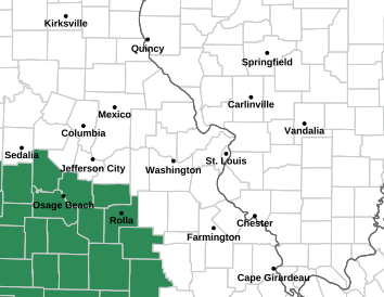
Missouri and Illinois

