
You are using an out of date browser. It may not display this or other websites correctly.
You should upgrade or use an alternative browser.
You should upgrade or use an alternative browser.
WEATHER Severe Weather Thread the week of January 1st 2024!!!
- Thread starter packyderms_wife
- Start date

packyderms_wife
Neither here nor there.
Now the strongest event of the current solar cycle, A major X5.0 solar flare was just observed around AR 3536 (ex 3514). More to follow!
SolarHam.com
SolarHam.com
packyderms_wife
Neither here nor there.
RT 3:11 SuspiciousObservers
X5 Solar Flare, Big Earthquake Japan, Top Stories | S0 News Jan.1.2024
Walbash
Contributing Member
The Biggest Storms Of The Year Are Coming…
Ryan Hall update on the weather for the next week and a halfRT 12:48
marsh
On TB every waking moment
Millions Brace For Northeast's Biggest Snowstorm In Years | ZeroHedge
ZeroHedge - On a long enough timeline, the survival rate for everyone drops to zero
 www.zerohedge.com
Millions Brace For Northeast's Biggest Snowstorm In Years
FRIDAY, JAN 05, 2024 - 04:20 PMMillions of Americans from the Carolinas to Maine are under winter weather alerts ahead of what could be the biggest snowstorm to hit the Mid-Atlantic and Northeast in at least a year.
The storm is developing on Friday along the Gulf Coast. According to computer forecast models, major cities along the Northeast's I-95 corridor will likely escape the brunt of the snowstorm (not what snow lovers want to hear). However, regions in the Interior Northeast could see upwards of 12 inches of snow.
The system will traverse the Southeast and into the mid-Atlantic Friday into Saturday. Snow, sleet, and rain are expected across the Atlantic region on Saturday, quickly changing to rain from DC to Baltimore to Philadelphia to New York City. Some metro areas along the I-95 might record an inch of snow.
The good news is that a multi-year snow drought could end across some of the Mid-Atlantic and Northeast metro areas.
Areas north and west of the DC to Baltimore to Philadelphia to NYC could record 4 to 8 inches of snow, with isolated amounts over a foot.
View: https://twitter.com/HenryMargusity/status/1743296310717960220?ref_src=twsrc%5Etfw%7Ctwcamp%5Etweetembed%7Ctwterm%5E1743296310717960220%7Ctwgr%5E6f783a0adad2f44f28a562d891e3589150edab53%7Ctwcon%5Es1_&ref_url=https%3A%2F%2Fwww.zerohedge.com%2Fweather%2Fmillions-brace-northeasts-biggest-snowstorm-years
Rob Carolan, owner of Hometown Forecast Services, told Bloomberg that rain is expected to start in New York City late Saturday, with the storm strengthening overnight. He said northern New Jersey, the Hudson Valley, and parts of Connecticut might see 2 to 6 inches of snow, adding Upstate New York and interior New England could see upwards of 10 inches.
Carolan said, "It is the best snowfall we have seen in over a year in many of these locations."
We noted on Monday, "First Time In Nearly 2 Years": Snow Drought In Major US Northeast Cities May End Soon, and published a note this morning about an incoming cold blast for the Lower 48 later this month.
Is there another storm forecasted for next week?
View: https://twitter.com/tropicalupdate/status/1743304986119876970?ref_src=twsrc%5Etfw%7Ctwcamp%5Etweetembed%7Ctwterm%5E1743304986119876970%7Ctwgr%5E6f783a0adad2f44f28a562d891e3589150edab53%7Ctwcon%5Es1_&ref_url=https%3A%2F%2Fwww.zerohedge.com%2Fweather%2Fmillions-brace-northeasts-biggest-snowstorm-years
Thank you, El Nino.
Stay safe!
Summerthyme
Summerthyme
patriotgal
Veteran Member
28 deg this am with a mix of sleet, snow and rain. Still dripping and cold. Probably gonna be slick tomorrow.
Plain Jane
Just Plain Jane
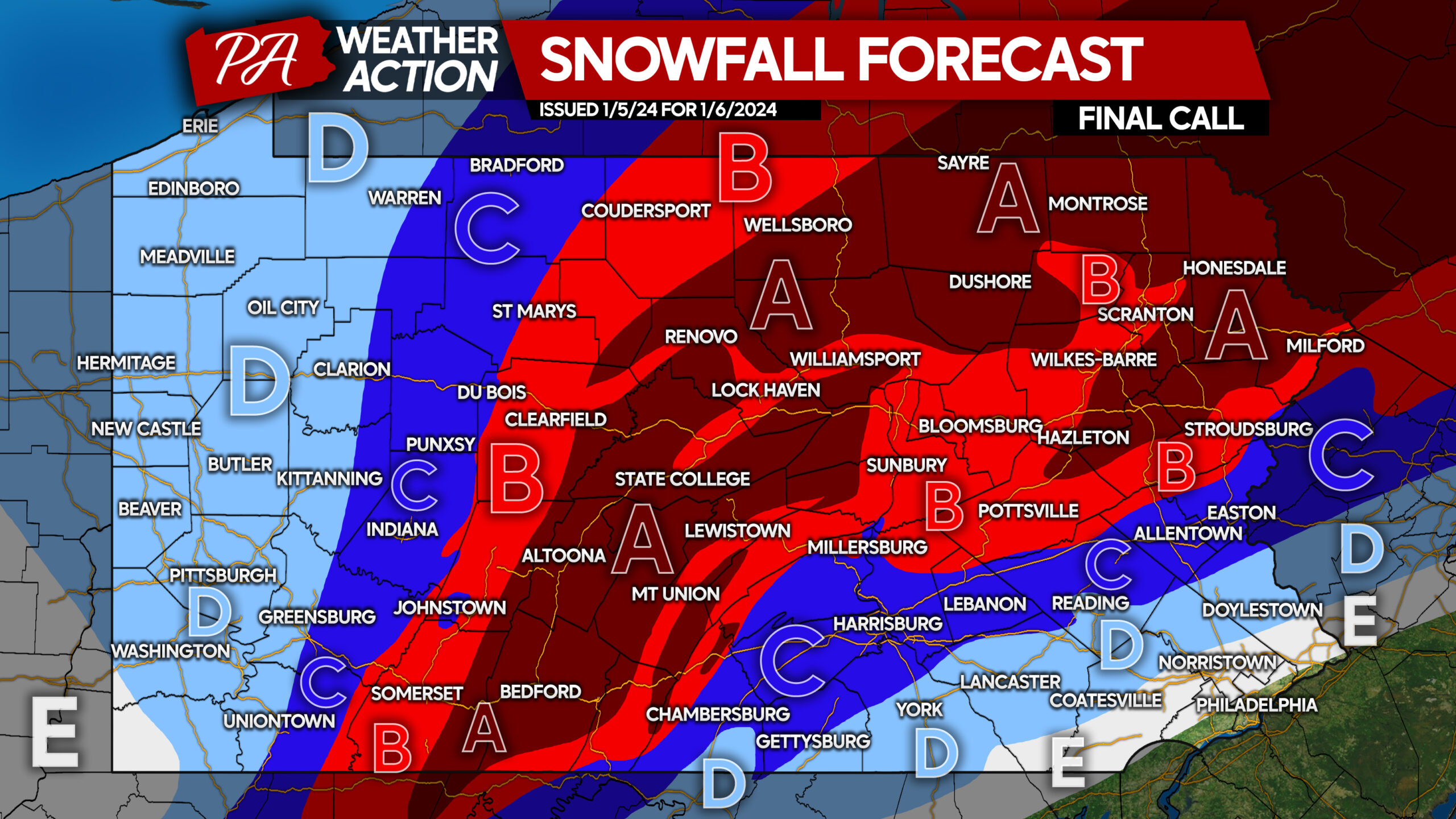
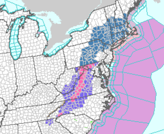
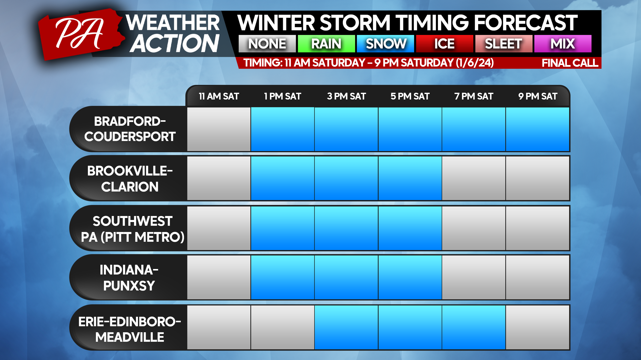
Final Call Snowfall Forecast for Saturday’s Significant Snowstorm in Pennsylvania
Our long-awaited snowstorm is nearly here, and in the last 24 hours since our second call, there have been some changes to increase expected snowfall in much of Central and Western PA. As usual, the most complicated, high stakes area is where rain and sleet will mix in, which is across South...
 paweatheraction.com
FINAL CALL SNOWFALL FORECAST FOR SATURDAY’S SIGNIFICANT SNOWSTORM IN PENNSYLVANIA
Jan52024
StatewideWinter Weather
Our long-awaited snowstorm is nearly here, and in the last 24 hours since our second call, there have been some changes to increase expected snowfall in much of Central and Western PA. As usual, the most complicated, high stakes area is where rain and sleet will mix in, which is across South Central and Southeast PA. There will almost certainly be a few surprises in those areas, in the form of a bit more or less snow than anticipated. Both areas where 6-8″ and 8-12″ are expected have dramatically increased in size, which you will see below. Timing has also moved up a fair amount, so please view the latest time tables below.
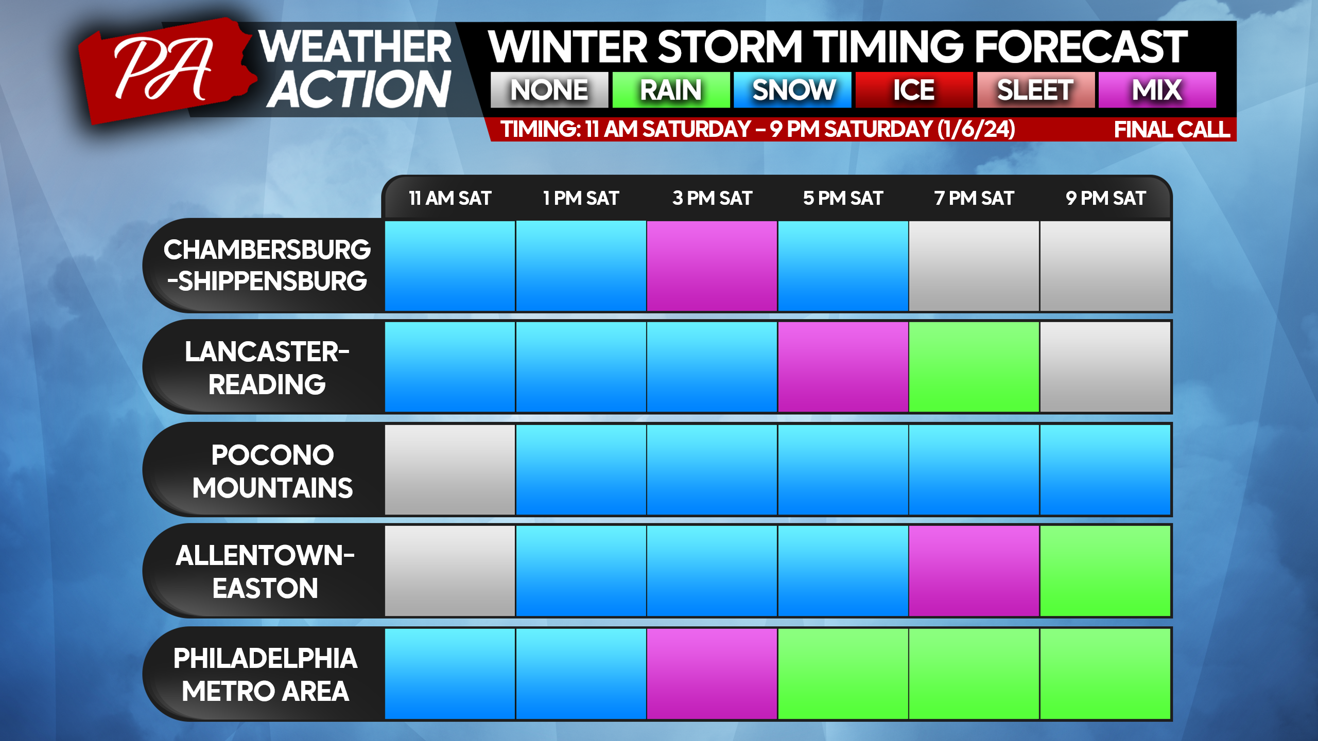
STORM IMPACT TIME TABLES
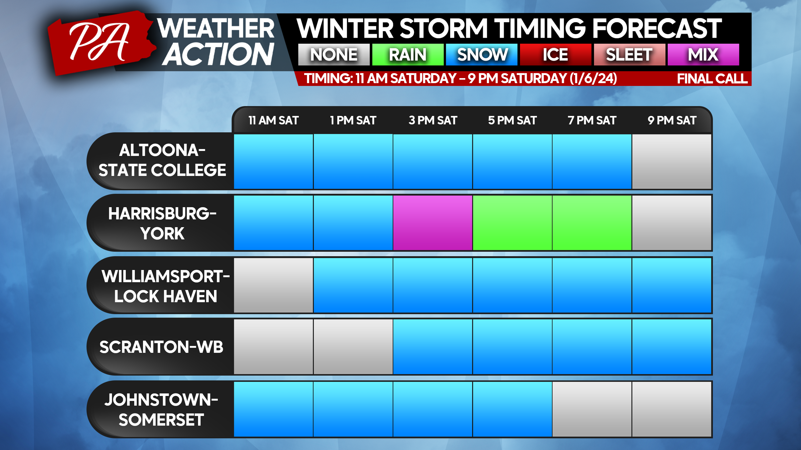
FINAL CALL SNOWFALL FORECAST FOR SATURDAY’S SIGNIFICANT SNOWSTORM
Area A: Snowfall accumulation of 8 – 12″ expected. All snow expected, with rates often above 1″ per hour. Do not travel during storm.
Area B: Snowfall accumulation of 6 – 8″ expected. All snow expected, with rates often above 1″ per hour. Do not travel during storm.
Area C: Snowfall accumulation of 4 – 6″ expected. Southern areas near I-81 and I-78 will begin as snow, followed by a brief wintry mix before ending as snow. Snowfall rates at onset above 1″ per hour, no not travel during that period.
Area D: Snowfall accumulation of 2 – 4″ expected. Southern areas will begin as snow before changing to a long period of wintry mix and rain. Snowfall rates above 1″ per hour at onset, limit travel during that period.
Area E: Snowfall accumulation of 1 – 2″ expected. Southern areas will briefly begin as snow before changing to rain.
Don’t forget to share this forecast with family and friends below!
bracketquant
Veteran Member
Here, in the Connecticut River valley, it's an estimated 5-8 inches. 15 miles to the west and 15 miles to the east, the estimate is 8-12 inches.
Neither is a big deal, so long as it's not a heavy wet snow to clog up the snowblower.
Neither is a big deal, so long as it's not a heavy wet snow to clog up the snowblower.
Next Friday, they're guessing a few inches with single digit lows.
A few days below freezing.
"Scuse me, while I wander off to a happy place.

A few days below freezing.
"Scuse me, while I wander off to a happy place.


Plain Jane
Just Plain Jane
North Central PA - We had a brief snow shower a few hours ago but the sustained snow will soon begin. 6-8 inches are expected through tomorrow.
Meemur
Voice on the Prairie / FJB!
Yep! Hunker down, drink Pepsi, and eat pizza . . . isn't that what Frankie MacDonald used to say?
RT: 1 minute
View: https://www.youtube.com/watch?v=f6YIo_QAtDY
RT: 1 minute
packyderms_wife
Neither here nor there.
Cousin of mine, who lives south of Saint Louis, MO, woke up to snow this morning, kinda jealous would love to have some snow.
packyderms_wife
Neither here nor there.
RT 9:58 - Max Velocity
In this weather forecast, we are breaking down the threat of multiple WINTER STORMS in January. These will impact areas like the Midwest, Central Plains, Northeast, and Mid-Atlantic. This weather pattern is a part of El Nino, which will lead to more active weather in the Southern Tier of the USA, while the Northern Tier will be quite inactive. This will lead to some snow events, showers and storms, and perhaps severe weather. Find the latest details of the weather across the United States in our latest weather forecast.
So far we have collected 3" inches of the white fluffy stuff we call snow and started coming down faster/harder.
At my location radar is showing this storm coming up from the south and traveling north to northeast.
In West Virginia Snowshoe and Canaan Valley looks to be open for skying.
At my location radar is showing this storm coming up from the south and traveling north to northeast.
In West Virginia Snowshoe and Canaan Valley looks to be open for skying.
Last edited:
We're around the southern edge of the white band.
WUnderground keeps bouncing our forecast around.
It goes from miserable to slightly less miserable and back down again.
WUnderground keeps bouncing our forecast around.
It goes from miserable to slightly less miserable and back down again.
Current area of concern,
Mesoscale Discussion 6

Mesoscale Discussion 0006
NWS Storm Prediction Center Norman OK
1047 AM CST Sat Jan 06 2024
Areas affected...Central/Southern PA...Eastern WV
Panhandle...Western/Central MD...Far Northern VA
Concerning...Heavy snow
Valid 061647Z - 062145Z
SUMMARY...Snowfall rates are expected to increase across the region
over the next several hours. Rates around 1"/hr are likely across
much of the area, with localized 2"/hr rate possible, particularly
across south-central PA.
DISCUSSION...Recent satellite imagery shows a low-amplitude
shortwave trough over eastern TN, moving quickly northeastward.
Regional radar imagery shows a large area of precipitation across
the Mid-Atlantic and into southern portions of the Northeast, within
the warm conveyor preceding this shortwave. Attendant low-level flow
is forecast to strengthen over the next several hours as the
shortwave continues northeastward. Additionally, the attendant
surface low, which is currently over south-central NC, is expected
to deepen over the next few hours as it moves northeastward across
central NC and southeast VA.
These factors will result in an area of strong low-level
frontogenesis over VA, with associated lift focused into
central/southern PA, the eastern WV Panhandle, western/central MD,
and far northern VA. Most of this area is currently experiencing
moderate snow, but snowfall rates are expected to increase over the
next few hours as the evolution described above occurs. Rates around
1"/hr are likely across much of the area, with some areas
experiencing 2"/hr, particularly south-central PA where banding
appears most likely. Highest rates are expected to be centered
around 20Z, with rates then likely diminishing over this area as the
shortwave continues northeastward.
..Mosier.. 01/06/2024
Mesoscale Discussion 6
Mesoscale Discussion 0006
NWS Storm Prediction Center Norman OK
1047 AM CST Sat Jan 06 2024
Areas affected...Central/Southern PA...Eastern WV
Panhandle...Western/Central MD...Far Northern VA
Concerning...Heavy snow
Valid 061647Z - 062145Z
SUMMARY...Snowfall rates are expected to increase across the region
over the next several hours. Rates around 1"/hr are likely across
much of the area, with localized 2"/hr rate possible, particularly
across south-central PA.
DISCUSSION...Recent satellite imagery shows a low-amplitude
shortwave trough over eastern TN, moving quickly northeastward.
Regional radar imagery shows a large area of precipitation across
the Mid-Atlantic and into southern portions of the Northeast, within
the warm conveyor preceding this shortwave. Attendant low-level flow
is forecast to strengthen over the next several hours as the
shortwave continues northeastward. Additionally, the attendant
surface low, which is currently over south-central NC, is expected
to deepen over the next few hours as it moves northeastward across
central NC and southeast VA.
These factors will result in an area of strong low-level
frontogenesis over VA, with associated lift focused into
central/southern PA, the eastern WV Panhandle, western/central MD,
and far northern VA. Most of this area is currently experiencing
moderate snow, but snowfall rates are expected to increase over the
next few hours as the evolution described above occurs. Rates around
1"/hr are likely across much of the area, with some areas
experiencing 2"/hr, particularly south-central PA where banding
appears most likely. Highest rates are expected to be centered
around 20Z, with rates then likely diminishing over this area as the
shortwave continues northeastward.
..Mosier.. 01/06/2024
Storm Prediction Center Mesoscale Discussion 6
Severe weather, tornado, thunderstorm, fire weather, storm report, tornado watch, severe thunderstorm watch, mesoscale discussion, convective outlook products from the Storm Prediction Center.
www.spc.noaa.gov
Blacknarwhal
Let's Go Brandon!
Weather Channel's call for SW lower MI is looking light. Tuesday morning starts with snow, segues to a rain / snow mix, goes pure rain with an inch of snow accumulating. Which will be vaporized if there's any rain involved. Then it pitches BACK to a rain / snow mix going into evening, which becomes all snow again that night. Accumulations so far look minimal. But it looks like this is the end of unseasonable warmth as highs drop back into the 20s and teens again starting next Friday. And it looks like they stay there for at least the next two weeks. Given that, by then, it's almost February, we should be seeing something of a warmup not to far after that.
Looks like it may be over we are now getting a drizzle of rain and the temperature is 30F.
This was a very wet snow along with getting sleet and frozen rain and rain mix the top part of the snow is freezing to a hard crust. I do not expect any local power outages from this storm, but that is still posable.
This was a very wet snow along with getting sleet and frozen rain and rain mix the top part of the snow is freezing to a hard crust. I do not expect any local power outages from this storm, but that is still posable.
packyderms_wife
Neither here nor there.
Given that, by then, it's almost February, we should be seeing something of a warmup not to far after that.
That volcanic eruption, Tonga, that happened last winter, IIRC it was in February, really messed up the upper atmosphere with all of the sea water and ash it ejected into the upper atmosphere, and this is why El Nino is so bad this year. I'm expecting more extreme drought for fly over country, and lots of flooding most probably on the east coast this coming spring.
Blacknarwhal
Let's Go Brandon!
That volcanic eruption, Tonga, that happened last winter, IIRC it was in February, really messed up the upper atmosphere with all of the sea water and ash it ejected into the upper atmosphere, and this is why El Nino is so bad this year. I'm expecting more extreme drought for fly over country, and lots of flooding most probably on the east coast this coming spring.
Honestly, it's hard to complain. I know we're WAY down water wise, but this time of year that's not so bad. Beats shoveling, snowblowing, and plowing.
Meemur
Voice on the Prairie / FJB!
Honestly, it's hard to complain. I know we're WAY down water wise, but this time of year that's not so bad. Beats shoveling, snowblowing, and plowing.
Agreed! And I'm not complaining. I didn't gain any "holiday weight" because I watched my splurges and kept up with my walking. I will live with 10 - 12 weeks of winter, which is what we have at this point.
Meemur
Voice on the Prairie / FJB!
It started snowing here in Roch. a couple of hours ago. I'd say there's maybe only 2" out there but it's still coming down. And a big street snowplow just went by. At least my Instacart order got here just before it started. I'm all set.
Awesome! I worry about you because you're in the snow belt and not firing on all cylinders, either.
")
mzkitty
I give up.
Well, one of my neighbors did a little shopping for me, but he doesn't shop at Wegmans and I refuse to burden someone with that.Awesome! I worry about you because you're in the snow belt and not firing on all cylinders, either.

psychgirl
Has No Life - Lives on TB
DH would rather have dull lead pencils in both eyes than shovel or see another snowflake in his life.Honestly, it's hard to complain. I know we're WAY down water wise, but this time of year that's not so bad. Beats shoveling, snowblowing, and plowing.
What a party pooper.
packyderms_wife
Neither here nor there.
DH would rather have dull lead pencils in both eyes than shovel or see another snowflake in his life.
What a party pooper.
that's quite the visual you painted there, lol.
psychgirl
Has No Life - Lives on TB
Well I know right?that's quite the visual you painted there, lol.
He’s turning into an old crab.
He starts whining the very minute the leaves even look like they’re turning . Today he was just going on about moving to Florida and I’m like “oh whatever! “
Lol
psychgirl
Has No Life - Lives on TB
See?!y'all catch the tornado in florida just a moment ago....?
Its always something
jward
passin' thru
ain't it tho!
See?!
Its always something