
You are using an out of date browser. It may not display this or other websites correctly.
You should upgrade or use an alternative browser.
You should upgrade or use an alternative browser.
WEATHER Severe Weather Week of February 12th, 2024
- Thread starter packyderms_wife
- Start date

packyderms_wife
Neither here nor there.
LIVE STREAM - NWW116
LIVE - Tornado Watch In Effect Driving Tornadoes, Winds & Extremely Large Hail Concerns...
packyderms_wife
Neither here nor there.
RT 9:39 - Max Velocity
In this weather forecast, we are breaking down a HUGE STORM that will bring the potential for a winter storm this weekend! This could dump several inches of snow from Texas and Oklahoma, back through New England! Additionally, this storm will pose a threat of a few severe thunderstorms with a tornado risk in the Southern Plains. These will impact areas like the Southern Plains, Mississippi Valley, Midwest, and Ohio Valley. This weather pattern is a part of El Nino, which has led to more active weather in the Southern Tier of the USA, while the Northern Tier has been less active. This will lead to some snow events, showers and storms, and perhaps severe weather. Find the latest details of the weather across the United States in our latest weather forecast.
packyderms_wife
Neither here nor there.
LIVE STREAM - Ryan Hall y'all. --> will start at 3pm CST
LIVE - Tornado Coverage With Storm Chasers On The Ground - Live Weather Channel...
packyderms_wife
Neither here nor there.
Tornado Warning
TXC241-457-112030-
/O.NEW.KLCH.TO.W.0004.240211T1952Z-240211T2030Z/
BULLETIN - EAS ACTIVATION REQUESTED
Tornado Warning
National Weather Service Lake Charles LA
152 PM CST Sun Feb 11 2024
The National Weather Service in Lake Charles has issued a
* Tornado Warning for...
Eastern Tyler County in southeastern Texas...
Central Jasper County in southeastern Texas...
* Until 230 PM CST.
* At 152 PM CST, a severe thunderstorm capable of producing a tornado
was located near Spurger, or 8 miles southwest of Town Bluff,
moving northeast at 45 mph.
HAZARD...Tornado and quarter size hail.
SOURCE...Radar indicated rotation.
IMPACT...Flying debris will be dangerous to those caught without
shelter. Mobile homes will be damaged or destroyed.
Damage to roofs, windows, and vehicles will occur. Tree
damage is likely.
* This dangerous storm will be near...
Town Bluff and Spurger around 200 PM CST.
Magnolia Springs around 205 PM CST.
Other locations impacted by this tornadic thunderstorm include
Hillister and Ivanhoe.
PRECAUTIONARY/PREPAREDNESS ACTIONS...
TAKE COVER NOW! Move to an interior room on the lowest floor of a
sturdy building. Avoid windows. If you are outdoors, in a mobile
home, or in a vehicle, move to the closest substantial shelter and
protect yourself from flying debris.
&&
LAT...LON 3059 9431 3069 9442 3101 9418 3073 9395
TIME...MOT...LOC 1952Z 231DEG 40KT 3068 9426
TORNADO...RADAR INDICATED
MAX HAIL SIZE...1.00 IN
$$
Stigger/87
Storm chasers flocking to NE LA.
packyderms_wife
Neither here nor there.
Tornado Warning
LAC115-112030-
/O.NEW.KLCH.TO.W.0005.240211T2004Z-240211T2030Z/
BULLETIN - EAS ACTIVATION REQUESTED
Tornado Warning
National Weather Service Lake Charles LA
204 PM CST Sun Feb 11 2024
The National Weather Service in Lake Charles has issued a
* Tornado Warning for...
Central Vernon Parish in west central Louisiana...
* Until 230 PM CST.
* At 204 PM CST, a severe thunderstorm capable of producing a tornado
was located near New Llano, or near Fort Polk, moving northeast at
45 mph.
HAZARD...Tornado.
SOURCE...Radar indicated rotation.
IMPACT...Flying debris will be dangerous to those caught without
shelter. Mobile homes will be damaged or destroyed.
Damage to roofs, windows, and vehicles will occur. Tree
damage is likely.
* This dangerous storm will be near...
Leesville, Fort Polk, and New Llano around 210 PM CST.
Other locations impacted by this tornadic thunderstorm include
Pickering.
PRECAUTIONARY/PREPAREDNESS ACTIONS...
TAKE COVER NOW! Move to an interior room on the lowest floor of a
sturdy building. Avoid windows. If you are outdoors, in a mobile
home, or in a vehicle, move to the closest substantial shelter and
protect yourself from flying debris.
&&
LAT...LON 3092 9334 3102 9347 3124 9327 3110 9304
TIME...MOT...LOC 2004Z 229DEG 37KT 3103 9329
TORNADO...RADAR INDICATED
MAX HAIL SIZE...<.75 IN
$$
packyderms_wife
Neither here nor there.
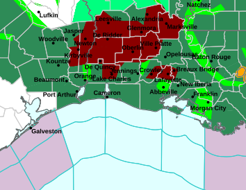
TX/LA

packyderms_wife
Neither here nor there.
Tornado Warning
LAC079-115-112045-
/O.NEW.KLCH.TO.W.0006.240211T2018Z-240211T2045Z/
BULLETIN - EAS ACTIVATION REQUESTED
Tornado Warning
National Weather Service Lake Charles LA
218 PM CST Sun Feb 11 2024
The National Weather Service in Lake Charles has issued a
* Tornado Warning for...
West central Rapides Parish in central Louisiana...
Eastern Vernon Parish in west central Louisiana...
* Until 245 PM CST.
* At 218 PM CST, a severe thunderstorm capable of producing a tornado
was located over Fort Polk, moving northeast at 45 mph.
HAZARD...Tornado.
SOURCE...Radar indicated rotation.
IMPACT...Flying debris will be dangerous to those caught without
shelter. Mobile homes will be damaged or destroyed.
Damage to roofs, windows, and vehicles will occur. Tree
damage is likely.
* This dangerous storm will be near...
Fort Polk and Slagle around 225 PM CST.
Lacamp around 230 PM CST.
Other locations impacted by this tornadic thunderstorm include
Pickering and Simpson.
PRECAUTIONARY/PREPAREDNESS ACTIONS...
TAKE COVER NOW! Move to an interior room on the lowest floor of a
sturdy building. Avoid windows. If you are outdoors, in a mobile
home, or in a vehicle, move to the closest substantial shelter and
protect yourself from flying debris.
&&
LAT...LON 3125 9274 3094 9320 3108 9338 3137 9304
3136 9303 3136 9299 3135 9298 3135 9295
3137 9295 3137 9292 3139 9291 3139 9289
3140 9289
TIME...MOT...LOC 2018Z 228DEG 37KT 3107 9316
TORNADO...RADAR INDICATED
MAX HAIL SIZE...<.75 IN
$$
Stigger/87
SlipperySlope
Veteran Member
There went my peaceful evening.
Countrymouse
Country exile in the city
any current news? Things are supposed to get spicy for us here in GA tomorrow.
any current news? Things are supposed to get spicy for us here in GA tomorrow.
You tell us....
Just sayin'
packyderms_wife
Neither here nor there.
Nothing at the moment and I’m turning in. Keep your head on a swivel!!!
packyderms_wife
Neither here nor there.
RT 8:48 - Ryan Hall y'all xtra
In this video we are talking about more severe weather and snow…
bracketquant
Veteran Member
Over night we got lots of rain how much I have no idea and some time within the last two hours it started to snow (5:00AM).
Was aware that this may happen and that we could end up with 6" to 10" inches of snow dumped on us very quickly, but as of now we only have about an inch on the ground.
Right now the temperature is at 33F or 32F hard to say right now, the snow is a wet snow and it's pulling on limbs it is still snowing as I write this.
packyderms_wife
Neither here nor there.
Calling for 1 to 3 inches of snow here in my part of Central Iowa tomorrow.
packyderms_wife
Neither here nor there.
We've got about 4 inches now. I took pics but everything I try to upload is "too large", no matter what method I try... and I don't have way on the ipad to reduce file size. :P Gone are the days Apple is better at graphics...
Sure you do. Go into your photos folder, click on the photo you want to post, and then click edit. At the bottom of the photo scroll either right or left and change the photo size/ratio. Easy peasy.
packyderms_wife
Neither here nor there.
I’ve been informed that it’s snowing out, kinda sort of. 