
You are using an out of date browser. It may not display this or other websites correctly.
You should upgrade or use an alternative browser.
You should upgrade or use an alternative browser.
WEATHER Severe Weather the Week of February 26th, 2024
- Thread starter packyderms_wife
- Start date

packyderms_wife
Neither here nor there.
LIVE STREAM NWW116
BREAKING: Tornadoes, Widespread Damaging Wind Gusts & Large Hail Expected | Live Weather Report
packyderms_wife
Neither here nor there.
Red flag warnings for Iowa today and tomorrow! 
I just saw that. Warm and windy conditions noted.Red flag warnings for Iowa today and tomorrow!
Are things really that dry out your way?
adgal
Veteran Member
We’re under red flag warnings here in NW Illinois too. I’m thinking it’s not so much that things are so dry - it’s all the dead brush that should be under snow.I just saw that. Warm and windy conditions noted.
Are things really that dry out your way?
packyderms_wife
Neither here nor there.
Umm, yeah, really bad, sigh. The wind tomorrow won’t help much.I just saw that. Warm and windy conditions noted.
Are things really that dry out your way?
Severe to extreme drought conditions. Cue in the dust bowl.
packyderms_wife
Neither here nor there.

Most of the Front Range and a good chunk of the midwest is under Red Flag warnings today --> means there's a very high risk for wild fires... stay safe everyone!
Last edited:
packyderms_wife
Neither here nor there.
RT 10:56. - Ryan Hall y'all xtra
A Dangerous Storm Is Forming…
Yes, we're now in year 9 of a forecasted 7-year drought.I just saw that. Warm and windy conditions noted.
Are things really that dry out your way?
packyderms_wife
Neither here nor there.
Buckle up, it's about to get spicy out there this afternoon! High here in central Iowa will be 60F with a low tonight of 13F!!!
View: https://www.youtube.com/watch?v=Wf5jA9HF8iw
RT 9:35 - Max Velocity
In this weather forecast, we are breaking down A LARGE STORM that will bring a significant severe weather event, winter storm, and record-breaking high temperatures to the Midwest, Ohio Valley, Central/Northern Plains, and Northeast! This storm will bring a few tornadoes, very large hail, and damaging winds TONIGHT to the Midwest and Ohio Valley. This winter heatwave will impact areas like the Southern Plains, Mississippi Valley, Midwest, and Ohio Valley. Find the latest details of the weather across the United States in our latest weather forecast.
Quite a few fires going to the south.
Lotsa wind, no rain for several days.

 www.fireweatheravalanche.org
Lotsa wind, no rain for several days.
FWAC Wildfire Map - Current Wildfires, Forest Fires, and Lightning Strikes near you | Fire, Weather & Avalanche Center
Interactive real-time wildfire map for the United States, including California, Oregon, Washington, Idaho, Arizona, and others. See current wildfires and wildfire perimeters near you using the Fire, Weather & Avalanche Center Wildfire Map.
Last edited:
packyderms_wife
Neither here nor there.
Quite a few fires going to the south.
Lotsa wind, no rain for several days.
FWAC Wildfire Map - Current Wildfires, Forest Fires, and Lightning Strikes near you | Fire, Weather & Avalanche Center
Interactive real-time wildfire map for the United States, including California, Oregon, Washington, Idaho, Arizona, and others. See current wildfires and wildfire perimeters near you using the Fire, Weather & Avalanche Center Wildfire Map.
Thanks for the link, there appears to be quite a few fires in Minnesota right now.
Thanks for the link, there appears to be quite a few fires in Minnesota right now.
Tweak the layers settings to weed out lightning strikes and such.
Toggle "older than 12 hours".
Click on individual fires to see age and status.
packyderms_wife
Neither here nor there.
Tweak the layers settings to weed out lightning strikes and such.
Toggle "older than 12 hours".
Click on individual fires to see age and status.
Is that what those maroon blobs are, lightening strikes?
packyderms_wife
Neither here nor there.
Thanks MW that app is way cool, and if things keep going the way they are now, weather wise, they will need to be adding a blowing dust layer to that app. It truly does look like we're headed into another dust bowl.
psychgirl
Has No Life - Lives on TB
We’re getting it tonightBuckle up, it's about to get spicy out there this afternoon! High here in central Iowa will be 60F with a low tonight of 13F!!!
View: https://www.youtube.com/watch?v=Wf5jA9HF8iw
RT 9:35 - Max Velocity
In this weather forecast, we are breaking down A LARGE STORM that will bring a significant severe weather event, winter storm, and record-breaking high temperatures to the Midwest, Ohio Valley, Central/Northern Plains, and Northeast! This storm will bring a few tornadoes, very large hail, and damaging winds TONIGHT to the Midwest and Ohio Valley. This winter heatwave will impact areas like the Southern Plains, Mississippi Valley, Midwest, and Ohio Valley. Find the latest details of the weather across the United States in our latest weather forecast.
It’s too warm and humid for this time of year here.
packyderms_wife
Neither here nor there.
We’re getting it tonight
It’s too warm and humid for this time of year here.
Calling for an inch of snow here, in central Iowa, overnight.
We're seeing the drastic drop in temps, going from 67 to 20, tomorrow. I'm hoping the beehive cover I made last month will keep them from dying due to the fast drop in temps. They've been doing well, so far.
Summerthyme.
Summerthyme.
Last edited:
Thanks MW that app is way cool, and if things keep going the way they are now, weather wise, they will need to be adding a blowing dust layer to that app. It truly does look like we're headed into another dust bowl.
You can get some dust info from the GOES16 sat loops.
Pick an area and click, then scroll down for RGB/dust filter.
It's a color based image, makes it hard for me.

GOES Imagery Viewer - NOAA / NESDIS / STAR
Near real-time publication of GOES-East and GOES-West images from NOAA/NESDIS/STAR
(N MN) Yeah, it's 40 here right now, but wind kicking up from the north and temps dropping all day down to zero (or below) tonight. I doubt I'll see much snow here, but further north and on the south shore of L. Superior in WI (lake effect) gonna be ugly.
Haha...and then...back up into the 50's again by Friday!
Haha...and then...back up into the 50's again by Friday!


WanderLore
Veteran Member
SC MI it is over 70! They are predicting very bad storms and possible tornadoes, along with 2" hail.
It might, or it might now, depending on developments. Then a drastic temp drop and snow. Bizarre.
It might, or it might now, depending on developments. Then a drastic temp drop and snow. Bizarre.
packyderms_wife
Neither here nor there.
SC MI it is over 70! They are predicting very bad storms and possible tornadoes, along with 2" hail.
It might, or it might now, depending on developments. Then a drastic temp drop and snow. Bizarre.
The interesting thing about this weather pattern is the local news here in central Iowa keeps comparing it to the 1930's as the last time we had an event like this specifically 1936.
1936 was probably one of the worst years for the dust bowl, and was technically the last year of the dust bowl. Right now, as Anna pointed out, here in Iowa we 're in year nine of what was supposed to be a three to six year drought.


packyderms_wife
Neither here nor there.
I see the weather chasers are already posting their chase times for today... most are in the upper midwest.
View: https://www.youtube.com/watch?v=DQgiTFUZP2I
RT 3:08 - FOX Weather
RT 3:08 - FOX Weather
Rare February Storms Target The Midwest As Golf-Ball Sized Hail Could Pound 5 States
packyderms_wife
Neither here nor there.
His live feed/chase will start around 5pm CST this afternoon. Just watched a FOX Weather blurb, a year ago today we had the same set up for severe weather, in the same area!
I would not completely rule out an SPC upgrade to "Moderate" in either or both of the current "Enhanced" areas later this afternoon or overnight.
View: https://twitter.com/ConvChronicles/status/1762527072629535176
View: https://twitter.com/ConvChronicles/status/1762527072629535176
Last edited:
adgal
Veteran Member
We're at 71 in NW Illinois right now - by midnight, we are supposed to be at 34 with snow showers. And by 9 a.m. we're supposed to be at 17. It's crazy. The showers are supposed to start at about 6 this evening. We are not supposed to get severe weather where we are - but I'm going to keep an eye out anyway.
packyderms_wife
Neither here nor there.
LIVE STREAM - NWW116
BREAKING: EF2+ Tornadoes, Enormous Hail & Significant Wind Damage Possible TODAY!
Right now, in NW Iowa temp is 32 degrees but it "feels like" 7 degrees. Winds are 23 to 30 mph with gusts to 45 mph out of the NW. High was 46 degrees earlier this morning and low is forecast to be 7 degrees which means windchill is going to take us well below zero. The way the wind is blasting I'd say it steady above 30 mph. With the wind and forecast snow, we're looking at whiteouts and drifts. Time to hibernate again (a blessing of being retired).
Tornado Watch being issued soon. This is the heads up to the local weather offices.

Mesoscale Discussion 0163
NWS Storm Prediction Center Norman OK
0250 PM CST Tue Feb 27 2024
Areas affected...Northern IL and far northwest IN
Concerning...Severe potential...Tornado Watch likely
Valid 272050Z - 272245Z
Probability of Watch Issuance...80 percent
SUMMARY...A few supercells are expected to develop over parts of
northwest Illinois and then spread east-northeast across northern
Illinois into far northwest Indiana through early evening. Very
large hail to around baseball size will be the primary initial
threat. A conditional strong tornado scenario may develop later over
northeast Illinois into far northwest Indiana.
DISCUSSION...20Z subjective surface analysis placed a 990-mb cyclone
near the Quad Cities along a pronounced cold front sweeping
southeast across the Upper MS to Lower MO Valleys. A bent-back plume
of relatively richer surface dew points from the mid to upper 50s
lies immediately ahead of this wave, along the northwest periphery
of the broader warm-moist sector across the OH Valley and lower
Midwest. Within the exit region of an intense mid-level jet shifting
east from the southern Great Plains to the Lower OH Valley,
continued ascent should yield sufficient weakening of MLCIN during
the 22-23Z time frame. Initial storm development is most likely in
the immediate vicinity of the surface low.
The environment will be favorable for discrete supercells forming
despite initially modest low-level shear. Amid very steep mid-level
lapse rates, large to very large hail production is expected, with
peak intensity around 2 to 3.5 inches possible. The primary
uncertainty is with how convection evolves downstream given the
relatively narrow warm/moist sector where storms develop. There
should be a tendency for convection to spread into a drier boundary
layer towards the WI border. It is plausible, within a scenario
highlighted by various 12Z MPAS members and occasionally by later
WoFS/RRFS/HRRR runs, that a longer-tracked supercell or two may
develop into the broader warm-moist sector across northeast IL into
far northwest IN. Low-level shear within this region will be
increasing towards and after dusk, which will conditionally support
potential for a strong tornado into the EF2-EF3 range (peak
estimated gusts around 120 to 150 mph).
..Grams/Hart.. 02/27/2024
...Please see www.spc.noaa.gov for graphic product...
Storm Prediction Center Mesoscale Discussion 163
Severe weather, tornado, thunderstorm, fire weather, storm report, tornado watch, severe thunderstorm watch, mesoscale discussion, convective outlook products from the Storm Prediction Center.
www.spc.noaa.gov
packyderms_wife
Neither here nor there.
WILD FIRE Evacuations for OK and TX
OKC139-272330-
BULLETIN - EAS ACTIVATION REQUESTED
EVACUATION IMMEDIATE
TEXAS COUNTY EMERGENCY MANAGEMENT AGENCY GUYMON OKLAHOMA
RELAYED BY NATIONAL WEATHER SERVICE AMARILLO TX
230 PM CST TUE FEB 27 2024
THE FOLLOWING MESSAGE IS TRANSMITTED AT THE REQUEST OF THE TEXAS
COUNTY EMERGENCY MANAGEMENT AGENCY GUYMON OKLAHOMA.
A MANDATORY EVACUATION ORDER HAS BEEN PUT IN PLACE FOR PERSONS IN
THE LOCATION FROM HIGHWAY 136 TO MILE 34 AND THREE MILES SOUTH OF
THIS. THE DESIGNATED SHELTER SET UP IS THE TEXAS COUNTY EMERGENCY
MANAGEMENT OFFICE AT 2906 TUMBLEWEED DRIVE IN GUYMON OKLAHOMA.
$$
TXC341-272230-
BULLETIN - EAS ACTIVATION REQUESTED
EVACUATION IMMEDIATE
TEXAS EMERGENCY MANAGEMENT AGENCY AMARILLO TEXAS
RELAYED BY NATIONAL WEATHER SERVICE AMARILLO TX
129 PM CST TUE FEB 27 2024
...MANDATORY EVACUTION FOR DOUBLE DIAMOND IN MOORE COUNTY...
THE FOLLOWING MESSAGE IS TRANSMITTED AT THE REQUEST OF THE MOORE
COUNTY EMERGENCY MANAGEMENT AGENCY DUMAS TEXAS.
A MANDATORY EVACUATION ORDER HAS BEEN PUT IN PLACE FOR DOUBLE
DIAMOND DUE TO ONGOING WILDFIRE. A SHELTER HAS BEEN DESIGNATED AT
THE CELEBRATION CHURCH IN FRITCH. ADDRESS IS 811 EAST BROADWAY
FRITCH TEXAS.
$$
packyderms_wife
Neither here nor there.
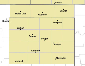
OK/TX Wild Fire Evacuation Map
packyderms_wife
Neither here nor there.
LIVE STREAM - ABC 7 Amarillo
SMOKEHOUSE CREEK FIRE
Live picture of 100,000 acre Smokehouse Creek Fire from Canadian, Texas on February 27, 2024
packyderms_wife
Neither here nor there.
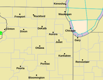
Tornado Watch box just went up for northern Illinois...
psychgirl
Has No Life - Lives on TB
Been on our Indy area news all day. I think this one is gonna get ugly.Tornado Watch being issued soon. This is the heads up to the local weather offices.
View attachment 462707
Mesoscale Discussion 0163
NWS Storm Prediction Center Norman OK
0250 PM CST Tue Feb 27 2024
Areas affected...Northern IL and far northwest IN
Concerning...Severe potential...Tornado Watch likely
Valid 272050Z - 272245Z
Probability of Watch Issuance...80 percent
SUMMARY...A few supercells are expected to develop over parts of
northwest Illinois and then spread east-northeast across northern
Illinois into far northwest Indiana through early evening. Very
large hail to around baseball size will be the primary initial
threat. A conditional strong tornado scenario may develop later over
northeast Illinois into far northwest Indiana.
DISCUSSION...20Z subjective surface analysis placed a 990-mb cyclone
near the Quad Cities along a pronounced cold front sweeping
southeast across the Upper MS to Lower MO Valleys. A bent-back plume
of relatively richer surface dew points from the mid to upper 50s
lies immediately ahead of this wave, along the northwest periphery
of the broader warm-moist sector across the OH Valley and lower
Midwest. Within the exit region of an intense mid-level jet shifting
east from the southern Great Plains to the Lower OH Valley,
continued ascent should yield sufficient weakening of MLCIN during
the 22-23Z time frame. Initial storm development is most likely in
the immediate vicinity of the surface low.
The environment will be favorable for discrete supercells forming
despite initially modest low-level shear. Amid very steep mid-level
lapse rates, large to very large hail production is expected, with
peak intensity around 2 to 3.5 inches possible. The primary
uncertainty is with how convection evolves downstream given the
relatively narrow warm/moist sector where storms develop. There
should be a tendency for convection to spread into a drier boundary
layer towards the WI border. It is plausible, within a scenario
highlighted by various 12Z MPAS members and occasionally by later
WoFS/RRFS/HRRR runs, that a longer-tracked supercell or two may
develop into the broader warm-moist sector across northeast IL into
far northwest IN. Low-level shear within this region will be
increasing towards and after dusk, which will conditionally support
potential for a strong tornado into the EF2-EF3 range (peak
estimated gusts around 120 to 150 mph).
..Grams/Hart.. 02/27/2024
...Please see www.spc.noaa.gov for graphic product...
Storm Prediction Center Mesoscale Discussion 163
Severe weather, tornado, thunderstorm, fire weather, storm report, tornado watch, severe thunderstorm watch, mesoscale discussion, convective outlook products from the Storm Prediction Center.www.spc.noaa.gov