WEATHER Severe Weather the Week of February 26th, 2024

packyderms_wife

Neither here nor there.
Illinois


Severe Weather Statement
National Weather Service Quad Cities IA/IL
551 PM CST Tue Feb 27 2024

ILC073-280015-
/O.CON.KDVN.TO.W.0002.000000T0000Z-240228T0015Z/
Henry IL-
551 PM CST Tue Feb 27 2024

...A TORNADO WARNING REMAINS IN EFFECT UNTIL 615 PM CST FOR EAST
CENTRAL HENRY COUNTY...

At 551 PM CST, a severe thunderstorm capable of producing a tornado
was located near Atkinson, or 9 miles northeast of Cambridge, moving
east at 30 mph.

HAZARD...Tornado and golf ball size hail.

SOURCE...Radar indicated rotation.

IMPACT...Flying debris will be dangerous to those caught without
shelter. Mobile homes will be damaged or destroyed. Damage
to roofs, windows, and vehicles will occur. Tree damage is
likely.

This dangerous storm will be near...
Atkinson and Annawan around 555 PM CST.

This includes Interstate 80 in Illinois between mile markers 22 and
35.

PRECAUTIONARY/PREPAREDNESS ACTIONS...

TAKE COVER NOW! Move to a basement or an interior room on the lowest
floor of a sturdy building. Avoid windows. If you are outdoors, in a
mobile home, or in a vehicle, move to the closest substantial shelter
and protect yourself from flying debris.

If a tornado or other severe weather is spotted, report it to the
National Weather Service or your local nearest law enforcement agency
who will send your report. This act may save lives of others in the
path of dangerous weather.

&&

LAT...LON 4136 9010 4140 9013 4145 9011 4151 8986
4135 8986
TIME...MOT...LOC 2351Z 270DEG 25KT 4137 9004

TORNADO...RADAR INDICATED
MAX HAIL SIZE...1.75 IN

$$

Gibbs
 

Millwright

Knuckle Dragger
_______________
Satellite IR of fires in Tx & Ok.

20240582351_GOES16-ABI-sp-FireTemperature-2400x2400.jpg
 

Millwright

Knuckle Dragger
_______________
That fire is a monster.

Almost 300,000 acres, 0% contained.

It's stretched out for 150miles, from what I can tell.

Smokehouse Creek Fire​

Follow this fire
Fire Status
ACTIVE
Size:
250,000 acres
Initial Location:
1.9 miles NNE of Stinnett, TX
Fuels:
Tall Grass (2.5 feet), Tall Grass (2.5 feet)


Last edited:

packyderms_wife

Neither here nor there.
That fire is a monster.

Almost 300,000 acres, 0% contained.

It's stretched out for 150miles, from what I can tell.

Smokehouse Creek Fire​

Follow this fire
Fire Status
ACTIVE
Size:
250,000 acres
Initial Location:
1.9 miles NNE of Stinnett, TX
Fuels:
Tall Grass (2.5 feet), Tall Grass (2.5 feet)


I


I posted a video up three, I seriously considered starting a thread. I’m on my phone.
 

Red Baron

Paleo-Conservative
_______________
FWIW - We were married in Wayne, IL.
------
BULLETIN - EAS ACTIVATION REQUESTED
TORNADO WARNING
NATIONAL WEATHER SERVICE CHICAGO/ROMEOVILLE
711 PM CST TUE FEB 27 2024

THE NATIONAL WEATHER SERVICE IN CHICAGO HAS ISSUED A

* TORNADO WARNING FOR...
SOUTHEASTERN KANE COUNTY IN NORTHEASTERN ILLINOIS...

* UNTIL 730 PM CST.

* AT 711 PM CST, A TORNADO PRODUCING STORM WAS LOCATED NEAR NORTH
AURORA, OR NEAR BATAVIA, MOVING NORTHEAST AT 45 MPH.


HAZARD...DAMAGING TORNADO.

SOURCE...RADAR CONFIRMED TORNADO.

IMPACT...FLYING DEBRIS WILL BE DANGEROUS TO THOSE CAUGHT WITHOUT
SHELTER. MOBILE HOMES WILL BE DAMAGED OR DESTROYED.
DAMAGE TO ROOFS, WINDOWS, AND VEHICLES WILL OCCUR. TREE
DAMAGE IS LIKELY.

* THIS TORNADIC STORM WILL BE NEAR...
ST. CHARLES, WEST CHICAGO, BATAVIA, GENEVA, AND NORTH AURORA
AROUND 715 PM CST.
WAYNE AROUND 720 PM CST.

PRECAUTIONARY/PREPAREDNESS ACTIONS...

TO REPEAT, A TORNADO IS ON THE GROUND. TAKE COVER NOW! MOVE TO A
BASEMENT OR AN INTERIOR ROOM ON THE LOWEST FLOOR OF A STURDY
BUILDING. AVOID WINDOWS. IF YOU ARE OUTDOORS, IN A MOBILE HOME, OR IN
A VEHICLE, MOVE TO THE CLOSEST SUBSTANTIAL SHELTER AND PROTECT
YOURSELF FROM FLYING DEBRIS.
 
Last edited:

Red Baron

Paleo-Conservative
_______________
SEVERE WEATHER STATEMENT
NATIONAL WEATHER SERVICE CHICAGO/ROMEOVILLE
740 PM CST TUE FEB 27 2024

ILC031-043-097-280230-
/O.CON.KLOT.TO.W.0010.000000T0000Z-240228T0230Z/
LAKE IL-DUPAGE IL-COOK IL-
740 PM CST TUE FEB 27 2024

...A TORNADO WARNING REMAINS IN EFFECT UNTIL 830 PM CST FOR
SOUTHEASTERN LAKE...NORTHEASTERN DUPAGE AND NORTHWESTERN COOK
COUNTIES...


AT 739 PM CST, TORNADO PRODUCING STORMS WERE LOCATED ALONG A LINE
EXTENDING FROM NEAR HAWTHORN WOODS TO GLENDALE HEIGHTS, MOVING EAST
AT 35 MPH.

HAZARD...DAMAGING TORNADO.

SOURCE...WEATHER SPOTTERS CONFIRMED TORNADO NEAR IVERNESS AND
PALATINE. ADDITIONAL TORNADOES ARE POSSIBLE WITHIN THE
WARNING!


IMPACT...FLYING DEBRIS WILL BE DANGEROUS TO THOSE CAUGHT WITHOUT
SHELTER. MOBILE HOMES WILL BE DAMAGED OR DESTROYED. DAMAGE
TO ROOFS, WINDOWS, AND VEHICLES WILL OCCUR. TREE DAMAGE IS
LIKELY.

THESE TORNADIC STORMS WILL BE NEAR...
CHICAGO, ARLINGTON HEIGHTS, SCHAUMBURG, PALATINE, DES PLAINES,
MOUNT PROSPECT, BUFFALO GROVE, WHEELING, ADDISON, AND ELK GROVE
VILLAGE AROUND 745 PM CST.
GLENVIEW, OHARE AIRPORT, PARK RIDGE, NORTHBROOK, LAKE FOREST,
DEERFIELD, SCHILLER PARK, ROSEMONT, GREEN OAKS, AND BANNOCKBURN
AROUND 750 PM CST.

OTHER LOCATIONS IN THE PATH OF THESE TORNADIC STORMS INCLUDE NORTH
CHICAGO, NILES, HIGHLAND PARK, MORTON GROVE, LAKE BLUFF, HIGHWOOD,
SKOKIE, WILMETTE, LINCOLNWOOD, WINNETKA, GLENCOE, NORTHFIELD,
EVANSTON AND KENILWORTH.

OEMC ZONES...TORNADO WARNING. 1 AND 2.

PRECAUTIONARY/PREPAREDNESS ACTIONS...

TO REPEAT, A TORNADO IS ON THE GROUND. TAKE COVER NOW! MOVE TO A
BASEMENT OR AN INTERIOR ROOM ON THE LOWEST FLOOR OF A STURDY
BUILDING. AVOID WINDOWS. IF YOU ARE OUTDOORS, IN A MOBILE HOME, OR IN
A VEHICLE, MOVE TO THE CLOSEST SUBSTANTIAL SHELTER AND PROTECT
YOURSELF FROM FLYING DEBRIS.
 

Red Baron

Paleo-Conservative
_______________
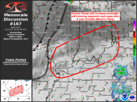
Round II is on deck.

Overnight is when a NOAA weather radio is very useful.

1709088993138.png

Mesoscale Discussion 0167
NWS Storm Prediction Center Norman OK
0746 PM CST Tue Feb 27 2024

Areas affected...southern Illinois and Indiana into portions of
northern Kentucky and southwest Ohio

Concerning...Severe potential...Watch likely

Valid 280146Z - 280345Z

Probability of Watch Issuance...95 percent

SUMMARY...The severe risk is expected to increase this evening and
overnight
upper-level ascent and a fast-moving cold front intersect
with the retreating dryline. Bowing segments and supercells will be
capable of all severe hazards as they spread east along the OH
Valley. A new Tornado Watch will likely be needed in the next 1-2
hours.


DISCUSSION...Over the last hour, surface obs near STL showed the
dryline retreating westward with a surge in dewpoints to the low 60s
F. Evening water-vapor and IR imagery showed large-scale ascent
beginning to impinge on the warm sector across portions of the mid
MS and lower OH Valleys. Weak convection in the well-mixed warm
sector to the west has steadily deepened, and should move into more
robust surface moisture this evening. Additional convection also
appears likely to develop along the cold front surging southeastward
across eastern MO later tonight.

Low 60s F surface dewpoints and ~1000 J/kg of MLCAPE will support
strong updrafts within the warm sector. Very favorable deep-layer
shear (50-60 kt) will support a mix of supercells and short bowing
segments. Damaging gusts and hail appear likely, given the strong
vertical shear and favorable buoyancy. Rapidly increasing low-level
shear (evident on area VADs) may support a risk for tornadoes,
especially with more sustained supercells. A significant tornado
also cannot be ruled out
, given very large effective helicity of
400-600 m2/s2 and a 50-60 kt 850 mb jet.

Confidence remains low on the exact timing of convective initiation,
given that some convective inhibition remains. As ascent begins to
deepen, most hi-res guidance, and extrapolation of weaker convection
farther west, suggests new storms should develop in the next 1-2
hours and quickly become severe. With all severe hazards possible, a
new Tornado Watch is likely needed in the next couple of hours for
parts of southern IL/ IN into northern KY and southwestern OH.

..Lyons/Edwards.. 02/28/2024

...Please see www.spc.noaa.gov for graphic product...
 

marsh

On TB every waking moment

Up to 12 feet of snow heading to California mountains: What to expect​

Winter storm watches were issued for California, Oregon and Washington.

ByMax Golembo
February 27, 2024, 12:55 PM

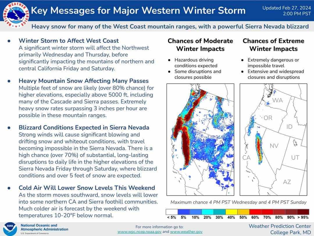
Up to 12 feet of snow is heading to California's Sierra Nevada mountains as a new winter storm bears down on the West Coast.

Winter storm watches have been issued for California, Oregon and Washington.

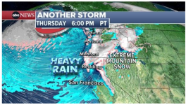
1709108644338.png

The storm will begin in the Pacific Northwest on Wednesday and will reach California by Thursday, bringing rain to the San Francisco area and snow to the mountains.

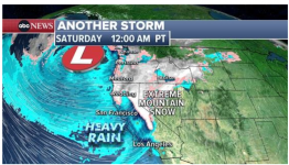
The rain will spread into Southern California from Friday night into Saturday.

The heaviest snow -- 4 to 12 feet -- will hit the Sierra Nevada mountains Friday to Sunday.

1709108698550.png
Snowfall rates could reach 1 to 3 inches per hour in the mountains. Strong winds are also forecast to cause blowing and drifting snow, which will reduce visibility and make driving in the mountains extremely dangerous.

The winter storm will spread into the Rockies early next week.
 

marsh

On TB every waking moment

Season’s Biggest Storm Set to Dump Up To 12-Feet of Snow on California​

WeatherBrains | February 27, 2024 | Post Tag for Weather Weather
Share this article​

twitter icon fb icon pinterest icon pinterest icon pinterest icon pinterest icon

423903758_3708791189366899_5261602572712965092_n.jpg
Credit: NWS Sacramento
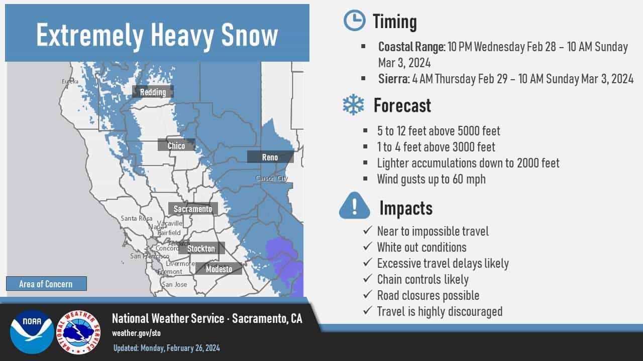
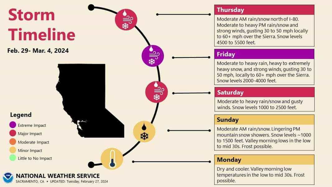
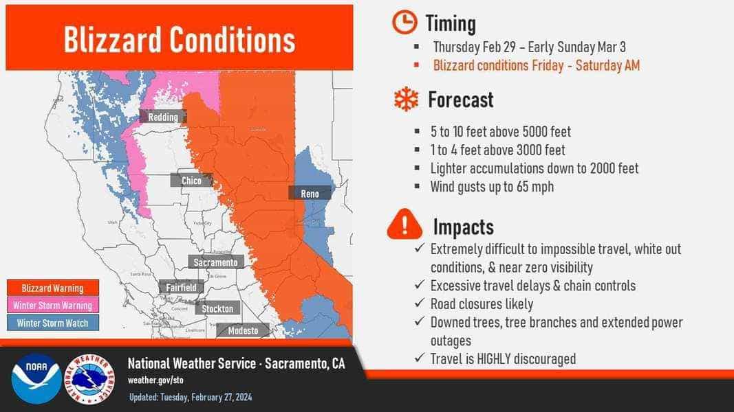
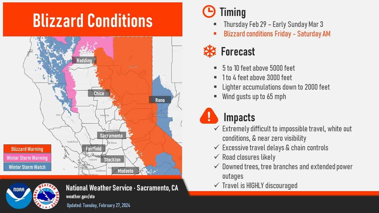
The season’s biggest storm is set to pummel California this week, potentially dumping up to 12 FEET of snow at elevations above 5,000 feet in the Sierra Nevada.

The National Weather Service office in Reno issued a stark warning: “Even by Sierra standards, this is shaping up to be a highly impactful, major winter storm. If these snow totals hold, this will easily be the biggest storm of the season.”

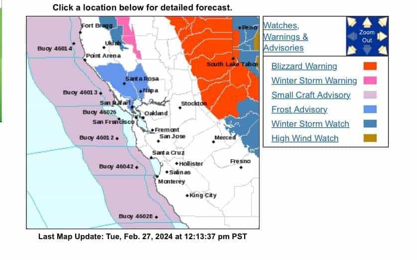
A blizzard warning has been issued for the Greater Lake Tahoe Area, beginning at 10 a.m. Thursday through 10 a.m. Sunday.


…BLIZZARD WARNING IN EFFECT FROM 10 AM THURSDAY TO 10 AM PST SUNDAY…
* WHAT…Blizzard conditions likely, particularly from Friday evening through Saturday morning. Snow accumulations between 2 and 4 feet for Lake Tahoe communities, with 4 to 8 feet above 7000 feet. Winds gusting to 60 mph in lower elevations and above 100 mph over Sierra ridges.
* WHERE…Greater Lake Tahoe Area.
* WHEN…From 10 AM Thursday to 10 AM PST Sunday.
* IMPACTS…Whiteout conditions with near zero visibility at times due to blowing snow. The strong winds and weight of snow on tree limbs may down power lines and could cause sporadic power outages. Whiteout conditions are expected and will make travel treacherous and potentially life-threatening.

PRECAUTIONARY/PREPAREDNESS ACTIONS…
A Blizzard Warning means severe winter weather conditions are expected or occurring. Falling and blowing snow with strong winds are likely. This will lead to whiteout conditions, making travel extremely dangerous. Do not travel. If you must travel, have a winter survival kit with you. If you get stranded, stay in your vehicle.

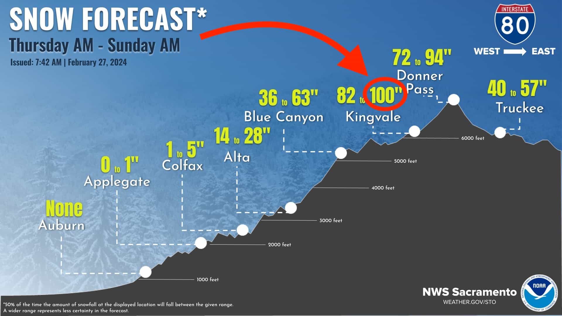
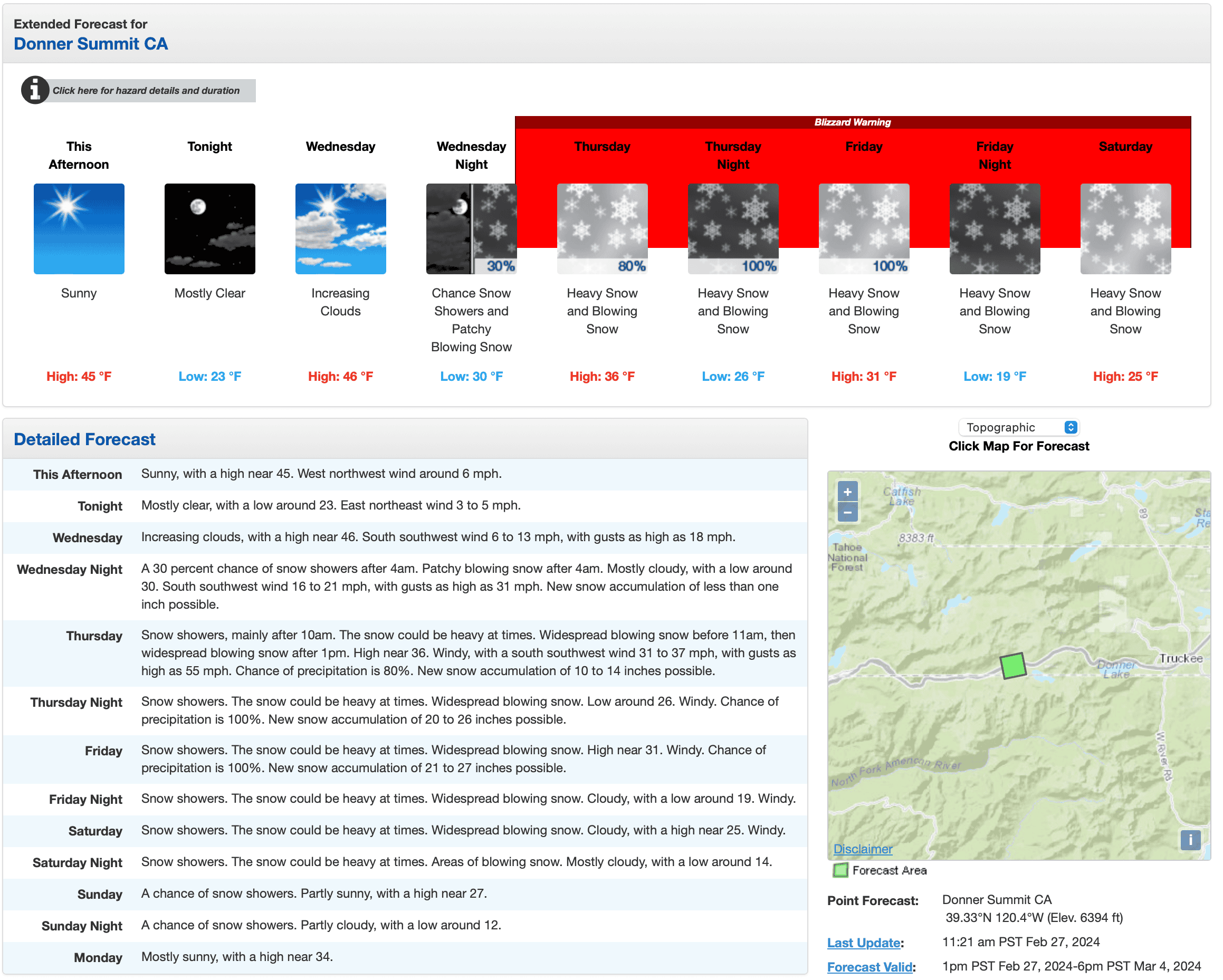
Donner Summit could see up to 100″ of snow. Communities along Highway 395 in Mono County, including Mammoth Lakes and June Lakes, may see between 1 to 3 feet of snow accumulation, while the Tahoe Basin faces the potential of up to 4 feet of snow, with more than 3 feet expected in South Lake Tahoe, Incline Village, and Tahoe City.

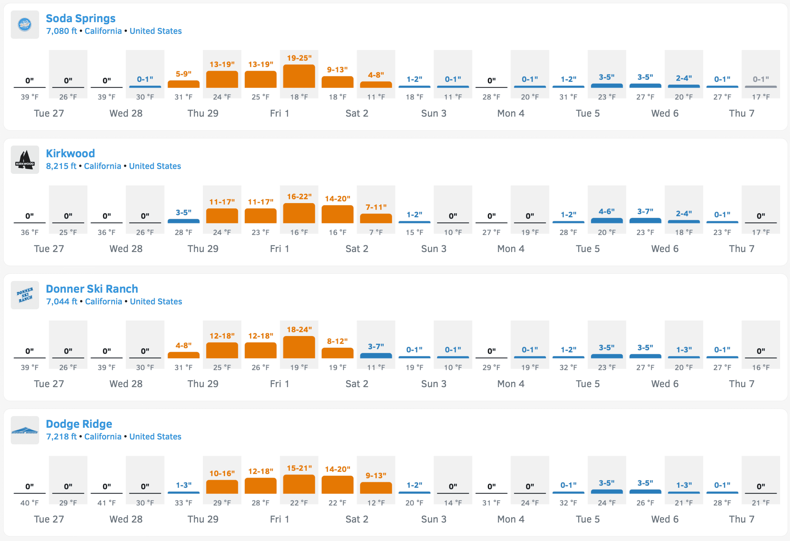
California’s ski resorts, which have had a below-average start to the season, could see multiple feet of snow, setting them up nicely for the rest of the season. According to OpenSnow, below are some forecasted snowfall totals over the next 10 days:
  • Soda Springs – 92″
  • Bear Valley – 91″
  • Dodge Ridge – 89″
  • China Peak – 87″
  • Boreal – 83″
  • Sierra-at-Tahoe – 82″
  • Sugar Bowl – 77″
  • Palisades Tahoe – 74″
  • Kirkwood – 68″
  • Mammoth – 54″
SCR-20240227-nikt.png
Forecasted snow totals. Credit: OpenSnow

With winds expected to surpass 120 mph along ridge tops, blizzard conditions with near-zero visibility are likely, making travel dangerous. Forecasters have advised residents to use the calm weather preceding the storm to prepare adequately, warning that travel from early Thursday through Sunday morning may be nearly impossible.

In Southern California, the storm could bring a slight chance of rain to Los Angeles County on Friday, intensifying on Saturday and possibly lingering into Sunday. In the mountains, rainfall estimates range from 1 to 3 inches, with potential snowfall below 3,000 feet.

Infographics

428310734_734007841850041_8398337219430693189_n.jpg
5-12 feet expected above 5,000-feet. Credit: NWS Sacramento

SCR-20240227-neta.png
Extended forecast for Donner Summit. Credit: NOAA

SCR-20240227-neii.jpg
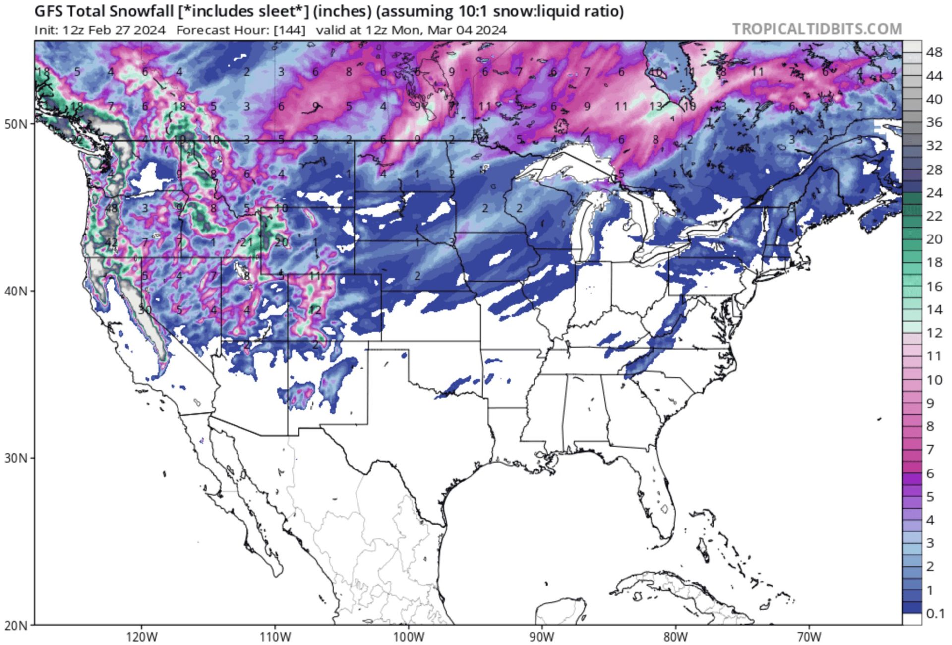
GFS model for today through Monday. Credit: Tropical Tidbits

GEM model for snowfall from today through Monday. Credit: Tropical Tidbits


Snow forecast for I-80. Credit: NWS Sacramento

429962780_801009492055385_7819266245068497272_n.jpg
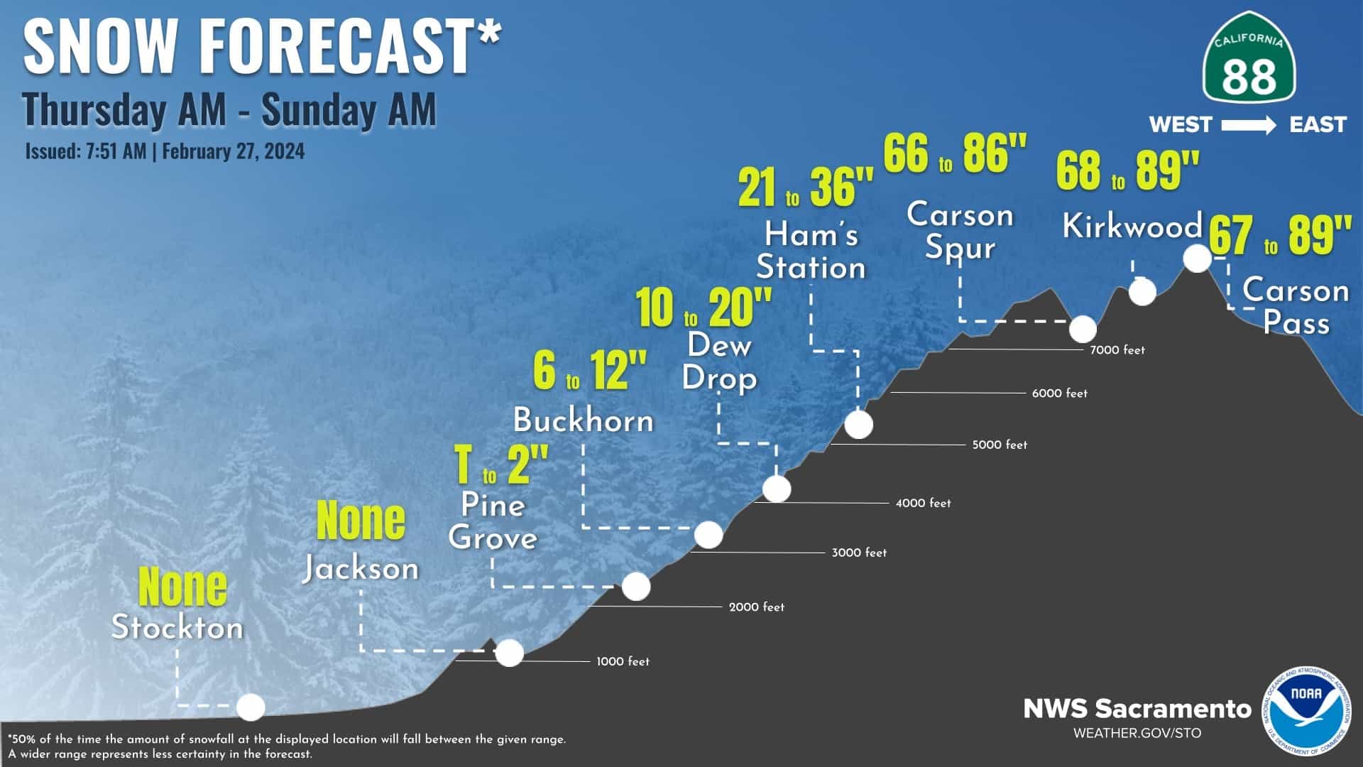
Snow forecast for State HWY 88. Credit: NWS Sacramento

429839039_801009645388703_7149939472646392258_n.jpg
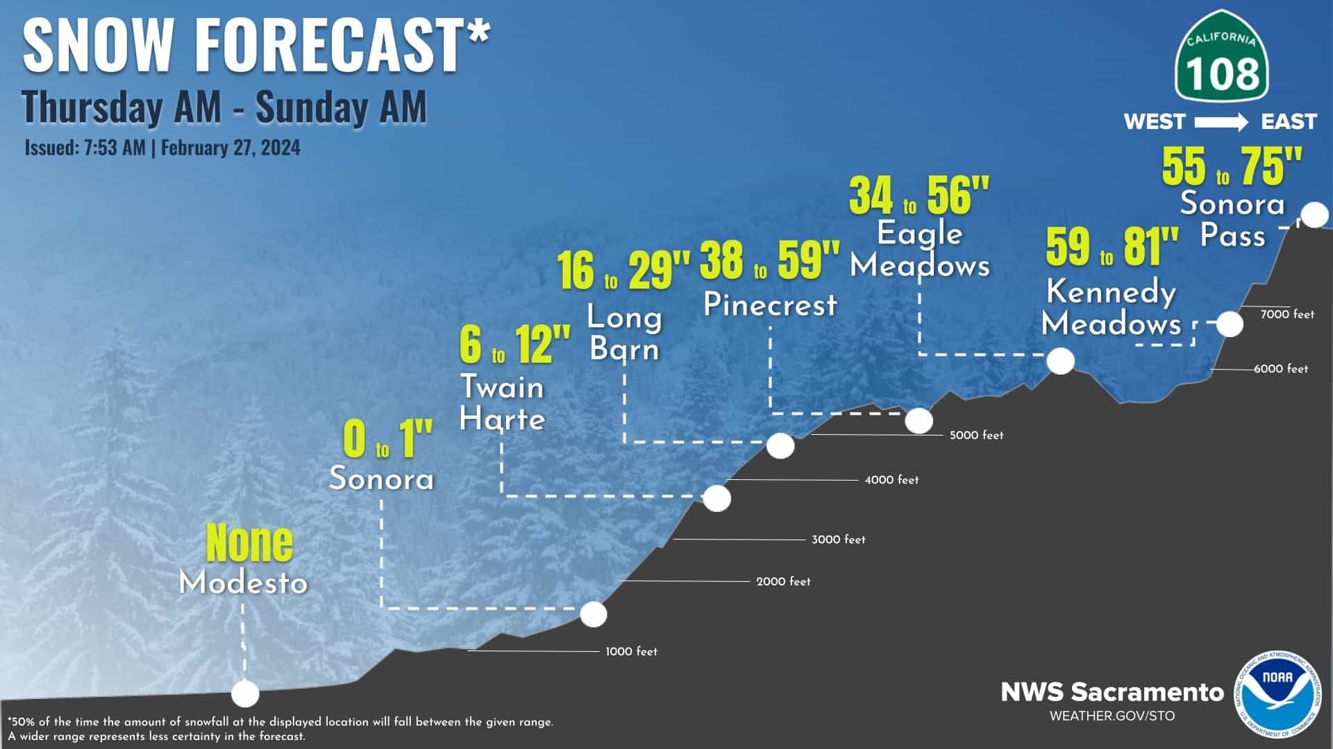
Snow forecast for State HWY 108. Credit: NWS Sacramento

430091208_801009555388712_5434672549207339026_n.jpg
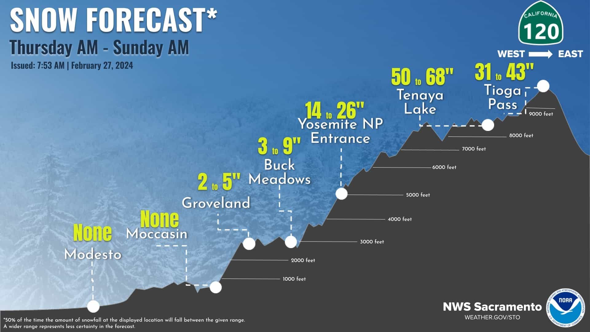
Snow forecast for State HWY 120. Credit: NWS Sacramento

429818393_801009302055404_3981155963689848113_n.jpg
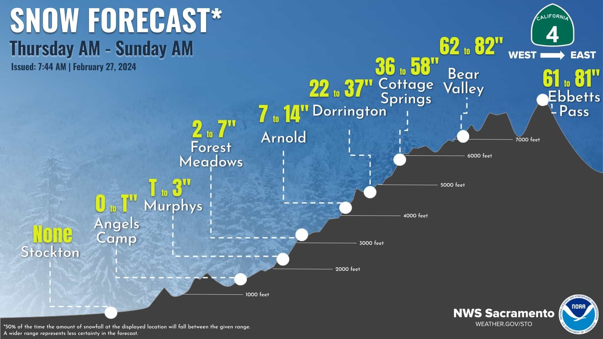
Snow forecast for State HWY 4. Credit: NWS Sacramento

429974048_801009635388704_5957925303245786485_n.jpg
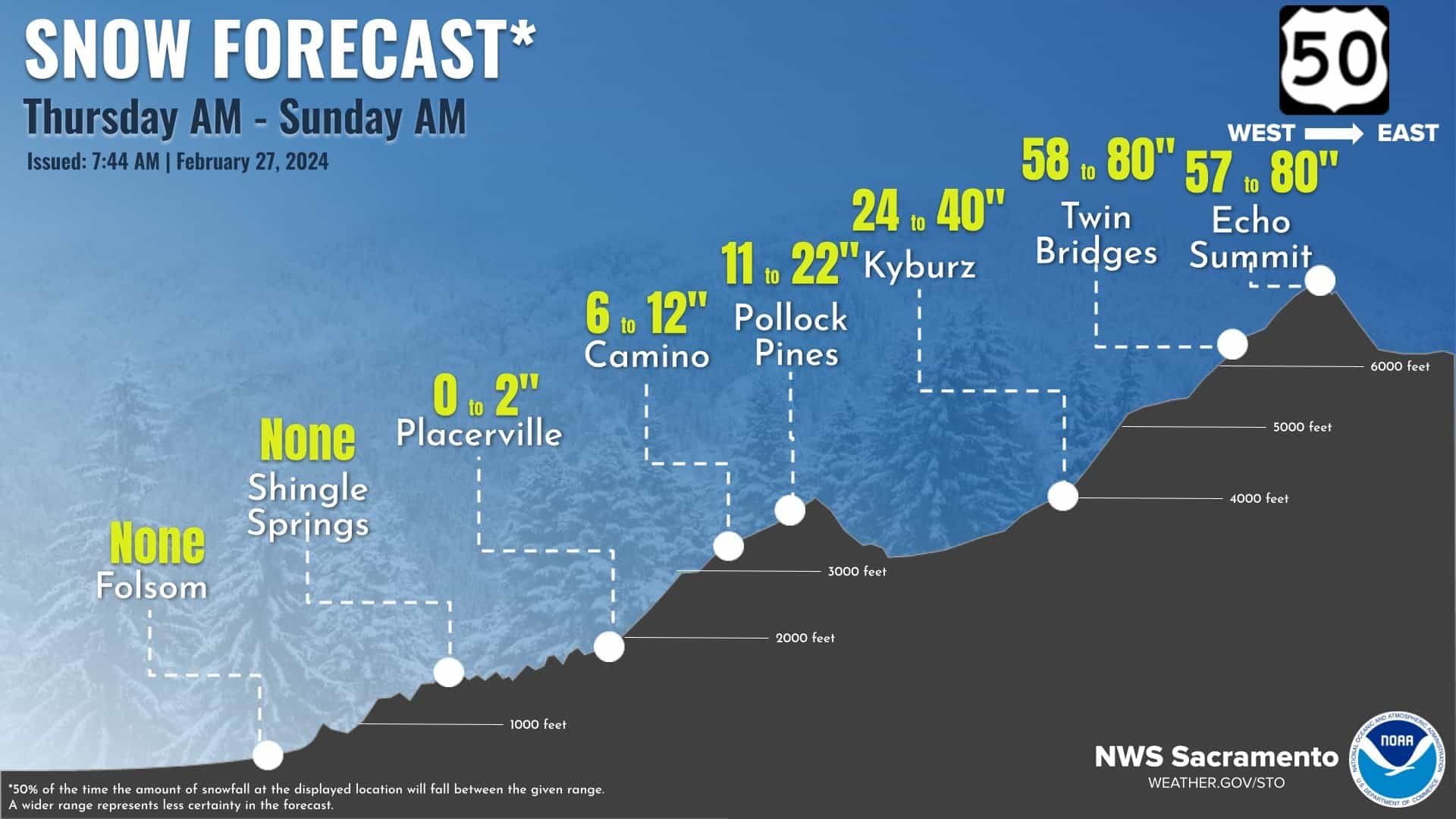
Snow forecast for US-50. Credit: NWS Sacramento

408864241_801098878713113_1283997036408337046_n.jpg
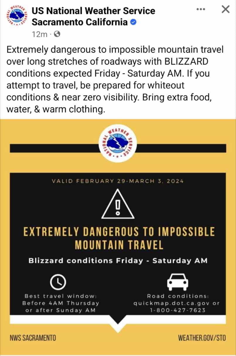
Blizzard warning issued. Credit: NWS Sacramento

Part 1 of 2
 

marsh

On TB every waking moment
Part 2 of 2


426183767_1523044048244104_8126194346297762579_n.jpg
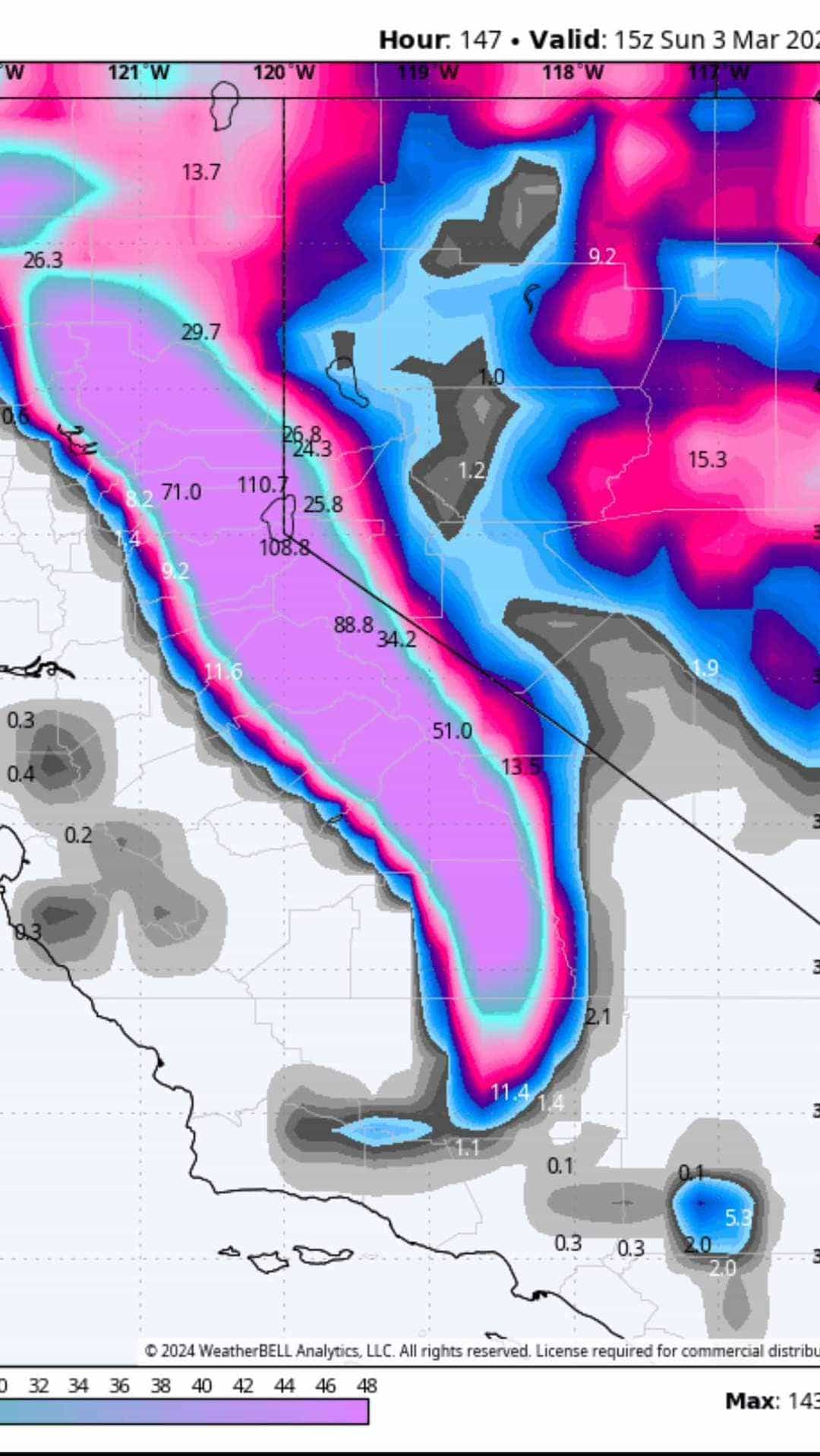
110.7 inches forecast. Credit: Weatherbell

426285476_390502216924865_8371130251482417734_n.jpg
Credit: NWS Sacramento

428421132_2801088293377980_6584038751221769733_n.jpg
Credit: NWS Sacramento

429575966_335737396133013_4392056585234050610_n.jpg
Credit: NWS Sacramento

428241635_333837992991762_508593343413673427_n.jpg
Credit: NWS Sacramento

430228147_310788024949814_6145653217556728337_n.jpg
Credit: NWS Sacramento

 
Last edited by a moderator:

packyderms_wife

Neither here nor there.
Those are linked images, they don't use any appreciable server resources.

true, however they are hard to read on my iPhone. And outside of resizing them I'm not sure how to fix the problem.

BTW we're going back into Red Flag warnings here in Iowa for most of tonight and well into tomorrow night.
 

Publius

TB Fanatic

Up to 12 feet of snow heading to California mountains: What to expect​

Winter storm watches were issued for California, Oregon and Washington.

ByMax Golembo
February 27, 2024, 12:55 PM

Up to 12 feet of snow is heading to California's Sierra Nevada mountains as a new winter storm bears down on the West Coast.

Winter storm watches have been issued for California, Oregon and Washington.

View attachment 462800

The storm will begin in the Pacific Northwest on Wednesday and will reach California by Thursday, bringing rain to the San Francisco area and snow to the mountains.

The rain will spread into Southern California from Friday night into Saturday.

The heaviest snow -- 4 to 12 feet -- will hit the Sierra Nevada mountains Friday to Sunday.

View attachment 462801
Snowfall rates could reach 1 to 3 inches per hour in the mountains. Strong winds are also forecast to cause blowing and drifting snow, which will reduce visibility and make driving in the mountains extremely dangerous.

The winter storm will spread into the Rockies early next week.
Thats a lot of snow in such a short time that works out to 12" inches of rain fall and when all that snow starts to melt look out.
 

zeker

Has No Life - Lives on TB
Red flag warnings for Iowa today and tomorrow! :(
got woke up yesterday morning with heavy thunder and lightning (northern ontario)

then heavy rain.

by noon it had changed to blizzard conditions and 17C below

no accumilation overnite
 
Last edited:

packyderms_wife

Neither here nor there.
Happy March 1st everyone, it's 48F and windy here in Central Iowa this morning. A good chunk of the Front Range and most of Nebraska are under a Red Flag warning. Stay safe everyone.
 

summerthyme

Administrator
_______________
We woke up to a foot of fresh snow... but it's gonna be 65 by Monday. Mud season... ugh! It seems the whole winter has been one extended mud season!

Summerthyme
 

Publius

TB Fanatic
12:00Am reports showing up on YouTube about some serious snow fall in the California area and mountains.
In my life time (1977) I seen a snow storm dump 5'+ foot of snow on the east end of Long Island and it shut us down down no one was moving anywhere, it took all day just to dig a path and remove snow out around the car and could not go anywhere it was just not posable.
Getting 12' foot of snow all at once I cannot imagine dealing with that much snow.
 

packyderms_wife

Neither here nor there.
12:00Am reports showing up on YouTube about some serious snow fall in the California area and mountains.
In my life time (1977) I seen a snow storm dump 5'+ foot of snow on the east end of Long Island and it shut us down down no one was moving anywhere, it took all day just to dig a path and remove snow out around the car and could not go anywhere it was just not posable.
Getting 12' foot of snow all at once I cannot imagine dealing with that much snow.

weren't they predicting that some places would get upwards of 21 feet of snow?
 
Top